
Robin Hood (Newport): Difference between revisions
From International Robin Hood Bibliography
mNo edit summary |
m (Text replacement - "FaceBook" to "Facebook") |
||
| (One intermediate revision by the same user not shown) | |||
| Line 1: | Line 1: | ||
__NOTOC__{{PnItemTop|Lat=50.699911|Lon=-1.286578|AdmDiv=Hampshire|Vicinity=On Robin Hood Street, which connects Barton Road and Furlongs|Type=Public house|Interest=Robin Hood name|Status=Extant|Demonym=English|Riding=|GreaterLondon=|Year=1889|Aka=|Century=|Cluster1=Newport|Cluster2=Isle of Wight|Cluster3=|Image=robin-hood-newport-google-earth-street-view-1.jpg|Postcards=|ExtraCat1=|ExtraCat2=|ExtraCat3=|ExtraCat4=|ExtraCat5=|ExtraLink1=|ExtraLink2=|ExtraLink3=|ExtraLink4=|ExtraLink5=|ExtraLinkName1=|ExtraLinkName2=|ExtraLinkName3=|ExtraLinkName4=|ExtraLinkName5=|GeopointPrefix=|GeopointSuffix=|StatusSuffix=|DatePrefix=|DateSuffix=}} | __NOTOC__{{PnItemTop|Lat=50.699911|Lon=-1.286578|AdmDiv=Hampshire|Vicinity=On Robin Hood Street, which connects Barton Road and Furlongs|Type=Public house|Interest=Robin Hood name|Status=Extant|Demonym=English|Riding=|GreaterLondon=|Year=1889|Aka=|Century=|Cluster1=Newport|Cluster2=Isle of Wight|Cluster3=|Image=robin-hood-newport-google-earth-street-view-1.jpg|Postcards=|ExtraCat1=|ExtraCat2=|ExtraCat3=|ExtraCat4=|ExtraCat5=|ExtraLink1=|ExtraLink2=|ExtraLink3=|ExtraLink4=|ExtraLink5=|ExtraLinkName1=|ExtraLinkName2=|ExtraLinkName3=|ExtraLinkName4=|ExtraLinkName5=|GeopointPrefix=|GeopointSuffix=|StatusSuffix=|DatePrefix=|DateSuffix=}} | ||
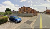
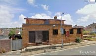
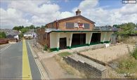
{{#display_map:{{#var:Coords}}~{{#replace:{{PAGENAME}}|'|'}}|width=34%|service=leaflet|enablefullscreen=yes}}<div class="pnMapLegend">The former Robin Hood, Newport</div> | {{#display_map:{{#var:Coords}}~{{#replace:{{PAGENAME}}|'|'}}|width=34%|service=leaflet|enablefullscreen=yes}}<div class="pnMapLegend">The former Robin Hood, Newport</div> | ||
[[File:{{#var:Pnimage}}|thumb|right|500px| | [[File:{{#var:Pnimage}}|thumb|right|500px|The former Robin Hood, Newport / Google Earth Street View.]] | ||
<p id="byline">By Henrik Thiil Nielsen, 2018-10-27. Revised by {{#realname:{{REVISIONUSER}}}}, {{REVISIONYEAR}}-{{REVISIONMONTH}}-{{REVISIONDAY2}}.</p><div class="no-img"> | <p id="byline">By Henrik Thiil Nielsen, 2018-10-27. Revised by {{#realname:{{REVISIONUSER}}}}, {{REVISIONYEAR}}-{{REVISIONMONTH}}-{{REVISIONDAY2}}.</p><div class="no-img"> | ||
The Robin Hood on Robin Hood Street in Newport is recorded in trade directories and census records from 1889 to 1927. It closed in 2014 or later.<ref>[https://pubshistory.com/IsleofWight/Newport/RobinHood.shtml UK Pub History: Robin Hood, Robin Hood Street, Newport, Isle of Wight, Hampshire.]</ref>{{PnItemQry}} | The Robin Hood on Robin Hood Street in Newport is recorded in trade directories and census records from 1889 to 1927. It closed in 2014 or later.<ref>[https://pubshistory.com/IsleofWight/Newport/RobinHood.shtml UK Pub History: Robin Hood, Robin Hood Street, Newport, Isle of Wight, Hampshire.]</ref>{{PnItemQry}} | ||
| Line 23: | Line 23: | ||
<!--== Discussion ==--> | <!--== Discussion ==--> | ||
== Background == | == Background == | ||
* [https://www.facebook.com/Robin-Hood-Pub-839734386075373/ | * [https://www.facebook.com/Robin-Hood-Pub-839734386075373/ Facebook: Robin Hood Pub.] | ||
<!--== Brief mention ==--> | <!--== Brief mention ==--> | ||
Revision as of 11:30, 7 June 2019
The former Robin Hood, Newport
[[File:|thumb|right|500px|The former Robin Hood, Newport / Google Earth Street View.]]
By Henrik Thiil Nielsen, 2018-10-27. Revised by Henrik Thiil Nielsen, 2019-06-07.
The Robin Hood on Robin Hood Street in Newport is recorded in trade directories and census records from 1889 to 1927. It closed in 2014 or later.[1]Template:PnItemQry
Gazetteers
- Not included in Dobson, R. B., ed.; Taylor, J., ed. Rymes of Robyn Hood: an Introduction to the English Outlaw (London, 1976), pp. 293-11.
Sources
Maps
- 25" O.S. map Hampshire and Isle of Wight XCV.2 (c. 1865; surveyed 1862). No Copy in NLS
- 25" O.S. map Hampshire and Isle of Wight XCV.2 (c. 1898; rev. c. 1896). No Copy in NLS
- 25" O.S. map Hampshire and Isle of Wight XCV.2 (1908; rev. 1907) (georeferenced)
- 25" O.S. map Hampshire and Isle of Wight XCV.2 (1908; rev. 1907)
- 6" O.S. map Hampshire & Isle of Wight XCV (1866; surveyed 1863)
- 6" O.S. map Hampshire & Isle of Wight XCV.NW (1898; rev. 1896) (georeferenced)
- 6" O.S. map Hampshire & Isle of Wight XCV.NW (1898; rev. 1896)
- 6" O.S. map Hampshire & Isle of Wight XCV.NW (1909; rev. 1906-1907)
- 6" O.S. map Hampshire & Isle of Wight XCV.NW (c. 1947; rev. 1938).
Background
Notes
The former Robin Hood, Newport / Google Earth Street View.
The former Robin Hood, Newport / Google Earth Street View.
The former Robin Hood, Newport / Google Earth Street View.


