
Robin Hood (Newport): Difference between revisions
From International Robin Hood Bibliography
mNo edit summary |
mNo edit summary |
||
| Line 3: | Line 3: | ||
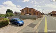
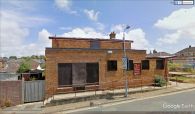
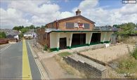
[[File:{{#var:Pnimage}}|thumb|right|500px|Site of the Robin Hood, Newport / Google Earth Street View.]] | [[File:{{#var:Pnimage}}|thumb|right|500px|Site of the Robin Hood, Newport / Google Earth Street View.]] | ||
<p id="byline">By Henrik Thiil Nielsen, 2018-10-27. Revised by {{#realname:{{REVISIONUSER}}}}, {{REVISIONYEAR}}-{{REVISIONMONTH}}-{{REVISIONDAY2}}.</p><div class="no-img"> | <p id="byline">By Henrik Thiil Nielsen, 2018-10-27. Revised by {{#realname:{{REVISIONUSER}}}}, {{REVISIONYEAR}}-{{REVISIONMONTH}}-{{REVISIONDAY2}}.</p><div class="no-img"> | ||
{{PnItemQry}} | The Robin Hood on Robin Hood Street in Newport is recorded in trade directories and census records from 1889 to 1927. It closed in 2014 or later.<ref>[https://pubshistory.com/IsleofWight/Newport/RobinHood.shtml UK Pub History: Robin Hood, Robin Hood Street, Newport, Isle of Wight, Hampshire.]</ref>{{PnItemQry}} | ||
== Gazetteers == | == Gazetteers == | ||
* Not included in {{:Dobson, Richard Barrie 1976a}}, pp. 315-19. | * Not included in {{:Dobson, Richard Barrie 1976a}}, pp. 315-19. | ||
== Sources == | |||
* [https://pubshistory.com/IsleofWight/Newport/RobinHood.shtml UK Pub History: Robin Hood, Robin Hood Street, Newport, Isle of Wight, Hampshire.] | |||
== Maps == | == Maps == | ||
* 25" O.S. map ''Hampshire and Isle of Wight'' XCV.2 (''c.'' 1865; surveyed 1862). No Copy in NLS | * 25" O.S. map ''Hampshire and Isle of Wight'' XCV.2 (''c.'' 1865; surveyed 1862). No Copy in NLS | ||
Revision as of 22:43, 27 October 2018
The former Robin Hood, Newport
[[File:|thumb|right|500px|Site of the Robin Hood, Newport / Google Earth Street View.]]
By Henrik Thiil Nielsen, 2018-10-27. Revised by Henrik Thiil Nielsen, 2018-10-27.
The Robin Hood on Robin Hood Street in Newport is recorded in trade directories and census records from 1889 to 1927. It closed in 2014 or later.[1]Template:PnItemQry
Gazetteers
- Not included in Dobson, R. B., ed.; Taylor, J., ed. Rymes of Robyn Hood: an Introduction to the English Outlaw (London, 1976), pp. 315-19.
Sources
Maps
- 25" O.S. map Hampshire and Isle of Wight XCV.2 (c. 1865; surveyed 1862). No Copy in NLS
- 25" O.S. map Hampshire and Isle of Wight XCV.2 (c. 1898; rev. c. 1896). No Copy in NLS
- 25" O.S. map Hampshire and Isle of Wight XCV.2 (1908; rev. 1907) (georeferenced)
- 25" O.S. map Hampshire and Isle of Wight XCV.2 (1908; rev. 1907)
- 6" O.S. map Hampshire & Isle of Wight XCV (1866; surveyed 1863)
- 6" O.S. map Hampshire & Isle of Wight XCV.NW (1898; rev. 1896) (georeferenced)
- 6" O.S. map Hampshire & Isle of Wight XCV.NW (1898; rev. 1896)
- 6" O.S. map Hampshire & Isle of Wight XCV.NW (1909; rev. 1906-1907)
- 6" O.S. map Hampshire & Isle of Wight XCV.NW (c. 1947; rev. 1938).
Notes
The former Robin Hood, Newport / Google Earth Street View.
The former Robin Hood, Newport / Google Earth Street View.
The former Robin Hood, Newport / Google Earth Street View.


