
Robin Hood (Newport): Difference between revisions
From International Robin Hood Bibliography
(Created page with "__NOTOC__{{PnItemTop|Lat=50.699911|Lon=-1.286578|AdmDiv=Hampshire|Vicinity=On Robin Hood Street, which connects Barton Road and Furlongs|Type=Public house|Interest=Robin Hood...") |
mNo edit summary |
||
| Line 10: | Line 10: | ||
* 25" O.S. map ''Hampshire and Isle of Wight'' XCV.2 (''c.'' 1865; surveyed 1862). No Copy in NLS | * 25" O.S. map ''Hampshire and Isle of Wight'' XCV.2 (''c.'' 1865; surveyed 1862). No Copy in NLS | ||
* 25" O.S. map ''Hampshire and Isle of Wight'' XCV.2 (''c.'' 1898; rev. ''c.'' 1896). No Copy in NLS | * 25" O.S. map ''Hampshire and Isle of Wight'' XCV.2 (''c.'' 1898; rev. ''c.'' 1896). No Copy in NLS | ||
* [https://maps.nls.uk/geo/explore/#zoom=18&lat=50.6996&lon=-1.2871&layers=168&b=5 25" O.S. map ''Hampshire'' and Isle of Wight XCV.2 (1908; rev. 1907)] (georeferenced) | |||
* [https://maps.nls.uk/view/105990616#zoom=5&lat=4630&lon=7272&layers=BT 25" O.S. map ''Hampshire'' and Isle of Wight XCV.2 (1908; rev. 1907)] | * [https://maps.nls.uk/view/105990616#zoom=5&lat=4630&lon=7272&layers=BT 25" O.S. map ''Hampshire'' and Isle of Wight XCV.2 (1908; rev. 1907)] | ||
* [https://maps.nls.uk/view/102343206#zoom=6&lat=8877&lon=5743&layers=BT 6" O.S. map ''Hampshire'' & Isle of Wight XCV (1866; surveyed 1863)] | * [https://maps.nls.uk/view/102343206#zoom=6&lat=8877&lon=5743&layers=BT 6" O.S. map ''Hampshire'' & Isle of Wight XCV (1866; surveyed 1863)] | ||
* [https://maps.nls.uk/geo/explore/#zoom=18&lat=50.6998&lon=-1.2872&layers=6&b=5 6" O.S. map ''Hampshire'' & Isle of Wight XCV.NW (1898; rev. 1896)] (georeferenced) | |||
* [https://maps.nls.uk/view/101442336#zoom=5&lat=4484&lon=5952&layers=BT 6" O.S. map ''Hampshire'' & Isle of Wight XCV.NW (1898; rev. 1896)] | * [https://maps.nls.uk/view/101442336#zoom=5&lat=4484&lon=5952&layers=BT 6" O.S. map ''Hampshire'' & Isle of Wight XCV.NW (1898; rev. 1896)] | ||
* [https://maps.nls.uk/view/101442333#zoom=6&lat=4624&lon=5994&layers=BT 6" O.S. map ''Hampshire'' & Isle of Wight XCV.NW (1909; rev. 1906-1907)] | * [https://maps.nls.uk/view/101442333#zoom=6&lat=4624&lon=5994&layers=BT 6" O.S. map ''Hampshire'' & Isle of Wight XCV.NW (1909; rev. 1906-1907)] | ||
* [https://maps.nls.uk/view/101442330#zoom=6&lat=4530&lon=6080&layers=BT 6" O.S. map ''Hampshire'' & Isle of Wight XCV.NW (''c.'' 1947; rev. 1938) | * [https://maps.nls.uk/view/101442330#zoom=6&lat=4530&lon=6080&layers=BT 6" O.S. map ''Hampshire'' & Isle of Wight XCV.NW (''c.'' 1947; rev. 1938).] | ||
<!--== Discussion == | <!--== Discussion == | ||
== Background == | == Background == | ||
== Brief mention ==--> | == Brief mention ==--> | ||
{{PnItemAlsoSee}} | {{PnItemAlsoSee}} | ||
== Notes == | |||
<references/ | <references/> | ||
</div> | </div> | ||
{{ImgGalleryIntro}} | {{ImgGalleryIntro}} | ||
<gallery widths="195px"> | <gallery widths="195px"> | ||
robin-hood-newport-google-earth-street-view-1.jpg|The former Robin Hood, Newport / Google Earth Street View. | |||
</gallery> | robin-hood-newport-google-earth-street-view-2.jpg|The former Robin Hood, Newport / Google Earth Street View. | ||
robin-hood-newport-google-earth-street-view-3.jpg|The former Robin Hood, Newport / Google Earth Street View. | |||
</gallery> | |||
{{PnItemNav}} | {{PnItemNav}} | ||
Revision as of 22:22, 27 October 2018
The former Robin Hood, Newport
[[File:|thumb|right|500px|Site of the Robin Hood, Newport / Google Earth Street View.]]
By Henrik Thiil Nielsen, 2018-10-27. Revised by Henrik Thiil Nielsen, 2018-10-27.
Gazetteers
- Not included in Dobson, R. B., ed.; Taylor, J., ed. Rymes of Robyn Hood: an Introduction to the English Outlaw (London, 1976), pp. 315-19.
Maps
- 25" O.S. map Hampshire and Isle of Wight XCV.2 (c. 1865; surveyed 1862). No Copy in NLS
- 25" O.S. map Hampshire and Isle of Wight XCV.2 (c. 1898; rev. c. 1896). No Copy in NLS
- 25" O.S. map Hampshire and Isle of Wight XCV.2 (1908; rev. 1907) (georeferenced)
- 25" O.S. map Hampshire and Isle of Wight XCV.2 (1908; rev. 1907)
- 6" O.S. map Hampshire & Isle of Wight XCV (1866; surveyed 1863)
- 6" O.S. map Hampshire & Isle of Wight XCV.NW (1898; rev. 1896) (georeferenced)
- 6" O.S. map Hampshire & Isle of Wight XCV.NW (1898; rev. 1896)
- 6" O.S. map Hampshire & Isle of Wight XCV.NW (1909; rev. 1906-1907)
- 6" O.S. map Hampshire & Isle of Wight XCV.NW (c. 1947; rev. 1938).
Notes
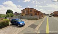
The former Robin Hood, Newport / Google Earth Street View.
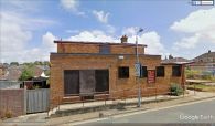
The former Robin Hood, Newport / Google Earth Street View.
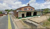
The former Robin Hood, Newport / Google Earth Street View.


