Robin Hood (Hythe Bridge Street, Oxford): Difference between revisions
From International Robin Hood Bibliography
m (Text replacement - "=== Sources ===" to "== Sources ==") |
m (Text replacement - "=== Maps ===" to "== Maps ==") |
||
| Line 14: | Line 14: | ||
* {{:Slater, Isaac 1850a}}. p. 34 of the Oxfordshire section. | * {{:Slater, Isaac 1850a}}. p. 34 of the Oxfordshire section. | ||
== Maps == | |||
Maps of Oxford, focused on Holywell. The Robin Hood is not indicated. | Maps of Oxford, focused on Holywell. The Robin Hood is not indicated. | ||
* [http://maps.nls.uk/view/102346822#zoom=7&lat=939&lon=8185&layers=BT 6" O.S. map ''Oxfordshire'' XXXIII (1887 (surveyed 1876)] | * [http://maps.nls.uk/view/102346822#zoom=7&lat=939&lon=8185&layers=BT 6" O.S. map ''Oxfordshire'' XXXIII (1887 (surveyed 1876)] | ||
Revision as of 14:43, 12 July 2018
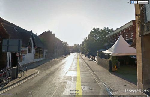
Hyth Bridge Street (formerly Rewley Lane), where the Robin Hood was located.
By Henrik Thiil Nielsen, 2013-06-19. Revised by Henrik Thiil Nielsen, 2018-07-12.
An 1830 trade directory lists this as a tavern or public house in "Ruly lane", i.e. Rewley Lane, the proprietor an Elizabeth Bossom. An 1846 trade directory has the pub at Hythe Bridge Street.[1] The pub had not moved. Sometime between 1830 and 1846 Rewley Lane was renamed Hythe Bridge Street.[2]
From 1846 to 1869 a William Bossom is listed as publican,[3] and in 1881 a George Browning; in 1901 the proprietor was Henry Fosters, Licensed Victualler; in 1903 Frederick Shelton, Beer Retailer.[4]
Sources
- Oxford History: Pigot's 1830 Directory: Oxford: Trades: T
- Oxford History: Oxford inns and hotels in 1846
- Oxford History: Gardner’s 1852 Directory: Oxford: Hotels, Inns, &c.
- Robin Hood, Rewley Road, Oxford, Oxfordshire
- Slater, Isaac, compil. Slater's (Late Pigot & Co.) Royal National and Commercial Directory and Topography of the Counties of Bedfordshire, Buckinghamshire, Cambridgeshire, Huntingdonshire, Norfolk, Oxfordshire, and Suffolk (Manchester and London, 1850). p. 34 of the Oxfordshire section.
Maps
Maps of Oxford, focused on Holywell. The Robin Hood is not indicated.
- 6" O.S. map Oxfordshire XXXIII (1887 (surveyed 1876)
- 6" O.S. map Oxfordshire XXXIII.SE (1900 (rev. 1898)
- 6" O.S. map Oxfordshire XXXIII.SE (1900 (rev. 1898) (georeferenced)
- 6" O.S. map Oxfordshire XXXIII.SE (1922 (rev. 1919)
- 6" O.S. map Oxfordshire XXXIII.SE (c. 1947 (rev. 1938).
Background
- Gelling, Margaret; Stenton, Doris Mary, compil. The Place-Names of Oxfordshire (English Place-Name Society, vols. XXIII, XXIV) (Cambridge, 1953-54), pt. I, p. 42.
- Wood, Anthony; Clark, Andrew, ed. Survey of the Antiquities of the City of Oxford, composed in 1661-6 (Oxford Historical Society, vols. 15, 17, 37) (Oxford, 1889-99), vol. I, p. 332.
Notes
- ↑ See Oxford History: Pigot's 1830 Directory: Oxford: Trades: T; Oxford History: Oxford inns and hotels in 1846.
- ↑ See Wood, Anthony; Clark, Andrew, ed. Survey of the Antiquities of the City of Oxford, composed in 1661-6 (Oxford Historical Society, vols. 15, 17, 37) (Oxford, 1889-99), vol. I, p. 332; Gelling, Margaret; Stenton, Doris Mary, compil. The Place-Names of Oxfordshire (English Place-Name Society, vols. XXIII, XXIV) (Cambridge, 1953-54), pt. I, p. 42.
- ↑ Hunt & Co's Oxford Directory, 1846 (Oxford History: Oxford inns and hotels in 1846); Oxford History: Gardner’s 1852 Directory: Oxford: Hotels, Inns, &c.; Robin Hood, Rewley Road, Oxford, Oxfordshire (1863, 1869); Rewley Road confused with R. Road. Slater, Isaac, compil. Slater's (Late Pigot & Co.) Royal National and Commercial Directory and Topography of the Counties of Bedfordshire, Buckinghamshire, Cambridgeshire, Huntingdonshire, Norfolk, Oxfordshire, and Suffolk (Manchester and London, 1850). p. 34 of the Oxfordshire section.
- ↑ Robin Hood, Rewley Road, Oxford, Oxfordshire.

