
Robin Hood (Hove): Difference between revisions
mNo edit summary |
m (Text replacement - "ImgGalleryIntro" to "ImageGalleryIntroduction") |
||
| (11 intermediate revisions by the same user not shown) | |||
| Line 1: | Line 1: | ||
__NOTOC__{{ | __NOTOC__{{PlaceNamesItemTop|Lat=50.824739|Lon=-0.155476|AdministrativeDivision=Sussex|Vicinity=1-3 Norfolk Place, Hove, Brighton|Type=Public house|Interest=Robin Hood name| | ||
Status=Extant|Demonym=|Riding=|GreaterLondon=|Year=1866|Aka=|Century=|Cluster1=|Cluster2=|Cluster3=|Image=robin-hood-hove-google-earth-street-view-1.jpg|Postcards=<!--Any string means "Yes"-->|ExtraCat1=|ExtraCat2=|ExtraCat3=|ExtraCat4=|ExtraCat5=|ExtraLink1=|ExtraLink2=|ExtraLink3=|ExtraLink4=|ExtraLink5=|ExtraLinkName1=|ExtraLinkName2=|ExtraLinkName3=|ExtraLinkName4=|ExtraLinkName5=|GeopointPrefix=|GeopointSuffix=|VicinitySuffix=|StatusSuffix=|DatePrefix=|DateSuffix=}} | Status=Extant|Demonym=|Riding=|GreaterLondon=|Year=1866|Aka=|Century=|Cluster1=|Cluster2=|Cluster3=|Image=robin-hood-hove-google-earth-street-view-1.jpg|Postcards=<!--Any string means "Yes"-->|ExtraCat1=|ExtraCat2=|ExtraCat3=|ExtraCat4=|ExtraCat5=|ExtraLink1=|ExtraLink2=|ExtraLink3=|ExtraLink4=|ExtraLink5=|ExtraLinkName1=|ExtraLinkName2=|ExtraLinkName3=|ExtraLinkName4=|ExtraLinkName5=|GeopointPrefix=|GeopointSuffix=|VicinitySuffix=|StatusSuffix=|DatePrefix=|DateSuffix=}} | ||
{{#display_map:{{#var:Coords}}~{{#replace:{{PAGENAME}}|'|'}}|width=34%}}<div class="pnMapLegend">{{PAGENAME}}.</div> | {{#display_map:{{#var:Coords}}~{{#replace:{{PAGENAME}}|'|'}}|width=34%|fullscreen=yes}}<div class="pnMapLegend">{{PAGENAME}}.</div> | ||
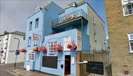
[[File:{{#var: | [[File:{{#var:Image}}|thumb|right|500px|The Robin Hood seen from Norfolk Place / Google Earth Street View.]] | ||
<div class="no-img"><p id="byline">By Henrik Thiil Nielsen, 2020-11-18. Revised by {{#realname:{{REVISIONUSER}}}}, {{REVISIONYEAR}}-{{REVISIONMONTH}}-{{REVISIONDAY2}}.</p> | <div class="no-img"><p id="byline">By Henrik Thiil Nielsen, 2020-11-18. Revised by {{#realname:{{REVISIONUSER}}}}, {{REVISIONYEAR}}-{{REVISIONMONTH}}-{{REVISIONDAY2}}.</p> | ||
The still thriving Robin Hood pub in Hove was in business by 1866. Situated on the old boundary between Brighton and Hove,<ref>[https://m.geograph.org.uk/photo/3833763 Geograph: TQ3004: Robin Hood, Norfolk Place.]</ref> the pub now brands itself as a 'People's pub', distributing its profits to local community organisations.<ref>[https://m.geograph.org.uk/photo/2733231 Geograph: TQ2904: Robin Hood Pub.]</ref> | The still thriving Robin Hood pub in Hove was in business by 1866. Situated on the old boundary between Brighton and Hove,<ref>[https://m.geograph.org.uk/photo/3833763 Geograph: TQ3004: Robin Hood, Norfolk Place.]</ref> the pub now brands itself as a 'People's pub', distributing its profits to local community organisations.<ref>[https://m.geograph.org.uk/photo/2733231 Geograph: TQ2904: Robin Hood Pub.]</ref> | ||
A list of publicans for 1866–1938 can be found at the Pub Wiki.<ref>[https://pubwiki.co.uk/SussexPubs/Brighton/RobinHood.shtml Pub Wiki: Robin Hood, 3 Norfolk Place, Brighton.]</ref> The pub is indicated as 'P.H.' on the early 25" O.S. maps listed below. | |||
<ref>[https://pubwiki.co.uk/SussexPubs/Brighton/RobinHood.shtml Pub Wiki: Robin Hood, 3 Norfolk Place, Brighton.]</ref> | {{PlaceNamesItemAllusionsAndRecords}} | ||
{{ | |||
== Gazetteers == | == Gazetteers == | ||
* Not included in {{:Dobson, Richard Barrie 1976a}}, pp. 293-311. | * Not included in {{:Dobson, Richard Barrie 1976a}}, pp. 293-311. | ||
| Line 18: | Line 17: | ||
== Maps == | == Maps == | ||
* [https://maps.nls.uk/geo/explore/#zoom=18&lat=50.82471&lon=-0.15592&layers=168&b=5 25" O.S. map ''Sussex'' LXVI.9 (1911; rev. 1909)] (georeferenced) | |||
* [https://maps.nls.uk/view/103674088#zoom=7&lat=4230&lon=6153&layers=BT 25" O.S. map ''Sussex'' LXVI.9 (1911; rev. 1909)] | |||
* [https://maps.nls.uk/view/103674085#zoom=7&lat=4075&lon=5976&layers=BT 25" O.S. map ''Sussex'' LXVI.9 (1931; rev. 1929–30)] | |||
* [https://maps.nls.uk/view/102347737#zoom=7&lat=4467&lon=2437&layers=BT 6" O.S. map ''Sussex'' LXVI (1880; surveyed 1873–75)] | |||
* [https://maps.nls.uk/geo/explore/#zoom=17&lat=50.82461&lon=-0.15613&layers=6&b=5 6" O.S. map ''Sussex'' LXVI.SW (1899; rev. 1896–97)] (georeferenced) | |||
* [https://maps.nls.uk/view/101435763#zoom=7&lat=4206&lon=2164&layers=BT 6" O.S. map ''Sussex'' LXVI.SW (1899; rev. 1896–97)] | |||
* [https://maps.nls.uk/view/101435760#zoom=7&lat=4282&lon=2231&layers=BT 6" O.S. map ''Sussex'' LXVI.SW (1912; rev. 1909)] | |||
* [https://maps.nls.uk/view/101435757#zoom=8&lat=4413&lon=2294&layers=BT 6" O.S. map ''Sussex'' LXVI.SW (''c.'' 1933; rev. 1929–30)] | |||
* [https://maps.nls.uk/view/101435754#zoom=8&lat=4331&lon=2242&layers=BT 6" O.S. map ''Sussex'' LXVI.SW (''c.'' 1947; rev. 1938).] | |||
<!--== Discussion == | <!--== Discussion == | ||
* --> | * --> | ||
== Background == | == Background == | ||
* [https://brakspear.co.uk/pub-finder/robin-hood Brakspear: Robin Hood] | |||
* [https://www.facebook.com/robinhoodbn1 Facebook: The Robin Hood] | |||
* [https://www.robinhoodbrighton.com The Robin Hood] (the pub's website) | |||
<!--== Brief mention == | <!--== Brief mention == | ||
* --> | * --> | ||
{{ | {{PlaceNamesItemAlsoSee}} | ||
== Notes == | == Notes == | ||
| Line 32: | Line 42: | ||
</div> | </div> | ||
{{ | {{ImageGalleryIntroduction}} | ||
<gallery widths="195px"> | <gallery widths="195px"> | ||
robin-hood-hove-google-earth-street-view-1.jpg|The Robin Hood seen from Norfolk Place / Google Earth Street View. | robin-hood-hove-google-earth-street-view-1.jpg|The Robin Hood seen from Norfolk Place / Google Earth Street View. | ||
robin-hood-hove-google-earth-street-view-2.jpg|The Robin Hood seen from | robin-hood-hove-google-earth-street-view-2.jpg|The Robin Hood seen from the Norfolk Place – Cross Street intersection / Google Earth Street View. | ||
geograph-3833763-by-Simon-Carey.jpg|The Robin Hood / [https://m.geograph.org.uk/photo/3833763 Simon Carey, 25 Jan. 2014; Creative Commons, via Geograph.] | geograph-3833763-by-Simon-Carey.jpg|The Robin Hood / [https://m.geograph.org.uk/photo/3833763 Simon Carey, 25 Jan. 2014; Creative Commons, via Geograph.] | ||
geograph-2733231-by-Paul-Gillett.jpg|The Robin Hood in its previous, garish pink / [https://m.geograph.org.uk/photo/2733231 Paul Gillett, 17 Dec. 2011; Creative Commons, via Geograph.] | geograph-2733231-by-Paul-Gillett.jpg|The Robin Hood in its previous, garish pink / [https://m.geograph.org.uk/photo/2733231 Paul Gillett, 17 Dec. 2011; Creative Commons, via Geograph.] | ||
| Line 41: | Line 51: | ||
{{ | {{PlaceNamesItemNavigation}} | ||
Revision as of 13:53, 7 January 2021
| Locality | |
|---|---|
| Coordinate | 50.824739, -0.155476 |
| Adm. div. | Sussex |
| Vicinity | 1-3 Norfolk Place, Hove, Brighton |
| Type | Public house |
| Interest | Robin Hood name |
| Status | Extant |
| First Record | 1866 |

By Henrik Thiil Nielsen, 2020-11-18. Revised by Henrik Thiil Nielsen, 2021-01-07.
The still thriving Robin Hood pub in Hove was in business by 1866. Situated on the old boundary between Brighton and Hove,[1] the pub now brands itself as a 'People's pub', distributing its profits to local community organisations.[2]
A list of publicans for 1866–1938 can be found at the Pub Wiki.[3] The pub is indicated as 'P.H.' on the early 25" O.S. maps listed below.
Gazetteers
- Not included in Dobson, R. B., ed.; Taylor, J., ed. Rymes of Robyn Hood: an Introduction to the English Outlaw (London, 1976), pp. 293-311.
Sources
- Geograph: TQ2904: Robin Hood Pub
- Geograph: TQ3004: Robin Hood, Norfolk Place
- Pub Wiki: Robin Hood, 3 Norfolk Place, Brighton.
Maps
- 25" O.S. map Sussex LXVI.9 (1911; rev. 1909) (georeferenced)
- 25" O.S. map Sussex LXVI.9 (1911; rev. 1909)
- 25" O.S. map Sussex LXVI.9 (1931; rev. 1929–30)
- 6" O.S. map Sussex LXVI (1880; surveyed 1873–75)
- 6" O.S. map Sussex LXVI.SW (1899; rev. 1896–97) (georeferenced)
- 6" O.S. map Sussex LXVI.SW (1899; rev. 1896–97)
- 6" O.S. map Sussex LXVI.SW (1912; rev. 1909)
- 6" O.S. map Sussex LXVI.SW (c. 1933; rev. 1929–30)
- 6" O.S. map Sussex LXVI.SW (c. 1947; rev. 1938).
Background
- Brakspear: Robin Hood
- Facebook: The Robin Hood
- The Robin Hood (the pub's website)
Also see
Notes
Image gallery
Click any image to display it in the lightbox, where you can navigate between images by clicking in the right or left side of the current image.
The Robin Hood seen from Norfolk Place / Google Earth Street View.
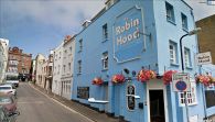
The Robin Hood seen from the Norfolk Place – Cross Street intersection / Google Earth Street View.
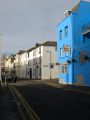
The Robin Hood / Simon Carey, 25 Jan. 2014; Creative Commons, via Geograph.
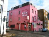
The Robin Hood in its previous, garish pink / Paul Gillett, 17 Dec. 2011; Creative Commons, via Geograph.


