
Robin Hood (Hove): Difference between revisions
m (Text replacement - "PnItemNav" to "PlaceNamesItemNavigation") |
m (Text replacement - "PnItemAlsoSee" to "PlaceNamesItemAlsoSee") |
||
| Line 35: | Line 35: | ||
<!--== Brief mention == | <!--== Brief mention == | ||
* --> | * --> | ||
{{ | {{PlaceNamesItemAlsoSee}} | ||
== Notes == | == Notes == | ||
Revision as of 00:37, 6 January 2021
| Locality | |
|---|---|
| Coordinate | 50.824739, -0.155476 |
| Adm. div. | Sussex |
| Vicinity | 1-3 Norfolk Place, Hove, Brighton |
| Type | Public house |
| Interest | Robin Hood name |
| Status | Extant |
| First Record | 1866 |

By Henrik Thiil Nielsen, 2020-11-18. Revised by Henrik Thiil Nielsen, 2021-01-06.
The still thriving Robin Hood pub in Hove was in business by 1866. Situated on the old boundary between Brighton and Hove,[1] the pub now brands itself as a 'People's pub', distributing its profits to local community organisations.[2]
A list of publicans for 1866–1938 can be found at the Pub Wiki.[3] The pub is indicated as 'P.H.' on the early 25" O.S. maps listed below. Template:PlaceNamesItemQuery
Gazetteers
- Not included in Dobson, R. B., ed.; Taylor, J., ed. Rymes of Robyn Hood: an Introduction to the English Outlaw (London, 1976), pp. 293-311.
Sources
- Geograph: TQ2904: Robin Hood Pub
- Geograph: TQ3004: Robin Hood, Norfolk Place
- Pub Wiki: Robin Hood, 3 Norfolk Place, Brighton.
Maps
- 25" O.S. map Sussex LXVI.9 (1911; rev. 1909) (georeferenced)
- 25" O.S. map Sussex LXVI.9 (1911; rev. 1909)
- 25" O.S. map Sussex LXVI.9 (1931; rev. 1929–30)
- 6" O.S. map Sussex LXVI (1880; surveyed 1873–75)
- 6" O.S. map Sussex LXVI.SW (1899; rev. 1896–97) (georeferenced)
- 6" O.S. map Sussex LXVI.SW (1899; rev. 1896–97)
- 6" O.S. map Sussex LXVI.SW (1912; rev. 1909)
- 6" O.S. map Sussex LXVI.SW (c. 1933; rev. 1929–30)
- 6" O.S. map Sussex LXVI.SW (c. 1947; rev. 1938).
Background
- Brakspear: Robin Hood
- Facebook: The Robin Hood
- The Robin Hood (the pub's website)
Also see
Notes
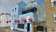
The Robin Hood seen from Norfolk Place / Google Earth Street View.
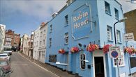
The Robin Hood seen from the Norfolk Place – Cross Street intersection / Google Earth Street View.
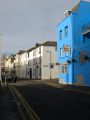
The Robin Hood / Simon Carey, 25 Jan. 2014; Creative Commons, via Geograph.
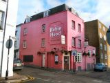
The Robin Hood in its previous, garish pink / Paul Gillett, 17 Dec. 2011; Creative Commons, via Geograph.


