
Robin Hood (Helsby): Difference between revisions
From International Robin Hood Bibliography
m (Text replacement - "|service=leaflet}}" to "|service=leaflet|enablefullscreen=yes}}") |
mNo edit summary |
||
| Line 1: | Line 1: | ||
__NOTOC__{{PnItemTop|Lat=53.2709|Lon=-2.7700|AdmDiv=Cheshire|Vicinity=In Helsby|Type=Public house|Interest=Robin Hood name|Status=Defunct|Demonym=|Riding=|GreaterLondon=|Year=1845|Aka=|Century=|Cluster1=Helsby|Cluster2=|Cluster3=|Image=rh-helsby-garstonian-2009.jpg|Postcards=|ExtraCat1=|ExtraCat2=|ExtraCat3=|ExtraCat4=|ExtraCat5=|ExtraLink1=|ExtraLink2=|ExtraLink3=|ExtraLink4=|ExtraLink5=|ExtraLinkName1=|ExtraLinkName2=|ExtraLinkName3=|ExtraLinkName4=|ExtraLinkName5=|GeopointPrefix=|GeopointSuffix=|StatusSuffix=|DatePrefix=|DateSuffix=}} | __NOTOC__{{PnItemTop|Lat=53.2709|Lon=-2.7700|AdmDiv=Cheshire|Vicinity=In Helsby|Type=Public house|Interest=Robin Hood name|Status=Defunct|Demonym=|Riding=|GreaterLondon=|Year=1845|Aka=|Century=|Cluster1=Helsby|Cluster2=|Cluster3=|Image=rh-helsby-garstonian-2009.jpg|Postcards=|ExtraCat1=|ExtraCat2=|ExtraCat3=|ExtraCat4=|ExtraCat5=|ExtraLink1=|ExtraLink2=|ExtraLink3=|ExtraLink4=|ExtraLink5=|ExtraLinkName1=|ExtraLinkName2=|ExtraLinkName3=|ExtraLinkName4=|ExtraLinkName5=|GeopointPrefix=|GeopointSuffix=|StatusSuffix=|DatePrefix=|DateSuffix=}} | ||
{{#display_map:{{#var:Coords}}~{{#replace:{{PAGENAME}}|'|'}}|width=34%|service=leaflet|enablefullscreen=yes}}<div class="pnMapLegend">The Robin Hood in Helsby.</div> | {{#display_map:{{#var:Coords}}~{{#replace:{{PAGENAME}}|'|'}}|width=34%|service=leaflet|enablefullscreen=yes}}<div class="pnMapLegend">The Robin Hood in Helsby.</div> | ||
[[File:rh-helsby-garstonian-2009.jpg|thumb|right|500px|The Robin Hood in Helsby closed before 4 May 2009, when this photo was taken / [https://www.flickr.com/photos/garstonian/3501778930/in/album-72157616699601259/ Gasrtonian, via Flickr.]]] | |||
<p id="byline">By Henrik Thiil Nielsen, 2017-01-21. Revised by {{#realname:{{REVISIONUSER}}}}, {{REVISIONYEAR}}-{{REVISIONMONTH}}-{{REVISIONDAY2}}.</p> | <p id="byline">By Henrik Thiil Nielsen, 2017-01-21. Revised by {{#realname:{{REVISIONUSER}}}}, {{REVISIONYEAR}}-{{REVISIONMONTH}}-{{REVISIONDAY2}}.</p> | ||
<div class="no-img"> | <div class="no-img"> | ||
The first record I have found of the Robin Hood, until recently located on the corner of Chester Road and [[Lower Robin Hood Lane (Helsby)|Lower Robin Hood Lane]] in Helsby, is a 6" O.S. map of the area published in 1881, based on surveying done 1873-74. It is found on all the later maps listed below (see Maps section). The pub had closed by 4 May 2009, and the building has subsequently been demolished. It was located on the corner of Chester Road and Lower Robin Hood Lane<ref>[https://www.flickr.com/photos/garstonian/3501778930/in/album-72157616699601259/ Flickr: Garstonian: The Robin Hood, Helsby].</ref> | The first record I have found of the Robin Hood, until recently located on the corner of Chester Road and [[Lower Robin Hood Lane (Helsby)|Lower Robin Hood Lane]] in Helsby, is a 6" O.S. map of the area published in 1881, based on surveying done 1873-74. It is found on all the later maps listed below (see Maps section). The pub had closed by 4 May 2009, and the building has subsequently been demolished. It was located on the corner of Chester Road and Lower Robin Hood Lane<ref>[https://www.flickr.com/photos/garstonian/3501778930/in/album-72157616699601259/ Flickr: Garstonian: The Robin Hood, Helsby].</ref> | ||
{{PnItemQry}} | |||
{{ | |||
== Gazetteers == | == Gazetteers == | ||
* Not included in {{:Dobson, Richard Barrie 1976a}}, pp. 293-311 | * Not included in {{:Dobson, Richard Barrie 1976a}}, pp. 293-311 | ||
| Line 28: | Line 26: | ||
</div> | </div> | ||
{{ImgGalleryIntro}} | |||
<gallery widths="195px"> | |||
File:rh-helsby-garstonian-2009.jpg|The Robin Hood in Helsby closed before 4 May 2009, when this photo was taken / [https://www.flickr.com/photos/garstonian/3501778930/in/album-72157616699601259/ Gasrtonian, via Flickr.] | |||
File:rh-helsby-google-maps.jpg|The Robin Hood, boarded up and ready for demolition / Google Earth Street View, Aug. 2009. | |||
</gallery> | |||
{{PnItemNav}} | {{PnItemNav}} | ||
Revision as of 13:25, 30 May 2019
The Robin Hood in Helsby.
File:Rh-helsby-garstonian-2009.jpg
The Robin Hood in Helsby closed before 4 May 2009, when this photo was taken / Gasrtonian, via Flickr.
By Henrik Thiil Nielsen, 2017-01-21. Revised by Henrik Thiil Nielsen, 2019-05-30.
The first record I have found of the Robin Hood, until recently located on the corner of Chester Road and Lower Robin Hood Lane in Helsby, is a 6" O.S. map of the area published in 1881, based on surveying done 1873-74. It is found on all the later maps listed below (see Maps section). The pub had closed by 4 May 2009, and the building has subsequently been demolished. It was located on the corner of Chester Road and Lower Robin Hood Lane[1] Template:PnItemQry
Gazetteers
- Not included in Dobson, R. B., ed.; Taylor, J., ed. Rymes of Robyn Hood: an Introduction to the English Outlaw (London, 1976), pp. 293-311
- Not included in Dodgson, John McN.; Rumble, Alexander R. The Place-Names of Cheshire, pts. I-V (English Place-Name Society, vols. XLIV-XLVIII, LIV, LXXIV) (Cambridge, 1970-72; [s.l.], 1981; Nottingham, 1997).
Maps
- 6" O.S. map Cheshire XXXII (1881; surveyed 1873-74)
- 6" O.S. map Cheshire XXXII.NW (1899; rev. 1897) (georeferenced)
- 6" O.S. map Cheshire XXXII.NW (1911; rev. 1908)
- 6" O.S. map Cheshire XXXII.NW (c. 1936; rev. 1908)
- 6" O.S. map Cheshire XXXII.NW (c. 1944; rev. 1938).
Background
Notes
- Rh-helsby-garstonian-2009.jpg
The Robin Hood in Helsby closed before 4 May 2009, when this photo was taken / Gasrtonian, via Flickr.
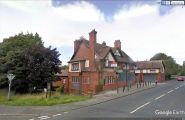
The Robin Hood, boarded up and ready for demolition / Google Earth Street View, Aug. 2009.
