Robin Hood (Giggleswick): Difference between revisions
From International Robin Hood Bibliography
mNo edit summary |
m (Text replacement - "paid subscription required" to "subscription required") |
||
| Line 5: | Line 5: | ||
<div class="no-img"> | <div class="no-img"> | ||
The southern half of the land now forming Settle and Giggleswick Golf Course was formerly known as 'Robin Hood'. It is listed under that name as a pasture with an area of | The southern half of the land now forming Settle and Giggleswick Golf Course was formerly known as 'Robin Hood'. It is listed under that name as a pasture with an area of | ||
4 acres, 2 roods and 25 perches ({{AcreRoodPerchToM2|4|2|25}} m<sup>2</sup>) in a Giggleswick tithe award drawn up 1843-45. Its owner was then the Reverend Edward Francis Witts, its occupier Thomas Maudsley.<ref>{{:Smith, Albert Hugh 1961a}}, vol. VI, p. 156. Plot No. 294 in MS tithe award: [https://www.thegenealogist.com/image_viewer/?imagego=yVaqkz_Qlg-fGyJpQu891TJ9ziRQSuSdqWR3Luzp680ADs0t7bZQ-x6iwshYtLiI7cZhAz_LowJ-SW5QzVjc1swC6UnPeZhX8KeQ57hbaR12kgQgfGqR5Mq3n6UtDDaE&r%5B1%5D=43&r%5B2%5D=168&r%5B3%5D=149 The Genealogist: Piece 43, sub-piece 168, image 149]] (schedule) (Paid subscription required), [https://www.thegenealogist.com/image_viewer/?imagego=5QIH2T2WPVLBR_rz7g5lyEcKvVpX0gSQ9AVPicWgEFeeIZEfYAn_jEkWSn6u0ghP6BQZvptx2fnVZ0OLD5FNpN8ITY7MtewB9FPTC0onZTeR_SOqsfsTFa7Y41syC2id&id=57735556&r%5B1%5D=43&r%5B2%5D=168&r%5B3%5D=002 The Genealogist: Piece 43, sub-piece 168, sub-image 002] (map) ( | 4 acres, 2 roods and 25 perches ({{AcreRoodPerchToM2|4|2|25}} m<sup>2</sup>) in a Giggleswick tithe award drawn up 1843-45. Its owner was then the Reverend Edward Francis Witts, its occupier Thomas Maudsley.<ref>{{:Smith, Albert Hugh 1961a}}, vol. VI, p. 156. Plot No. 294 in MS tithe award: [https://www.thegenealogist.com/image_viewer/?imagego=yVaqkz_Qlg-fGyJpQu891TJ9ziRQSuSdqWR3Luzp680ADs0t7bZQ-x6iwshYtLiI7cZhAz_LowJ-SW5QzVjc1swC6UnPeZhX8KeQ57hbaR12kgQgfGqR5Mq3n6UtDDaE&r%5B1%5D=43&r%5B2%5D=168&r%5B3%5D=149 The Genealogist: Piece 43, sub-piece 168, image 149]] (schedule) (Paid subscription required), [https://www.thegenealogist.com/image_viewer/?imagego=5QIH2T2WPVLBR_rz7g5lyEcKvVpX0gSQ9AVPicWgEFeeIZEfYAn_jEkWSn6u0ghP6BQZvptx2fnVZ0OLD5FNpN8ITY7MtewB9FPTC0onZTeR_SOqsfsTFa7Y41syC2id&id=57735556&r%5B1%5D=43&r%5B2%5D=168&r%5B3%5D=002 The Genealogist: Piece 43, sub-piece 168, sub-image 002] (map) (subscription required). Map drawn 1843, schedule drawn up 1844, official date of receipt 1845.</ref> Unless it is found on O.S. 6" map Yorkshire Sheet 114 (1851, surveyed 1846), which is not available online, I do not believe this field name is included on O.S. maps of the area.<ref>I have not found it on [http://maps.nls.uk/view/102344563 O.S. 6" map Yorkshire CXIV (1896, surveyed 1893)], [http://maps.nls.uk/view/100944353 O.S. 6" map Yorkshire CXIV.SW (1910, rev 1907)] or maps of adjacent areas available online.</ref><!-- | ||
=== Allusions === | === Allusions === | ||
| Line 14: | Line 14: | ||
=== MS sources === | === MS sources === | ||
* [https://www.thegenealogist.com/image_viewer/?imagego=yVaqkz_Qlg-fGyJpQu891TJ9ziRQSuSdqWR3Luzp680ADs0t7bZQ-x6iwshYtLiI7cZhAz_LowJ-SW5QzVjc1swC6UnPeZhX8KeQ57hbaR12kgQgfGqR5Mq3n6UtDDaE&r%5B1%5D=43&r%5B2%5D=168&r%5B3%5D=149 Tithe award, plot No. 294 (The Genealogist: Piece 43, sub-piece 168, image 149)] ( | * [https://www.thegenealogist.com/image_viewer/?imagego=yVaqkz_Qlg-fGyJpQu891TJ9ziRQSuSdqWR3Luzp680ADs0t7bZQ-x6iwshYtLiI7cZhAz_LowJ-SW5QzVjc1swC6UnPeZhX8KeQ57hbaR12kgQgfGqR5Mq3n6UtDDaE&r%5B1%5D=43&r%5B2%5D=168&r%5B3%5D=149 Tithe award, plot No. 294 (The Genealogist: Piece 43, sub-piece 168, image 149)] (subscription required). Schedule drawn up 1844, official date of receipt 1845. | ||
* [https://www.thegenealogist.com/image_viewer/?imagego=5QIH2T2WPVLBR_rz7g5lyEcKvVpX0gSQ9AVPicWgEFeeIZEfYAn_jEkWSn6u0ghP6BQZvptx2fnVZ0OLD5FNpN8ITY7MtewB9FPTC0onZTeR_SOqsfsTFa7Y41syC2id&id=57735556&r%5B1%5D=43&r%5B2%5D=168&r%5B3%5D=002 Tithe map (The Genealogist: Piece 43, sub-piece 168, sub-image 002)] ( | * [https://www.thegenealogist.com/image_viewer/?imagego=5QIH2T2WPVLBR_rz7g5lyEcKvVpX0gSQ9AVPicWgEFeeIZEfYAn_jEkWSn6u0ghP6BQZvptx2fnVZ0OLD5FNpN8ITY7MtewB9FPTC0onZTeR_SOqsfsTFa7Y41syC2id&id=57735556&r%5B1%5D=43&r%5B2%5D=168&r%5B3%5D=002 Tithe map (The Genealogist: Piece 43, sub-piece 168, sub-image 002)] (subscription required). Map, drawn 1843. | ||
=== Printed sources === | === Printed sources === | ||
Revision as of 18:11, 7 February 2018
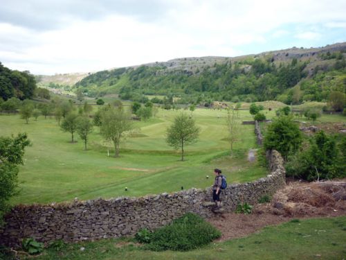
Settle and Giggleswick Golf Course, incorporating the enclosure formerly known a Robin Hood.

This enclosure used to be known as Robin Hood but is now part of Settle and Giggleswick Golf Course / Karl and Ali, 31 May 2010, Creative Commons via Geograph.
By Henrik Thiil Nielsen, 2014-09-04. Revised by Henrik Thiil Nielsen, 2018-02-07.
The southern half of the land now forming Settle and Giggleswick Golf Course was formerly known as 'Robin Hood'. It is listed under that name as a pasture with an area of 4 acres, 2 roods and 25 perches (Template:AcreRoodPerchToM2 m2) in a Giggleswick tithe award drawn up 1843-45. Its owner was then the Reverend Edward Francis Witts, its occupier Thomas Maudsley.[1] Unless it is found on O.S. 6" map Yorkshire Sheet 114 (1851, surveyed 1846), which is not available online, I do not believe this field name is included on O.S. maps of the area.[2]
Gazetteers
- Not included in Dobson, R. B., ed.; Taylor, J., ed. Rymes of Robyn Hood: an Introduction to the English Outlaw (London, 1976), pp. 293-311.
MS sources
- Tithe award, plot No. 294 (The Genealogist: Piece 43, sub-piece 168, image 149) (subscription required). Schedule drawn up 1844, official date of receipt 1845.
- Tithe map (The Genealogist: Piece 43, sub-piece 168, sub-image 002) (subscription required). Map, drawn 1843.
Printed sources
- Smith, A.H. The Place-Names of the West Riding of Yorkshire (English Place-Name Society, vols. XXX-XXXVII) (Cambridge, 1961-63), vol. VI, p. 156.
Background
Notes
- ↑ Smith, A.H. The Place-Names of the West Riding of Yorkshire (English Place-Name Society, vols. XXX-XXXVII) (Cambridge, 1961-63), vol. VI, p. 156. Plot No. 294 in MS tithe award: The Genealogist: Piece 43, sub-piece 168, image 149] (schedule) (Paid subscription required), The Genealogist: Piece 43, sub-piece 168, sub-image 002 (map) (subscription required). Map drawn 1843, schedule drawn up 1844, official date of receipt 1845.
- ↑ I have not found it on O.S. 6" map Yorkshire CXIV (1896, surveyed 1893), O.S. 6" map Yorkshire CXIV.SW (1910, rev 1907) or maps of adjacent areas available online.
