
Robin Hood (Edwinstowe): Difference between revisions
m (Text replacement - "|service=leaflet}}" to "|service=leaflet|enablefullscreen=yes}}") |
m (Text replacement - "Creative Commons via Geograph" to "Creative Commons, via Geograph") |
||
| Line 1: | Line 1: | ||
__NOTOC__{{PnItemTop|Lat=53.183171|Lon=-1.054801|AdmDiv=Nottinghamshire|Vicinity=Clipstone Road, Edwinstowe, Mansfield|Type=Public house|Interest=Robin Hood name|Status=Extant|Demonym=|Riding=|GreaterLondon=|Year=1900|Aka=Robin Hood Inn|Century=|Cluster1=Lidgett|Cluster2=Edwinstowe|Cluster3=Sherwood Forest|Image=geograph-5857494-by-John-Slater.jpg|Postcards=|ExtraCat1=|ExtraCat2=|ExtraCat3=|ExtraCat4=|ExtraCat5=|ExtraLink1=|ExtraLink2=|ExtraLink3=|ExtraLink4=|ExtraLink5=|ExtraLinkName1=|ExtraLinkName2=|ExtraLinkName3=|ExtraLinkName4=|ExtraLinkName5=|GeopointPrefix=|GeopointSuffix=|StatusSuffix=|DatePrefix=|DateSuffix=}} | __NOTOC__{{PnItemTop|Lat=53.183171|Lon=-1.054801|AdmDiv=Nottinghamshire|Vicinity=Clipstone Road, Edwinstowe, Mansfield|Type=Public house|Interest=Robin Hood name|Status=Extant|Demonym=|Riding=|GreaterLondon=|Year=1900|Aka=Robin Hood Inn|Century=|Cluster1=Lidgett|Cluster2=Edwinstowe|Cluster3=Sherwood Forest|Image=geograph-5857494-by-John-Slater.jpg|Postcards=|ExtraCat1=|ExtraCat2=|ExtraCat3=|ExtraCat4=|ExtraCat5=|ExtraLink1=|ExtraLink2=|ExtraLink3=|ExtraLink4=|ExtraLink5=|ExtraLinkName1=|ExtraLinkName2=|ExtraLinkName3=|ExtraLinkName4=|ExtraLinkName5=|GeopointPrefix=|GeopointSuffix=|StatusSuffix=|DatePrefix=|DateSuffix=}} | ||
{{#display_map:{{#var:Coords}}~{{#replace:{{PAGENAME}}|'|'}}|width=34%|service=leaflet|enablefullscreen=yes}}<div class="pnMapLegend">The Robin Hood.</div> | {{#display_map:{{#var:Coords}}~{{#replace:{{PAGENAME}}|'|'}}|width=34%|service=leaflet|enablefullscreen=yes}}<div class="pnMapLegend">The Robin Hood.</div> | ||
[[File:{{#var:Pnimage}}|thumb|right|500px|The Robin Hood at Lidgett / [http://www.geograph.org.uk/photo/5857494 John Slater, 22 Jul. 2018; Creative Commons via Geograph.]]] | [[File:{{#var:Pnimage}}|thumb|right|500px|The Robin Hood at Lidgett / [http://www.geograph.org.uk/photo/5857494 John Slater, 22 Jul. 2018; Creative Commons, via Geograph.]]] | ||
<p id="byline">By Henrik Thiil Nielsen, 2013-08-07. Revised by {{#realname:{{REVISIONUSER}}}}, {{REVISIONYEAR}}-{{REVISIONMONTH}}-{{REVISIONDAY2}}.</p> | <p id="byline">By Henrik Thiil Nielsen, 2013-08-07. Revised by {{#realname:{{REVISIONUSER}}}}, {{REVISIONYEAR}}-{{REVISIONMONTH}}-{{REVISIONDAY2}}.</p> | ||
<div class="no-img"> | <div class="no-img"> | ||
| Line 21: | Line 21: | ||
{{ImgGalleryIntro}} | {{ImgGalleryIntro}} | ||
<gallery widths="195px"> | <gallery widths="195px"> | ||
geograph-5857494-by-John-Slater.jpg|The Robin Hood at Lidgett / [http://www.geograph.org.uk/photo/5857494 John Slater, 22 Jul. 2018; Creative Commons via Geograph.] | geograph-5857494-by-John-Slater.jpg|The Robin Hood at Lidgett / [http://www.geograph.org.uk/photo/5857494 John Slater, 22 Jul. 2018; Creative Commons, via Geograph.] | ||
geograph-2854809-by-Ian-S.jpg|The Robin Hood pub at the Robin Hood Crossroads / [http://www.geograph.org.uk/photo/2854809 Ian S, 18 Mar. 2012; Creative Commons via Geograph.] | geograph-2854809-by-Ian-S.jpg|The Robin Hood pub at the Robin Hood Crossroads / [http://www.geograph.org.uk/photo/2854809 Ian S, 18 Mar. 2012; Creative Commons, via Geograph.] | ||
geograph-087187-by-Mick-Garratt.jpg|Robin Hood Crossroads, known as such after the pub. Taken from the south west on the B6030 to Clipstone / [http://www.geograph.org.uk/photo/87187 Mick Garratt, 4 Dec. 2005; Creative Commons via Geograph.] | geograph-087187-by-Mick-Garratt.jpg|Robin Hood Crossroads, known as such after the pub. Taken from the south west on the B6030 to Clipstone / [http://www.geograph.org.uk/photo/87187 Mick Garratt, 4 Dec. 2005; Creative Commons, via Geograph.] | ||
geograph-2267179-by-Helmut-Zozmann.jpg|Robin Hood Crossroads with the sign of the Robin Hood / [http://www.geograph.org.uk/photo/2267179 Helmut Zozmann, July 1980; Creative Commons via Geograph.] | geograph-2267179-by-Helmut-Zozmann.jpg|Robin Hood Crossroads with the sign of the Robin Hood / [http://www.geograph.org.uk/photo/2267179 Helmut Zozmann, July 1980; Creative Commons, via Geograph.] | ||
robin_hood_edwinstowe_google_earth.jpg|robin_hood_edwinstowe_google_earth.jpg|The Robin Hood / Google Earth Street View. | robin_hood_edwinstowe_google_earth.jpg|robin_hood_edwinstowe_google_earth.jpg|The Robin Hood / Google Earth Street View. | ||
</gallery> | </gallery> | ||
{{PnItemNav}} | {{PnItemNav}} | ||
Revision as of 11:23, 30 May 2019
[[File:|thumb|right|500px|The Robin Hood at Lidgett / John Slater, 22 Jul. 2018; Creative Commons, via Geograph.]]
By Henrik Thiil Nielsen, 2013-08-07. Revised by Henrik Thiil Nielsen, 2019-05-30.
The Robin Hood in Edwinstowe is located adjacent to Robin Hood Farm.
The first record of this place-name I have found is the 6" O.S. map of the area published in 1900, based on a survey carried out in 1897 (see Maps section below). The inn is indicated there as Robin Hood Inn. However, already on the 1884 map, the word "Inn" appears next to Robin Hood Farm. The Robin Hood is still in business. The junction where the pub is situated is known as the Robin Hood Crossroads. There is a Robin Hood Avenue in the immediate vicinity.Template:PnItemQry
Maps
- 6" O.S. map Nottinghamshire XXIII.NE (1884; surveyed 1883-84)
- 6" O.S. map Nottinghamshire XXIII.NE (1900; rev. 1897)
- 6" O.S. map Nottinghamshire XXIII.NE (1920; rev. 1914)
- 6" O.S. map Nottinghamshire XXIII.NE (c. 1948; rev. 1938).
Background
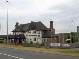
The Robin Hood at Lidgett / John Slater, 22 Jul. 2018; Creative Commons, via Geograph.
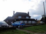
The Robin Hood pub at the Robin Hood Crossroads / Ian S, 18 Mar. 2012; Creative Commons, via Geograph.
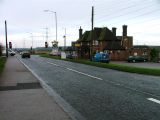
Robin Hood Crossroads, known as such after the pub. Taken from the south west on the B6030 to Clipstone / Mick Garratt, 4 Dec. 2005; Creative Commons, via Geograph.
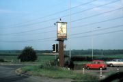
Robin Hood Crossroads with the sign of the Robin Hood / Helmut Zozmann, July 1980; Creative Commons, via Geograph.
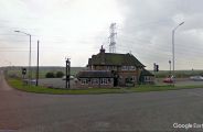
The Robin Hood / Google Earth Street View.


