
Robin Hood (Denholme)
| Locality | |
|---|---|
| Coordinate | 53.801597, -1.891924 |
| Adm. div. | West Riding of Yorkshire |
| Vicinity | In grounds of Foster Park |
| Type | Area |
| Interest | Robin Hood name |
| Status | Defunct |
| First Record | 1849 |


By Henrik Thiil Nielsen, 2020-07-18. Revised by Henrik Thiil Nielsen, 2021-01-07.
Part of the grounds of Foster Park in Denholme was a piece of farmland known as 'Robin Hood' in 1849.
'Robin Hood' is listed in the 1849 tithe award for Thornton in the parish of Bradford with the representatives of Mr Buck as landowners, Joseph Maud as occupier, state of cultivation as 'Arable', and an area of 4 acres, 1 rood and 2 perches (17249.73 m2).[1] The plot immediately north of 'Robin Hood' was called Little John, that below it was Low Robin Hood. Together these three contiguous plots covered and area nearly identical with the present park.
It is anyone's guess what prompted the name 'Robin Hood'. It is perhaps not so much a name of the plot as a reference to part of the vegetation that grew on it. At least three wild flowering plants are or were known under the folk-name 'Robin Hood': Geranium robertianum, Lychnis flos-cuculi and Silene dioica. Since the field for information on nomenclature in the tithe award forms carried the heading 'Name and Description of Lands and Premises' – usually interpreted as Name or Description' etc. by those who filled in the forms – it is entirely possible that what was entered there was in this case not really a name but a descriptive phrase which owners/occupiers came up with in response to the tithe commissioners' or their clerks' request for a name or description for a plot of land for which they did not normally need a name. See further the pages on Robin Hood (Denholme) and Robin Hood (Royston, Barnsley) (2).
Gazetteers
- Not included in Dobson, R. B., ed.; Taylor, J., ed. Rymes of Robyn Hood: an Introduction to the English Outlaw (London, 1976), pp. 293-311.
MS sources
- Tithe award for the township of Thornton in the parish of Bradford (1849) (Piece 043, Sub-Piece 399, Image 307, #1445 – Genealogist.com; subscription required)
- Tithe award map for the township of Thornton in the parish of Bradford (1849) (Piece 43, Sub-Piece 399, Sub-Image 001, #1445 – Genealogist.com; subscription required).
Maps
- 25" O.S. map Yorkshire CCXV.4 (1894; surveyed 1892)
- 25" O.S. map Yorkshire CCXV.4 (1908; rev. 1905) (georeferenced)
- 25" O.S. map Yorkshire CCXV.4 (1908; rev. 1905)
- 25" O.S. map Yorkshire CCXV.4 (1920; rev. 1914)
- 25" O.S. map Yorkshire CCXV.4 (1935; rev. 1934)
- 6" O.S. map Yorkshire 215 (1852; surveyed 1847–49)
- 6" O.S. map Yorkshire CCXV.NE (1894; surveyed 1892–93)
- 6" O.S. map Yorkshire CCXV.NE (1908; rev. 1905) (georeferenced)
- 6" O.S. map Yorkshire CCXV.NE (1908; rev. 1905)
- 6" O.S. map Yorkshire CCXV.NE (1934; rev. 1934)
- 6" O.S. map Yorkshire CCXV.NE (1946; rev. 1938).
Also see
- Denholme place-name cluster
- Robin Hood (Royston, Barnsley) (2)
- Robin Hood - Geranium robertianum
- Robin Hood - Lychnis flos-cuculi
- Robin Hood - Silene dioica.
Notes
- ↑ Tithe award for the township of Thornton in the parish of Bradford (1849) (Piece 043, Sub-Piece 399, Image 307, #1445); Tithe award map for the township of Thornton in the parish of Bradford (1849) (Piece 43, Sub-Piece 399, Sub-Image 001, #1445 – Genealogist.com; subscription required).
Image gallery
Click any image to display it in the lightbox, where you can navigate between images by clicking in the right or left side of the current image.

The lawn in and the spot from which the photo was taken were once part of 'Little John' / Betty Longbottom, 10 June 2008; Creative Commons, via Geograph.
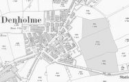
The topmost of the three plots in gray was 'Little John' / Reproduced with the permission of the National Library of Scotland; Creative Commons.
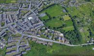
Modern aerial photo of Foster Park and its surroundings / Google Earth Street View.