Robin Hood (Cossall): Difference between revisions
From International Robin Hood Bibliography
m (Text replacement - "ImgGalleryIntro" to "ImageGalleryIntroduction") |
m (Text replacement - "No Copy in NLS" to "No copy in NLS") |
||
| Line 13: | Line 13: | ||
* [http://www.healeyhero.co.uk/rescue/Fatalities/Notts/Notts-C9.html Bob's History of Mining: Cossall Colliery.] | * [http://www.healeyhero.co.uk/rescue/Fatalities/Notts/Notts-C9.html Bob's History of Mining: Cossall Colliery.] | ||
== Maps == | == Maps == | ||
* 25" O.S. map ''Derbyshire'' XLVI.10 (''c.'' 1881; surveyed ''c.'' 1878–1879). No | * 25" O.S. map ''Derbyshire'' XLVI.10 (''c.'' 1881; surveyed ''c.'' 1878–1879). No copy in NLS | ||
* 25" O.S. map ''Nottinghamshire'' XXXVII.10 (''c.'' 1890; surveyed ''c.'' 1879). No | * 25" O.S. map ''Nottinghamshire'' XXXVII.10 (''c.'' 1890; surveyed ''c.'' 1879). No copy in NLS | ||
* [https://maps.nls.uk/geo/explore/#zoom=17&lat=52.98669&lon=-1.29376&layers=168&b=5 25" O.S. map ''Nottinghamshire'' XXXVII.10 (1900; rev. 1899)] (georeferenced) | * [https://maps.nls.uk/geo/explore/#zoom=17&lat=52.98669&lon=-1.29376&layers=168&b=5 25" O.S. map ''Nottinghamshire'' XXXVII.10 (1900; rev. 1899)] (georeferenced) | ||
* [https://maps.nls.uk/view/115391894#zoom=6&lat=5827&lon=6220&layers=BT 25" O.S. map ''Nottinghamshire'' XXXVII.10 (1900; rev. 1899)] | * [https://maps.nls.uk/view/115391894#zoom=6&lat=5827&lon=6220&layers=BT 25" O.S. map ''Nottinghamshire'' XXXVII.10 (1900; rev. 1899)] | ||
Latest revision as of 01:07, 13 February 2021
| Locality | |
|---|---|
| Coordinate | 52.986399, -1.29302 |
| Adm. div. | Nottinghamshire |
| Vicinity | c. 75 m N of Newton's Lane, c. 65 m W of Shilo Way (A6096), Cossall |
| Type | Public house |
| Interest | Robin Hood name |
| Status | Defunct |
| First Record | 1880 |
| A.k.a. | Robin Hoon Inn; Bridge Farm |
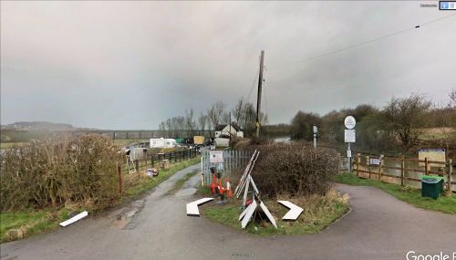
The former Robin Hood, Cassall.
By Henrik Thiil Nielsen, 2020-11-29. Revised by Henrik Thiil Nielsen, 2021-02-13.
A pub named the Robin Hood existed in Cossall, Nottinghamshire, in the 1880s. The building, still standing c. 75 m N of Newton's Lane, is now known as Bridge Farm.
The pub is included on a 6" O.S. map of the area published in 1884, based on a survey carried out 1879–80. It is not included on any of the other early O.S. maps listed below. Inquests into deaths from mining-related accidents were held in the pub in 1880 an 1882, when it was referred to as the 'Robin Hood Inn'.[1]
Gazetteers
- Not included in Dobson, R. B., ed.; Taylor, J., ed. Rymes of Robyn Hood: an Introduction to the English Outlaw (London, 1976), pp. 293-311.
Sources
Maps
- 25" O.S. map Derbyshire XLVI.10 (c. 1881; surveyed c. 1878–1879). No copy in NLS
- 25" O.S. map Nottinghamshire XXXVII.10 (c. 1890; surveyed c. 1879). No copy in NLS
- 25" O.S. map Nottinghamshire XXXVII.10 (1900; rev. 1899) (georeferenced)
- 25" O.S. map Nottinghamshire XXXVII.10 (1900; rev. 1899)
- 25" O.S. map Derbyshire XLVI.10 (1915; rev. 1913)
- 25" O.S. map Derbyshire XLVI.10 (1945; rev. 1937)
- 6" O.S. map Derbyshire XLVI.SW (1884; surveyed 1879–80)
- 25" O.S. map Nottinghamshire XXXVII.10 (1900; rev. 1899)
- 6" O.S. map Derbyshire XLVI.SW (1901; rev. 1899) (georeferenced)
- 25" O.S. map Derbyshire XLVI.10 (1915; rev. 1913)
- 25" O.S. map Derbyshire XLVI.10 (1945; rev. 1937).
Also see
Notes

