
Robin Hood (Appley Bridge): Difference between revisions
mNo edit summary |
m (Text replacement - ", piece" to ", Piece") |
||
| (27 intermediate revisions by 2 users not shown) | |||
| Line 1: | Line 1: | ||
__NOTOC__{{ | __NOTOC__{{PlaceNamesItemTop|Lat=53.597563|Lon=-2.727070|AdministrativeDivision=Lancashire|Vicinity=By Robin Hood Lane N. of Appley Bridge between Hill House Fold Lane and Sparrow Hill/Hall Lane (A5209)|Type=Settlement|Interest=Robin Hood name| | ||
Status=Extant|Demonym=English|Riding=|GreaterLondon=|Year= | Status=Extant|Demonym=English|Riding=|GreaterLondon=|Year=1841|Aka=|Century=|Cluster1=Appley Bridge|Cluster2=|Cluster3=|Image=geograph-3848251-by-Anthony-Parkes.jpg|Postcards=|ExtraCat1=|ExtraCat2=|ExtraCat3=|ExtraCat4=|ExtraCat5=|ExtraLink1=|ExtraLink2=|ExtraLink3=|ExtraLink4=|ExtraLink5=|ExtraLinkName1=|ExtraLinkName2=|ExtraLinkName3=|ExtraLinkName4=|ExtraLinkName5=|GeopointPrefix=|GeopointSuffix=|VicinitySuffix=|StatusSuffix=|DatePrefix=|DateSuffix=}} | ||
{{#display_map:{{#var:Coords}}~{{#replace:{{PAGENAME}}|'|'}}|width=34%}}<div class="pnMapLegend">{{PAGENAME}}.</div> | {{#display_map:{{#var:Coords}}~{{#replace:{{PAGENAME}}|'|'}}|width=34%|enablefullscreen=yes}}<div class="pnMapLegend">{{PAGENAME}}.</div> | ||
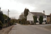
[[File:{{#var: | [[File:{{#var:Image}}|thumb|right|500px|Robin Hood / [https://www.geograph.org.uk/photo/3848251 Anthony Parkes, 15 Feb. 2014, Creative Commons, via Geograph.]]]<div class="no-img"> | ||
<p id="byline">By Henrik Thiil Nielsen, 2018-01-10. Revised by {{#realname:{{REVISIONUSER}}}}, {{REVISIONYEAR}}-{{REVISIONMONTH}}-{{REVISIONDAY2}}.</p | <p id="byline">By Henrik Thiil Nielsen, 2018-01-10. Revised by {{#realname:{{REVISIONUSER}}}}, {{REVISIONYEAR}}-{{REVISIONMONTH}}-{{REVISIONDAY2}}.</p> | ||
'Robin Hood' is the name of a hamlet on Robin Hood Lane, north of Appley Bridge, between Hill House Fold Lane and Sparrow Hill/Hall Lane (A5209). | 'Robin Hood' is the name of a hamlet on Robin Hood Lane, north of Appley Bridge, between Hill House Fold Lane and Sparrow Hill/Hall Lane (A5209). | ||
The earliest reference so far known to IRHB is | The earliest reference so far known to IRHB is the 1841 tithe map for Wrightington.<ref>1841 tithe map for the 'Township of Wrightington in the parish of Eccleston', online at the [https://www.thegenealogist.com Genealogist], Piece 18, sub-piece 350, Sub-Image 001 (£).</ref> The hamlet is also named on a 6" O.S. map published in 1849, based on a survey carried out 1845-46 (see Maps below). The tithe map includes the legend 'Robin Hood' at the corner of High Moor and Robin Hood lanes. The house on that corner, which can be seen in several of the photos included in the image gallery below, was the only one on the northwest side of Robin Hood Lane, and at that time the extension along High Moor Lane had not been added. This rectangular, somewhat wide and quite sturdy, solitary building on a street corner in a hamlet looks as though it may have started life as a public house. IRHB has seen no direct evidence for this, but it would not be surprising to find that the hamlet of Robin Hood acquired its name from a Robin Hood pub at a central location. | ||
{{ | {{PlaceNamesItemAllusionsAndRecords}} | ||
== MS sources == | |||
* 1841 tithe map for the 'Township of Wrightington in the parish of Eccleston', online at the [https://www.thegenealogist.com Genealogist], Piece 18, sub-piece 350, Sub-Image 001 (£). | |||
== Gazetteers == | == Gazetteers == | ||
* {{:Dobson, Richard Barrie 1976a}}, p. 298, ''s.n.'' Robin Hood. | * {{:Dobson, Richard Barrie 1976a}}, p. 298, ''s.n.'' Robin Hood. | ||
== Maps == | |||
* [https://maps.nls.uk/view/126520139#zoom=3&lat=2057&lon=9524&layers=BT 25" O.S. map ''Lancashire'' LXXXV.5 (1894; surveyed 1892)] | |||
* [https://maps.nls.uk/geo/explore/#zoom=17&lat=53.5997&lon=-2.7255&layers=168&b=5 25" O.S. map ''Lancashire'' LXXXV.5 (1908; rev. 1907)] (georeferenced) | |||
* [https://maps.nls.uk/view/126520142#zoom=3&lat=2262&lon=9357&layers=BT 25" O.S. map ''Lancashire'' LXXXV.5 (1908; rev. 1907)] | |||
* [https://maps.nls.uk/view/126520145#zoom=3&lat=2043&lon=9487&layers=BT 25" O.S. map ''Lancashire'' LXXXV.5 (1928; rev. 1927)] | |||
* [https://maps.nls.uk/view/102344018#zoom=5&lat=5623&lon=2745&layers=BT 6" O.S. map ''Lancashire'' LXXXV (1849; surveyed 1845-46)] | |||
* [https://maps.nls.uk/view/101102771#zoom=4&lat=1554&lon=3219&layers=BT 6" O.S. map ''Lancashire'' LXXXV.NW (1894; surveyed 1892-93)] | |||
* [https://maps.nls.uk/geo/explore/#zoom=16&lat=53.5998&lon=-2.7257&layers=6&b=5 6" O.S. map ''Lancashire'' LXXXV.NW (1909; rev. 1907)] (georeferenced)] | |||
* [https://maps.nls.uk/view/101102768#zoom=4&lat=1567&lon=3014&layers=BT 6" O.S. map ''Lancashire'' LXXXV.NW (1909; rev. 1907)] | |||
* [https://maps.nls.uk/view/101102765#zoom=4&lat=1696&lon=2843&layers=BT 6" O.S. map ''Lancashire'' LXXXV.NW (1929; rev. 1927)] | |||
* [https://maps.nls.uk/view/101102762#zoom=4&lat=1795&lon=2982&layers=BT 6" O.S. map ''Lancashire'' LXXXV.NW (1947; rev. 1938).] | |||
== Brief mention == | == Brief mention == | ||
* {{:Taylor, Henry 1899a}}; see p. 17 | |||
* {{:Farrer, William 1906a}}, vol. VI, p. 96. | * {{:Farrer, William 1906a}}, vol. VI, p. 96. | ||
{{ | {{PlaceNamesItemAlsoSee}} | ||
== Notes == | |||
<references/> | |||
</div> | |||
<div id="gallery"> | |||
{{ImageGalleryIntroduction}} | |||
<gallery widths="195px"> | |||
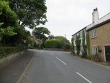
File:geograph-3347312-by-David-Dixon.jpg|Robin Hood: The junction of Robin Hood Lane with High Moor Lane / [https://www.geograph.org.uk/photo/3347312 David Dixon, 22 Feb. 2016, Creative Commons, via Geograph.] | |||
File:geograph-3848251-by-Anthony-Parkes.jpg|Robin Hood / [https://www.geograph.org.uk/photo/3848251 Anthony Parkes, 15 Feb. 2014, Creative Commons, via Geograph.] | |||
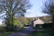
File:geograph-4357772-by-Richard-Webb.jpg|Robin Hood: The end of High Moor Lane / [https://www.geograph.org.uk/photo/4357772 Richard Webb, 2 Jul. 2014, Creative Commons, via Geograph.] | |||
File:geograph-1827758-by-Chris-Denny.jpg|Junction of Moss Lane and Robin Hood Lane seen from Hill House Fold Lane / [https://www.geograph.org.uk/photo/1827758 Chris Denny, 26 Apr. 2010, Creative Commons, via Geograph.] | |||
File:robin-hood-appley-bridge-google-earth-street-view.jpg|Robin Hood / Google Earth Street View. | |||
</gallery> | |||
</div> | </div> | ||
{{PlaceNamesItemNavigation}} | |||
{{ | |||
Latest revision as of 19:13, 22 April 2022
| Locality | |
|---|---|
| Coordinate | 53.597563, -2.72707 |
| Adm. div. | Lancashire |
| Vicinity | By Robin Hood Lane N. of Appley Bridge between Hill House Fold Lane and Sparrow Hill/Hall Lane (A5209) |
| Type | Settlement |
| Interest | Robin Hood name |
| Status | Extant |
| First Record | 1841 |

By Henrik Thiil Nielsen, 2018-01-10. Revised by Henrik Thiil Nielsen, 2022-04-22.
'Robin Hood' is the name of a hamlet on Robin Hood Lane, north of Appley Bridge, between Hill House Fold Lane and Sparrow Hill/Hall Lane (A5209).
The earliest reference so far known to IRHB is the 1841 tithe map for Wrightington.[1] The hamlet is also named on a 6" O.S. map published in 1849, based on a survey carried out 1845-46 (see Maps below). The tithe map includes the legend 'Robin Hood' at the corner of High Moor and Robin Hood lanes. The house on that corner, which can be seen in several of the photos included in the image gallery below, was the only one on the northwest side of Robin Hood Lane, and at that time the extension along High Moor Lane had not been added. This rectangular, somewhat wide and quite sturdy, solitary building on a street corner in a hamlet looks as though it may have started life as a public house. IRHB has seen no direct evidence for this, but it would not be surprising to find that the hamlet of Robin Hood acquired its name from a Robin Hood pub at a central location.
MS sources
- 1841 tithe map for the 'Township of Wrightington in the parish of Eccleston', online at the Genealogist, Piece 18, sub-piece 350, Sub-Image 001 (£).
Gazetteers
- Dobson, R. B., ed.; Taylor, J., ed. Rymes of Robyn Hood: an Introduction to the English Outlaw (London, 1976), p. 298, s.n. Robin Hood.
Maps
- 25" O.S. map Lancashire LXXXV.5 (1894; surveyed 1892)
- 25" O.S. map Lancashire LXXXV.5 (1908; rev. 1907) (georeferenced)
- 25" O.S. map Lancashire LXXXV.5 (1908; rev. 1907)
- 25" O.S. map Lancashire LXXXV.5 (1928; rev. 1927)
- 6" O.S. map Lancashire LXXXV (1849; surveyed 1845-46)
- 6" O.S. map Lancashire LXXXV.NW (1894; surveyed 1892-93)
- 6" O.S. map Lancashire LXXXV.NW (1909; rev. 1907) (georeferenced)]
- 6" O.S. map Lancashire LXXXV.NW (1909; rev. 1907)
- 6" O.S. map Lancashire LXXXV.NW (1929; rev. 1927)
- 6" O.S. map Lancashire LXXXV.NW (1947; rev. 1938).
Brief mention
- Taylor, Henry. 'The Ancient Crosses of Lancashire: The Hundred of Leyland', Transactions of the Lancashire and Cheshire Antiquarian Society, vol. XVII (1899), pp. 1-31; see p. 17
- Farrer, William, ed.; Brownbill, J., ed. The Victoria History of the County of Lancaster (London, 1906), vol. VI, p. 96.
Also see
Notes
- ↑ 1841 tithe map for the 'Township of Wrightington in the parish of Eccleston', online at the Genealogist, Piece 18, sub-piece 350, Sub-Image 001 (£).
Image gallery
Click any image to display it in the lightbox, where you can navigate between images by clicking in the right or left side of the current image.
Robin Hood: The junction of Robin Hood Lane with High Moor Lane / David Dixon, 22 Feb. 2016, Creative Commons, via Geograph.
Robin Hood: The end of High Moor Lane / Richard Webb, 2 Jul. 2014, Creative Commons, via Geograph.
Junction of Moss Lane and Robin Hood Lane seen from Hill House Fold Lane / Chris Denny, 26 Apr. 2010, Creative Commons, via Geograph.
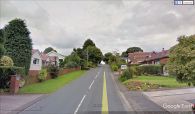
Robin Hood / Google Earth Street View.


