Robin Hood (Ancoats, Manchester)
From International Robin Hood Bibliography
| Locality | |
|---|---|
| Coordinate | 53.484394, -2.22932 |
| Adm. div. | Lancashire |
| Vicinity | Blossom Street, Ancoats, Manchester |
| Type | Public house |
| Interest | Robin Hood name |
| Status | Defunct |
| First Record | 1851? |
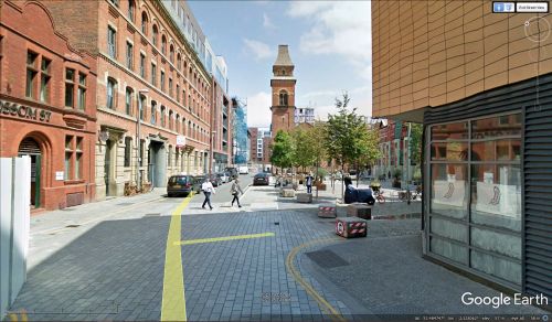
Blossom Street where the Robin Hood was situated.
By Henrik Thiil Nielsen, 2019-03-06. Revised by Henrik Thiil Nielsen, 2022-04-22.
For a few years during the 1850s there was a Robin Hood pub somewhere on Blossom Street, Ancoats, Manchester. It disappeared when warehouses were built in the area.[1]
This short-lived pub is not included on any of the O.S. maps listed below. A Thomas Edwards, "Beer Retailer", is listed at 40 Blossom Street in the 1851 census, and in that of 1861 an Alice Edwards, "Beerhousekeeper" at 42 Blossom Street,[2] but no pub name is cited.
Gazetteers
- Not included in Dobson, R. B., ed.; Taylor, J., ed. Rymes of Robyn Hood: an Introduction to the English Outlaw (London, 1976), pp. 293-311.
Maps
- 25" O.S. map Lancashire CIV.7 (1893; surveyed 1888-91)
- 25" O.S. map Lancashire CIV.7 (c. 1908; rev. c. 1904). No copy in NLS
- 25" O.S. map Lancashire CIV.7 (1922; rev. 1915) (georeferenced)
- 25" O.S. map Lancashire CIV.7 (1922; rev. 1915)
- 25" O.S. map Lancashire CIV.7 (1934; rev. 1931-32)
- 6" O.S. map Lancashire CIV (1848; surveyed 1845)
- 6" O.S. map Lancashire CIV.NE (1891; surveyed 1888-91)
- 6" O.S. map Lancashire CIV.NE (1909; rev. 1905-1906) (georeferenced)
- 6" O.S. map Lancashire CIV.NE (1909; rev. 1905-1906)
- 6" O.S. map Lancashire CIV (1923; rev. 1915-21)
- 6" O.S. map Lancashire CIV.NE (1923; rev. 1915-21)
- 6" O.S. map Lancashire CIV.NE (1936; rev. 1931-32)
- 6" O.S. map Lancashire CIV.NE (c. 1947; rev. 1938).
Discussion
Background
- The Genealogist: 1851 Census: Lancashire, Piece 225_2, Sub-Image 00181 (£)
- The Genealogist: 1861 Census: Lancashire, Piece 02928, Sub-Image 00184 (£).
Also see
Notes

