
Robin Hood (Amblecote): Difference between revisions
From International Robin Hood Bibliography
m (Text replacement - "PlaceNamesItemQuery" to "PlaceNamesItemAllusionsAndRecords") |
m (Text replacement - "ImgGalleryIntro" to "ImageGalleryIntroduction") |
||
| Line 40: | Line 40: | ||
</div> | </div> | ||
{{ | {{ImageGalleryIntroduction}} | ||
<gallery widths="195px"> | <gallery widths="195px"> | ||
geograph-3007383-by-P-L-Chadwick.jpg|The Robin Hood / [https://m.geograph.org.uk/photo/3007383 P. L. Chadwick, 23 June 2012, Creative Commons, via Geograph.] | geograph-3007383-by-P-L-Chadwick.jpg|The Robin Hood / [https://m.geograph.org.uk/photo/3007383 P. L. Chadwick, 23 June 2012, Creative Commons, via Geograph.] | ||
Latest revision as of 13:53, 7 January 2021
| Locality | |
|---|---|
| Coordinate | 52.470936, -2.146617 |
| Adm. div. | Staffordshire |
| Vicinity | 196-200 Collis Street, Stourbridge |
| Type | Public house |
| Interest | Robin Hood name |
| Status | Extant |
| First Record | 1940 |
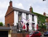
The Robin Hood in Amblecote.

The Robin Hood / P. L. Chadwick, 23 June 2012, Creative Commons, via Geograph.
By Henrik Thiil Nielsen, 2020-11-04. Revised by Henrik Thiil Nielsen, 2021-01-07.
The still thriving Robin Hood pub in Amblecote was in existence by 1940.
Pub Wiki lists information on the publican etc. for 1940 only.[1] Formerly 15 Collis Street, the address is now 196-200 Collis Street. The pub is not indicated on the maps listed below.
Gazetteers
- Not included in Dobson, R. B., ed.; Taylor, J., ed. Rymes of Robyn Hood: an Introduction to the English Outlaw (London, 1976), pp. 293-311.
Sources
Maps
- 25" O.S. map Staffordshire LXXI.6 (1903; rev. 1901) (georeferenced)
- 25" O.S. map Staffordshire LXXI.6 (1884; surveyed 1882)
- 25" O.S. map Staffordshire LXXI.6 (1903; rev. 1901)
- 25" O.S. map Staffordshire LXXI.6 (1919; rev. 1914)
- 25" O.S. map Staffordshire LXXI.6 (1947; rev. 1938)
- 6" O.S. map Staffordshire LXXI.NW (1903; rev. 1901) (georeferenced)
- 6" O.S. map Staffordshire LXXI.NW (1886; surveyed 1882)
- 6" O.S. map Staffordshire LXXI.NW (1903; rev. 1901)
- 6" O.S. map Staffordshire LXXI (1921; rev. 1914)
- 6" O.S. map Staffordshire LXXI.NW (1921; rev. 1914)
- 6" O.S. map Staffordshire LXXI.NW (c. 1949; rev. 1948).
Background
Also see
Notes
Image gallery
Click any image to display it in the lightbox, where you can navigate between images by clicking in the right or left side of the current image.
The Robin Hood / P. L. Chadwick, 23 June 2012, Creative Commons, via Geograph.
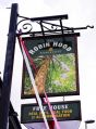
Sign of the Robin Hood / P. L. Chadwick, 23 June 2012, Creative Commons, via Geograph.
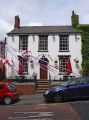
The Robin Hood / P. L. Chadwick, 23 June 2012, Creative Commons, via Geograph.

