
Robin Hood (Amblecote): Difference between revisions
From International Robin Hood Bibliography
m (Text replacement - "PnItemQry" to "PlaceNamesItemQuery") |
m (Text replacement - "PnItemNav" to "PlaceNamesItemNavigation") |
||
| Line 48: | Line 48: | ||
{{ | {{PlaceNamesItemNavigation}} | ||
Revision as of 00:22, 6 January 2021
| Locality | |
|---|---|
| Coordinate | 52.470936, -2.146617 |
| Adm. div. | Staffordshire |
| Vicinity | 196-200 Collis Street, Stourbridge |
| Type | Public house |
| Interest | Robin Hood name |
| Status | Extant |
| First Record | 1940 |
The Robin Hood in Amblecote.

The Robin Hood / P. L. Chadwick, 23 June 2012, Creative Commons, via Geograph.
By Henrik Thiil Nielsen, 2020-11-04. Revised by Henrik Thiil Nielsen, 2021-01-06.
The still thriving Robin Hood pub in Amblecote was in existence by 1940.
Pub Wiki lists information on the publican etc. for 1940 only.[1] Formerly 15 Collis Street, the address is now 196-200 Collis Street. The pub is not indicated on the maps listed below. Template:PlaceNamesItemQuery
Gazetteers
- Not included in Dobson, R. B., ed.; Taylor, J., ed. Rymes of Robyn Hood: an Introduction to the English Outlaw (London, 1976), pp. 293-311.
Sources
Maps
- 25" O.S. map Staffordshire LXXI.6 (1903; rev. 1901) (georeferenced)
- 25" O.S. map Staffordshire LXXI.6 (1884; surveyed 1882)
- 25" O.S. map Staffordshire LXXI.6 (1903; rev. 1901)
- 25" O.S. map Staffordshire LXXI.6 (1919; rev. 1914)
- 25" O.S. map Staffordshire LXXI.6 (1947; rev. 1938)
- 6" O.S. map Staffordshire LXXI.NW (1903; rev. 1901) (georeferenced)
- 6" O.S. map Staffordshire LXXI.NW (1886; surveyed 1882)
- 6" O.S. map Staffordshire LXXI.NW (1903; rev. 1901)
- 6" O.S. map Staffordshire LXXI (1921; rev. 1914)
- 6" O.S. map Staffordshire LXXI.NW (1921; rev. 1914)
- 6" O.S. map Staffordshire LXXI.NW (c. 1949; rev. 1948).
Background
Notes

The Robin Hood / P. L. Chadwick, 23 June 2012, Creative Commons, via Geograph.
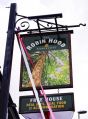
Sign of the Robin Hood / P. L. Chadwick, 23 June 2012, Creative Commons, via Geograph.

The Robin Hood / P. L. Chadwick, 23 June 2012, Creative Commons, via Geograph.

