
Robin Hood (Amblecote): Difference between revisions
From International Robin Hood Bibliography
mNo edit summary |
mNo edit summary |
||
| Line 29: | Line 29: | ||
* --> | * --> | ||
== Background == | == Background == | ||
* [https://www.facebook.com/TheRobinHoodInn Facebook: The | * [https://www.facebook.com/TheRobinHoodInn Facebook: The Robin Hood Inn.] | ||
<!--== Brief mention == | <!--== Brief mention == | ||
* --> | * --> | ||
Revision as of 17:39, 4 November 2020
The Robin Hood in Amblecote.
[[File:|thumb|right|500px|The Robin Hood / P. L. Chadwick, 23 June 2012, Creative Commons, via Geograph.]]
By Henrik Thiil Nielsen, 2020-11-04. Revised by Henrik Thiil Nielsen, 2020-11-04.
The still thriving Robin Hood pub in Amblecote was in existence by 1940.
Pub Wiki lists information on the publican etc. for 1940 only.[1] Formerly 15 Collis Street, the address is now 196-200 Collis Street. Template:PnItemQry
Gazetteers
- Not included in Dobson, R. B., ed.; Taylor, J., ed. Rymes of Robyn Hood: an Introduction to the English Outlaw (London, 1976), pp. 293-311.
Sources
Maps
- 25" O.S. map Staffordshire LXXI.6 (1903; rev. 1901) (georeferenced)
- 25" O.S. map Staffordshire LXXI.6 (1884; surveyed 1882)
- 25" O.S. map Staffordshire LXXI.6 (1903; rev. 1901)
- 25" O.S. map Staffordshire LXXI.6 (1919; rev. 1914)
- 25" O.S. map Staffordshire LXXI.6 (1947; rev. 1938)
- 6" O.S. map Staffordshire LXXI.NW (1903; rev. 1901) (georeferenced)
- 6" O.S. map Staffordshire LXXI.NW (1886; surveyed 1882)
- 6" O.S. map Staffordshire LXXI.NW (1903; rev. 1901)
- 6" O.S. map Staffordshire LXXI (1921; rev. 1914)
- 6" O.S. map Staffordshire LXXI.NW (1921; rev. 1914)
- 6" O.S. map Staffordshire LXXI.NW (c. 1949; rev. 1948).
Background
Notes
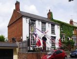
The Robin Hood / P. L. Chadwick, 23 June 2012, Creative Commons, via Geograph.
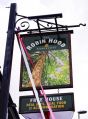
Sign of the Robin Hood / P. L. Chadwick, 23 June 2012, Creative Commons, via Geograph.
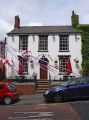
The Robin Hood / P. L. Chadwick, 23 June 2012, Creative Commons, via Geograph.


