
Robin Hood (Amblecote): Difference between revisions
From International Robin Hood Bibliography
(Created page with "__NOTOC__{{PnItemTop|Lat=52.470936|Lon=-2.146617|AdmDiv=Staffordshire|Vicinity=196-200 Collis Street, Stourbridge|Type=Public house|Interest=Robin Hood name| Status=Extant|Dem...") |
mNo edit summary |
||
| Line 3: | Line 3: | ||
{{#display_map:{{#var:Coords}}~{{#replace:{{PAGENAME}}|'|'}}|width=34%}}<div class="pnMapLegend">The Robin Hood in Amblecote.</div> | {{#display_map:{{#var:Coords}}~{{#replace:{{PAGENAME}}|'|'}}|width=34%}}<div class="pnMapLegend">The Robin Hood in Amblecote.</div> | ||
[[File:{{#var:Pnimage}}|thumb|right|500px|The Robin Hood / [https://m.geograph.org.uk/photo/3007383 P. L. Chadwick, 23 June 2012, Creative Commons, via Geograph.]]] | [[File:{{#var:Pnimage}}|thumb|right|500px|The Robin Hood / [https://m.geograph.org.uk/photo/3007383 P. L. Chadwick, 23 June 2012, Creative Commons, via Geograph.]]] | ||
<div class="no-img"><p id="byline">By | <div class="no-img"><p id="byline">By Henrik Thiil Nielsen, 2020-11-04. Revised by {{#realname:{{REVISIONUSER}}}}, {{REVISIONYEAR}}-{{REVISIONMONTH}}-{{REVISIONDAY2}}.</p> | ||
The still thriving Robin Hood pub in Amblecote was in existence by 1940. | The still thriving Robin Hood pub in Amblecote was in existence by 1940. | ||
| Line 10: | Line 10: | ||
== Gazetteers == | == Gazetteers == | ||
* Not included in {{:Dobson, Richard Barrie 1976a}}, pp. 293-311. | * Not included in {{:Dobson, Richard Barrie 1976a}}, pp. 293-311. | ||
== Sources == | == Sources == | ||
* [https://pubwiki.co.uk/Staffordshire/Amblecote/RobinHood.shtml Pub Wiki: Robin Hood, 15 Collis street, Amblecote, Staffordshire.] | * [https://pubwiki.co.uk/Staffordshire/Amblecote/RobinHood.shtml Pub Wiki: Robin Hood, 15 Collis street, Amblecote, Staffordshire.] | ||
== Maps == | == Maps == | ||
* [https://maps.nls.uk/geo/explore/#zoom=17&lat=52.47157&lon=-2.14714&layers=168&b=5 25" O.S. map ''Staffordshire'' LXXI.6 (1903; rev. 1901)] (georeferenced) | |||
* [https://maps.nls.uk/view/115476331#zoom=6&lat=1525&lon=5391&layers=BT 25" O.S. map ''Staffordshire'' LXXI.6 (1884; surveyed 1882)] | |||
* [https://maps.nls.uk/view/115476334#zoom=6&lat=1671&lon=5250&layers=BT 25" O.S. map ''Staffordshire'' LXXI.6 (1903; rev. 1901)] | |||
* [https://maps.nls.uk/view/115476337#zoom=7&lat=2092&lon=5554&layers=BT 25" O.S. map ''Staffordshire'' LXXI.6 (1919; rev. 1914)] | |||
* [https://maps.nls.uk/view/115476340#zoom=7&lat=2061&lon=5670&layers=BT 25" O.S. map ''Staffordshire'' LXXI.6 (1947; rev. 1938)] | |||
* [https://maps.nls.uk/geo/explore/#zoom=16&lat=52.47032&lon=-2.15025&layers=6&b=5 6" O.S. map ''Staffordshire'' LXXI.NW (1903; rev. 1901)] (georeferenced) | |||
* [https://maps.nls.uk/view/101597660#zoom=6&lat=1321&lon=5745&layers=BT 6" O.S. map ''Staffordshire'' LXXI.NW (1886; surveyed 1882)] | |||
* [https://maps.nls.uk/view/101597657#zoom=7&lat=1520&lon=5504&layers=BT 6" O.S. map ''Staffordshire'' LXXI.NW (1903; rev. 1901)] | |||
* [https://maps.nls.uk/view/102352880#zoom=6&lat=5459&lon=6412&layers=BT 6" O.S. map ''Staffordshire'' LXXI (1921; rev. 1914)] | |||
* [https://maps.nls.uk/view/101597654#zoom=6&lat=1713&lon=5643&layers=BT 6" O.S. map ''Staffordshire'' LXXI.NW (1921; rev. 1914)] | |||
* [https://maps.nls.uk/view/101597651#zoom=7&lat=1687&lon=5669&layers=BT 6" O.S. map ''Staffordshire'' LXXI.NW (''c.'' 1949; rev. 1948).] | |||
<!--== Discussion == | <!--== Discussion == | ||
* --> | * --> | ||
Revision as of 17:33, 4 November 2020
The Robin Hood in Amblecote.
[[File:|thumb|right|500px|The Robin Hood / P. L. Chadwick, 23 June 2012, Creative Commons, via Geograph.]]
By Henrik Thiil Nielsen, 2020-11-04. Revised by Henrik Thiil Nielsen, 2020-11-04.
The still thriving Robin Hood pub in Amblecote was in existence by 1940.
Pub Wiki lists information on the publican etc. for 1940 only. Formerly 15 Collis Street, the address is now 196-200 Collis Street. Template:PnItemQry
Gazetteers
- Not included in Dobson, R. B., ed.; Taylor, J., ed. Rymes of Robyn Hood: an Introduction to the English Outlaw (London, 1976), pp. 293-311.
Sources
Maps
- 25" O.S. map Staffordshire LXXI.6 (1903; rev. 1901) (georeferenced)
- 25" O.S. map Staffordshire LXXI.6 (1884; surveyed 1882)
- 25" O.S. map Staffordshire LXXI.6 (1903; rev. 1901)
- 25" O.S. map Staffordshire LXXI.6 (1919; rev. 1914)
- 25" O.S. map Staffordshire LXXI.6 (1947; rev. 1938)
- 6" O.S. map Staffordshire LXXI.NW (1903; rev. 1901) (georeferenced)
- 6" O.S. map Staffordshire LXXI.NW (1886; surveyed 1882)
- 6" O.S. map Staffordshire LXXI.NW (1903; rev. 1901)
- 6" O.S. map Staffordshire LXXI (1921; rev. 1914)
- 6" O.S. map Staffordshire LXXI.NW (1921; rev. 1914)
- 6" O.S. map Staffordshire LXXI.NW (c. 1949; rev. 1948).
Notes
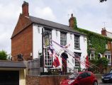
The Robin Hood / P. L. Chadwick, 23 June 2012, Creative Commons, via Geograph.
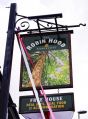
Sign of the Robin Hood / P. L. Chadwick, 23 June 2012, Creative Commons, via Geograph.
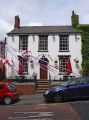
The Robin Hood / P. L. Chadwick, 23 June 2012, Creative Commons, via Geograph.


