
Robin Hood (Altofts): Difference between revisions
mNo edit summary |
mNo edit summary |
||
| Line 4: | Line 4: | ||
<p id="byline">By Henrik Thiil Nielsen, 2013-08-07. Revised by {{#realname:{{REVISIONUSER}}}}, {{REVISIONYEAR}}-{{REVISIONMONTH}}-{{REVISIONDAY2}}.</p> | <p id="byline">By Henrik Thiil Nielsen, 2013-08-07. Revised by {{#realname:{{REVISIONUSER}}}}, {{REVISIONYEAR}}-{{REVISIONMONTH}}-{{REVISIONDAY2}}.</p> | ||
<div class="no-img"> | <div class="no-img"> | ||
The Robin Hood on Church Road in Altofts, not far from Wakefield, has been a locally owned community pub since 2015,<ref>[http://robinhoodaltofts.co.uk.websitebuilder.prositehosting.co.uk/ http://robinhoodaltofts.co.uk.websitebuilder.prositehosting.co.uk/home The Robin Hood – Altofts] (pub's website)</ref> but it is not clear when it was established. It is not included in any of the O.S. maps listed below. | |||
== Gazetteers == | |||
* Not included in {{:Dobson, Richard Barrie 1976a|Dobson & Taylor}}, pp. 293-311. | |||
== Maps == | |||
* [https://maps.nls.uk/view/125644705#zoom=4&lat=8391&lon=1218&layers=BT 25" O.S. map ''Yorkshire'' CCXXXIV.13 (1892; surveyed 1890)] | |||
* [https://maps.nls.uk/geo/explore/#zoom=17&lat=53.7073&lon=-1.4395&layers=168&b=5 25" O.S. map ''Yorkshire'' CCXXXIV.13 (1908; rev. 1905)] (georeferenced) | |||
* [https://maps.nls.uk/view/125644708#zoom=4&lat=9011&lon=1403&layers=BT 25" O.S. map ''Yorkshire'' CCXXXIV.13 (1908; rev. 1905)] | |||
* [https://maps.nls.uk/view/125644711#zoom=5&lat=8611&lon=1208&layers=BT 25" O.S. map ''Yorkshire'' CCXXXIV.13 (1933; rev. 1932)] | |||
* [https://maps.nls.uk/view/102345007#zoom=6&lat=2459&lon=769&layers=BT 6" O.S. map ''Yorkshire'' 234 (1852; surveyed 1846-48)] | |||
* [https://maps.nls.uk/view/100947776#zoom=5&lat=3146&lon=1086&layers=BT 6" O.S. map ''Yorkshire'' CCXXXIV.SW (1894; surveyed 1890)] | |||
* [https://maps.nls.uk/geo/explore/#zoom=17&lat=53.7068&lon=-1.4397&layers=6&b=5 6" O.S. map ''Yorkshire'' CCXXXIV.SW (1908; rev. 1905)] (georeferenced) | |||
* [https://maps.nls.uk/view/100947773#zoom=5&lat=3105&lon=916&layers=BT 6" O.S. map ''Yorkshire'' CCXXXIV.SW (1908; rev. 1905)] | |||
* [https://maps.nls.uk/view/100947770#zoom=5&lat=3262&lon=1011&layers=BT 6" O.S. map ''Yorkshire'' CCXXXIV.SW (1932; rev. 1932)] | |||
* [https://maps.nls.uk/view/100947767#zoom=5&lat=3201&lon=1051&layers=BT 6" O.S. map ''Yorkshire'' CCXXXIV.SW (1944; rev. 1938)] | |||
* [https://maps.nls.uk/view/100947764#zoom=5&lat=3174&lon=1033&layers=BT 6" O.S. map ''Yorkshire'' CCXXXIV.SW (1949; rev. 1948).] | |||
== Background == | |||
* [https://www.facebook.com/robinhoodaltofts/ FaceBook: Robin Hood – Altofts] | |||
* [http://robinhoodaltofts.co.uk.websitebuilder.prositehosting.co.uk/ The Robin Hood – Altofts] (pub's website) | |||
* [https://twitter.com/robhoodaltofts?lang=en Twitter: Robin Hood – Altofts.] | |||
</div> | </div> | ||
Revision as of 14:18, 21 April 2019
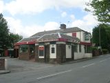
Template:PnItemTop [[File:|thumb|right|500px|The Robin Hood – Church Road / Betty Longbottom, 18 July, 2009, Creative Commons, via Geograph.]]
By Henrik Thiil Nielsen, 2013-08-07. Revised by Henrik Thiil Nielsen, 2019-04-21.
The Robin Hood on Church Road in Altofts, not far from Wakefield, has been a locally owned community pub since 2015,[1] but it is not clear when it was established. It is not included in any of the O.S. maps listed below.
Gazetteers
- Not included in Dobson, R. B., ed.; Taylor, J., ed. Rymes of Robyn Hood: an Introduction to the English Outlaw (London, 1976), pp. 293-311.
Maps
- 25" O.S. map Yorkshire CCXXXIV.13 (1892; surveyed 1890)
- 25" O.S. map Yorkshire CCXXXIV.13 (1908; rev. 1905) (georeferenced)
- 25" O.S. map Yorkshire CCXXXIV.13 (1908; rev. 1905)
- 25" O.S. map Yorkshire CCXXXIV.13 (1933; rev. 1932)
- 6" O.S. map Yorkshire 234 (1852; surveyed 1846-48)
- 6" O.S. map Yorkshire CCXXXIV.SW (1894; surveyed 1890)
- 6" O.S. map Yorkshire CCXXXIV.SW (1908; rev. 1905) (georeferenced)
- 6" O.S. map Yorkshire CCXXXIV.SW (1908; rev. 1905)
- 6" O.S. map Yorkshire CCXXXIV.SW (1932; rev. 1932)
- 6" O.S. map Yorkshire CCXXXIV.SW (1944; rev. 1938)
- 6" O.S. map Yorkshire CCXXXIV.SW (1949; rev. 1948).
Background
The Robin Hood – Church Road / Betty Longbottom, 18 July, 2009, Creative Commons, via Geograph.
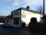
The Robin Hood, Altofts / JThomas, 17 Dec. 2011, Creative Commons, via Geograph.
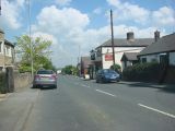
The Robin Hood Pub, Altofts / Bill Henderson, 1 June 2007, Creative Commons, via Geograph.
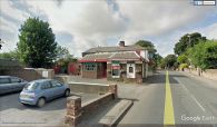
The Robin Hood, Altofts / Google Earth Street View


