
Robin Hood (Altofts): Difference between revisions
From International Robin Hood Bibliography
mNo edit summary |
mNo edit summary |
||
| Line 1: | Line 1: | ||
__NOTOC__{{PnItemTop|Lat=53.706852|Lon=-1.439008|AdmDiv=Yorkshire|Vicinity=10 Church Road, Normanton|Type=Public house|Interest=Robin Hood name|Status=Extant|Demonym=|Riding=West|GreaterLondon=|Year=|Aka=|Century=|Cluster1=|Cluster2=|Cluster3=|Image=Geograph-1405439-by-Betty-Longbottom.jpg|Postcards=|ExtraCat1=|ExtraCat2=|ExtraCat3=|ExtraCat4=|ExtraCat5=|GeopointPrefix=|GeopointSuffix=|StatusSuffix=|DatePrefix=|DateSuffix=?}} | __NOTOC__{{PnItemTop|Lat=53.706852|Lon=-1.439008|AdmDiv=Yorkshire|Vicinity=10 Church Road, Altofts, Normanton|Type=Public house|Interest=Robin Hood name|Status=Extant|Demonym=|Riding=West|GreaterLondon=|Year=|Aka=|Century=|Cluster1=|Cluster2=|Cluster3=|Image=Geograph-1405439-by-Betty-Longbottom.jpg|Postcards=|ExtraCat1=|ExtraCat2=|ExtraCat3=|ExtraCat4=|ExtraCat5=|GeopointPrefix=|GeopointSuffix=|StatusSuffix=|DatePrefix=|DateSuffix=?}} | ||
[[File:{{#var:Pnimage}}|thumb|right|500px|The Robin Hood – Church Road / [https://www.geograph.org.uk/photo/1405439 Betty Longbottom, 18 July, 2009, Creative Commons, via Geograph.]]] | [[File:{{#var:Pnimage}}|thumb|right|500px|The Robin Hood – Church Road / [https://www.geograph.org.uk/photo/1405439 Betty Longbottom, 18 July, 2009, Creative Commons, via Geograph.]]] | ||
{{#display_map:53.7068520,-1.439008|width=34%|service=leaflet|enablefullscreen=yes}}<div class="pnMapLegend">The Robin Hood.</div> | {{#display_map:53.7068520,-1.439008|width=34%|service=leaflet|enablefullscreen=yes}}<div class="pnMapLegend">The Robin Hood.</div> | ||
Revision as of 13:40, 21 April 2019
Template:PnItemTop [[File:|thumb|right|500px|The Robin Hood – Church Road / Betty Longbottom, 18 July, 2009, Creative Commons, via Geograph.]]
The Robin Hood.
By Henrik Thiil Nielsen, 2013-08-07. Revised by Henrik Thiil Nielsen, 2019-04-21.
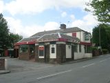
The Robin Hood – Church Road / Betty Longbottom, 18 July, 2009, Creative Commons, via Geograph.
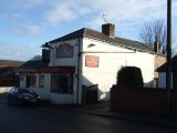
The Robin Hood, Altofts / JThomas, 17 Dec. 2011, Creative Commons, via Geograph.
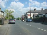
The Robin Hood Pub, Altofts / Bill Henderson, 1 June 2007, Creative Commons, via Geograph.


