Robin Hood's Well (Sawley): Difference between revisions
m (Text replacement - "{{#ask:[[Category:Records ({{#ifeq:{{#pos:{{PAGENAME}}|(|}}||{{PAGENAME}}|{{#sub:{{PAGENAME}}|0| {{#expr:{{#pos:{{PAGENAME}}|(|}}-1}} }},{{#sub:{{PAGENAME}}|{{#expr:{{#pos:{{PAGENAME}}|(|}}-1}}|1}}{{#sub:{{PAGENAME}}|{{#expr:{{#pos:...) |
m (Text replacement - "{{#display_map:{{#var:Coords}}~{{#replace:{{PAGENAME}}|'|'}}|width=34%}}<div class="pnMapLegend">" to "{{#display_map:{{#var:Coords}}~{{#replace:{{PAGENAME}}|'|'}}|width=34%|service=leaflet}}<div class="pnMapLegend">") |
||
| Line 1: | Line 1: | ||
__NOTOC__{{PnItemTop|Lat=53.915327|Lon=-2.340405|AdmDiv=Yorkshire|Vicinity=Grounds of Riverside Care Centre, Smiley Old Brow, Sawley; immediately north of site of Sawley Abbey|Type=Natural feature|Interest=Robin Hood name|Status=Defunct|Demonym=|Riding=West|GreaterLondon=|Year=1850|Aka=|Century=|Cluster1=|Cluster2=|Cluster3=|Image=robin-hoods-well-sawley-google-earth-street-view.jpg|Postcards=|ExtraCat1=Places named Robin Hood's Well|ExtraCat2=|ExtraCat3=|ExtraCat4=|ExtraCat5=|GeopointPrefix=|GeopointSuffix=|StatusSuffix=|DatePrefix=|DateSuffix=}} | __NOTOC__{{PnItemTop|Lat=53.915327|Lon=-2.340405|AdmDiv=Yorkshire|Vicinity=Grounds of Riverside Care Centre, Smiley Old Brow, Sawley; immediately north of site of Sawley Abbey|Type=Natural feature|Interest=Robin Hood name|Status=Defunct|Demonym=|Riding=West|GreaterLondon=|Year=1850|Aka=|Century=|Cluster1=|Cluster2=|Cluster3=|Image=robin-hoods-well-sawley-google-earth-street-view.jpg|Postcards=|ExtraCat1=Places named Robin Hood's Well|ExtraCat2=|ExtraCat3=|ExtraCat4=|ExtraCat5=|GeopointPrefix=|GeopointSuffix=|StatusSuffix=|DatePrefix=|DateSuffix=}} | ||
{{#display_map:{{#var:Coords}}~{{#replace:{{PAGENAME}}|'|'}}|width=34%}}<div class="pnMapLegend">The site of Robin Hood's Well.</div> | {{#display_map:{{#var:Coords}}~{{#replace:{{PAGENAME}}|'|'}}|width=34%|service=leaflet}}<div class="pnMapLegend">The site of Robin Hood's Well.</div> | ||
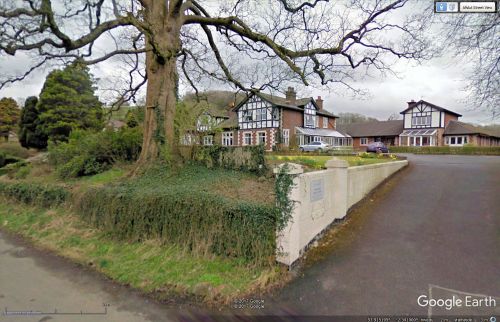
[[File:robin-hoods-well-sawley-google-earth-street-view.jpg|thumb|right|500px|Riverside Care Centre within whose grounds the well must have been located / Google Earth Street View.]] | [[File:robin-hoods-well-sawley-google-earth-street-view.jpg|thumb|right|500px|Riverside Care Centre within whose grounds the well must have been located / Google Earth Street View.]] | ||
<p id="byline">By Henrik Thiil Nielsen, 2017-09-25. Revised by {{#realname:{{REVISIONUSER}}}}, {{REVISIONYEAR}}-{{REVISIONMONTH}}-{{REVISIONDAY2}}.</p> | <p id="byline">By Henrik Thiil Nielsen, 2017-09-25. Revised by {{#realname:{{REVISIONUSER}}}}, {{REVISIONYEAR}}-{{REVISIONMONTH}}-{{REVISIONDAY2}}.</p> | ||
Revision as of 08:59, 5 April 2019
By Henrik Thiil Nielsen, 2017-09-25. Revised by Henrik Thiil Nielsen, 2019-04-05.
Robin Hood's Well immediately north of the site of Sawley Abbey is included on at least three O.S. maps dating from the period 1850–90 (see Maps section below). The well was in an area overlooking the Ribble and now occupied by Riverside Care Centre, a home for people with dementia.[1] A recent English Heritage report on Sawley Abbey notes that the manner in which the well is indicated on the 1850 O.S. map "suggests that it was not thought to be of historical interest or of any great antiquity" and that "the annotation ‘Robin Hood’s Well’ [...] does not appear to relate to any specific place".[2] I believe the latter is an indication that it was a seepage or filtration spring, whose area would not be as clearly defined as those of other types of spring.[3] Formerly belonging to the West Riding of Yorkshire, Sawley is now part of Lancashire. Template:PnItemQry
Gazetteers
- Not included in Dobson, R. B., ed.; Taylor, J., ed. Rymes of Robyn Hood: an Introduction to the English Outlaw (London, 1976), pp. 293-311.
Maps
Robin Hood's Well only included on 25" O.S. map of 1886 and 6" maps of 1850 and 1890.
- 25" O.S. map Yorkshire CLXXXII.4 (1886; surveyed 1884)
- 25" O.S. map Yorkshire CLXXXII.4 (1908; surveyed 1907)
- 6" O.S. map Yorkshire 182 (1850; surveyed 1847)
- 6" O.S. map Yorkshire CLXXXII (1890; surveyed 1884)
- 6" O.S. map Yorkshire CLXXXii.NE (1910; rev. 1907)
- 6" O.S. map Yorkshire CLXXXii.NE (1910; rev. 1907) (georeferenced).
Discussion
Background
- Riverside Care Centre
- Wikipedia: Sawley
- Wikipedia: Seepage (hydrology)
- Wikipedia: Spring (hydrology).
Notes
- ↑ Riverside Care Centre.
- ↑ IRHB's brackets. Hunt, Abby; Pollington, Mitchell; Dunn, Christopher; Pearson, Trevor. Sawley Abbey, Sawley, Lancashire: A Cistercian Monastic Precinct and Post-Medieval Landscape (Survey Report: Arcaheological Investigation Report Series A1, No. 17) (Swindon, ©2005), p. 13.
- ↑ Wikipedia: Seepage (hydrology)]; Wikipedia: Spring (hydrology).]

