
Robin Hood's Well (Pendle Hill)
| Locality | |
|---|---|
| Coordinate | 53.875, -2.2954 |
| Adm. div. | Lancashire |
| Vicinity | On N slope of Pendle Hill, above Ravens Holme |
| Type | Natural feature |
| Interest | Robin Hood name |
| Status | Defunct |
| First Record | 1925 |

By Henrik Thiil Nielsen, 2019-02-23. Revised by Henrik Thiil Nielsen, 2021-02-13.
Around 1925 a well on the northern slope of Pendle Hill was referred to as 'Robin Hood's Well'. Its exact location is no longer known.
The well is mentioned twice by a writer of local ramblers' guides (see Allusions below). These passages suggest that the well was situated above Ravens Holme on the northern slope of the hill, on Downham Moor or the piece of land labelled "Great Coppy" on the O.S. maps listed below.
Allusions
1925 - Bates, Joe - Rambles around Pendle
From the far edge, above Robin Hood's Well, vou look down on Pendle Bridge; the clough below is Ravensholme; lower down still you see Hill Foot, Higson, and beyond, the roofs of Rimington. Coming west the gaze rests on Worston, Warsaw Hill, Downham and the Ribble below Sawley.[1]
1926 - Bates, Joe - Rambles twix Pendle and Holme (1)
At the far end of the summit [of Pendle Hill], going north, is a wall; in the wall is a good stone step-up stile; over the stile a path leads down to Robin Hood's well. From this particular point the view is enchanting, embracing the wide Ribble Valley, the Bowland Fells, the towering Yorkshire mountains, Longridge, Kemple End on the [p. 15:] far left, and Simon's Seat on the extreme right. No scene in the whole wide world so appeals to the heart of the Pendle Forester as do the views seen from the top of Pendle.
There is a choice of three ways down from the top of Pendle: the cart road, easy and safe; the side path starting near to the stile in the wall, steep and slippery, but most used; or straight down the face of the hill.[2]
Gazetteers
- Not included in Dobson, R. B., ed.; Taylor, J., ed. Rymes of Robyn Hood: an Introduction to the English Outlaw (London, 1976), pp. 293-311.
Maps
- 25" O.S. map Lancashire XLVIII.9 (c. 1894; surveyed c. 1891). No copy in NLS
- 25" O.S. map Lancashire XLVIII.9 (1912; rev. 1910) (georeferenced)
- 25" O.S. map Lancashire XLVIII.9 (1912; rev. 1910)
- 25" O.S. map Lancashire XLVIII.9 (1932; rev. 1930)
- 6" O.S. map Lancashire XLVIII (1848; surveyed 1844)
- 6" O.S. map Yorkshire CLXXXIII.SW (1896; surveyed 1893)
- 6" O.S. map Lancashire XLVIII.SW (1914; rev. 1910) (georeferenced)
- 6" O.S. map Yorkshire CLXXXIII.SW (1911; rev. 1907).
Brief mention
Notes
Image gallery
Click any image to display it in the lightbox, where you can navigate between images by clicking in the right or left side of the current image.
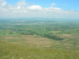
Looking north-east from Pendle Hill; Robin Hood's Well must have been located somewhere on this slope / John Topping, 9 Jun. 2008, Creative Commons, via Geograph.
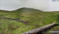
Looking up at the northern slope of Pendle Hill / Google Earth Street View.
