
Robin Hood's Well (Pendle Hill): Difference between revisions
m (Text replacement - "|service=leaflet}}" to "|service=leaflet|enablefullscreen=yes}}") |
m (Text replacement - "Creative Commons via Geograph" to "Creative Commons, via Geograph") |
||
| Line 2: | Line 2: | ||
Status=Defunct|Demonym=|Riding=|GreaterLondon=|Year=1925|Aka=|Century=|Cluster1=|Cluster2=|Cluster3=|Image=geograph-2905339-by-John-Topping.jpg|Postcards=|ExtraCat1=|ExtraCat2=|ExtraCat3=|ExtraCat4=|ExtraCat5=|ExtraLink1=|ExtraLink2=|ExtraLink3=|ExtraLink4=|ExtraLink5=|ExtraLinkName1=|ExtraLinkName2=|ExtraLinkName3=|ExtraLinkName4=|ExtraLinkName5=|GeopointPrefix=|GeopointSuffix=|VicinitySuffix=|StatusSuffix=|DatePrefix=|DateSuffix=}} | Status=Defunct|Demonym=|Riding=|GreaterLondon=|Year=1925|Aka=|Century=|Cluster1=|Cluster2=|Cluster3=|Image=geograph-2905339-by-John-Topping.jpg|Postcards=|ExtraCat1=|ExtraCat2=|ExtraCat3=|ExtraCat4=|ExtraCat5=|ExtraLink1=|ExtraLink2=|ExtraLink3=|ExtraLink4=|ExtraLink5=|ExtraLinkName1=|ExtraLinkName2=|ExtraLinkName3=|ExtraLinkName4=|ExtraLinkName5=|GeopointPrefix=|GeopointSuffix=|VicinitySuffix=|StatusSuffix=|DatePrefix=|DateSuffix=}} | ||
{{#display_map:{{#var:Coords}}~{{#replace:{{PAGENAME}}|'|'}}|width=34%|service=leaflet|enablefullscreen=yes}}<div class="pnMapLegend">Possible site of Robin Hood's Well.</div> | {{#display_map:{{#var:Coords}}~{{#replace:{{PAGENAME}}|'|'}}|width=34%|service=leaflet|enablefullscreen=yes}}<div class="pnMapLegend">Possible site of Robin Hood's Well.</div> | ||
[[File:{{#var:Pnimage}}|thumb|right|500px|Looking north-east from Pendle Hill; Robin Hood's Well must have been located somewhere on this slope / [https://www.geograph.org.uk/photo/2905339 John Topping, 9 Jun. 2008, Creative Commons via Geograph.]]] | [[File:{{#var:Pnimage}}|thumb|right|500px|Looking north-east from Pendle Hill; Robin Hood's Well must have been located somewhere on this slope / [https://www.geograph.org.uk/photo/2905339 John Topping, 9 Jun. 2008, Creative Commons, via Geograph.]]] | ||
<p id="byline">By Henrik Thiil Nielsen, 2019-02-23. Revised by {{#realname:{{REVISIONUSER}}}}, {{REVISIONYEAR}}-{{REVISIONMONTH}}-{{REVISIONDAY2}}.</p><div class="no-img"> | <p id="byline">By Henrik Thiil Nielsen, 2019-02-23. Revised by {{#realname:{{REVISIONUSER}}}}, {{REVISIONYEAR}}-{{REVISIONMONTH}}-{{REVISIONDAY2}}.</p><div class="no-img"> | ||
Around 1925 a well on the northern slope of Pendle Hill was referred to as 'Robin Hood's Well'. Its exact location is no longer known. | Around 1925 a well on the northern slope of Pendle Hill was referred to as 'Robin Hood's Well'. Its exact location is no longer known. | ||
| Line 37: | Line 37: | ||
{{ImgGalleryIntro}} | {{ImgGalleryIntro}} | ||
<gallery widths="195px"> | <gallery widths="195px"> | ||
File:geograph-2905339-by-John-Topping.jpg|Looking north-east from Pendle Hill; Robin Hood's Well must have been located somewhere on this slope / [https://www.geograph.org.uk/photo/2905339 John Topping, 9 Jun. 2008, Creative Commons via Geograph.] | File:geograph-2905339-by-John-Topping.jpg|Looking north-east from Pendle Hill; Robin Hood's Well must have been located somewhere on this slope / [https://www.geograph.org.uk/photo/2905339 John Topping, 9 Jun. 2008, Creative Commons, via Geograph.] | ||
File:robin-hoods-well-pendle-hill-google-earth-street-view.jpg|Looking up at the northern slope of Pendle Hill / Google Earth Street View. | File:robin-hoods-well-pendle-hill-google-earth-street-view.jpg|Looking up at the northern slope of Pendle Hill / Google Earth Street View. | ||
</gallery> | </gallery> | ||
Revision as of 11:23, 30 May 2019
[[File:|thumb|right|500px|Looking north-east from Pendle Hill; Robin Hood's Well must have been located somewhere on this slope / John Topping, 9 Jun. 2008, Creative Commons, via Geograph.]]
By Henrik Thiil Nielsen, 2019-02-23. Revised by Henrik Thiil Nielsen, 2019-05-30.
Around 1925 a well on the northern slope of Pendle Hill was referred to as 'Robin Hood's Well'. Its exact location is no longer known.
The well is mentioned twice by a writer of local ramblers' guides (see Allusions below). These passages suggest that the well was situated above Ravens Holme on the northern slope of the hill, on Downham Moor or the piece of land labelled "Great Coppy" on the O.S. maps listed below. Template:PnItemQry
Gazetteers
- Not included in Dobson, R. B., ed.; Taylor, J., ed. Rymes of Robyn Hood: an Introduction to the English Outlaw (London, 1976), pp. 293-311.
Maps
- 6" O.S. map Lancashire XLVIII (1848; surveyed 1844)
- 6" O.S. map Yorkshire CLXXXIII.SW (1896; surveyed 1893)
- 6" O.S. map Lancashire XLVIII.SW (1914; rev. 1910) (georeferenced)]
- 6" O.S. map Yorkshire CLXXXIII.SW (1911; rev. 1907)
- 25" O.S: map Lancashire XLVIII.9 (c. 1894; surveyed c. 1891). No Copy in NLS
- 25" O.S. map Lancashire XLVIII.9 (1912; rev. 1910) (georeferenced)]
- 25" O.S. map Lancashire XLVIII.9 (1912; rev. 1910)
- 25" O.S. map Lancashire XLVIII.9 (1932; rev. 1930).
Brief mention
Notes
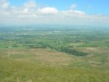
Looking north-east from Pendle Hill; Robin Hood's Well must have been located somewhere on this slope / John Topping, 9 Jun. 2008, Creative Commons, via Geograph.
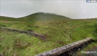
Looking up at the northern slope of Pendle Hill / Google Earth Street View.

