
Robin Hood's Well (Helmshore)
From International Robin Hood Bibliography
| Locality | |
|---|---|
| Coordinate | 53.671858, -2.336613 |
| Adm. div. | Lancashire |
| Vicinity | On Moor Road, c. 2 km S of Helmshore, c. 2 km N of Stubbins |
| Type | Natural feature |
| Interest | Robin Hood name |
| Status | Extant |
| First Record | 1850 |
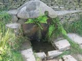
Robin Hood's Well.

Robin Hood's Well / Paul Anderson, 11 Sep. 2007, Creative Commons, via Geograph.
By Henrik Thiil Nielsen, 2014-10-16. Revised by Henrik Thiil Nielsen, 2021-01-07.
This well is situated on Moor Road about midway between Helmshore and Stubbins. John Crawshaw has recently described it as follows:
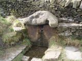
The spring issues out from beneath a large, worn stone capping: shaped rather like a flattened pyramid with a blunt apex. This is set against a dry-stone wall by the side of Stake Lane. The water falls from the well-head into a small pool and the whole arrangement of stones has the appearance of great age.
The flattened-pyramid-shaped piece of sandstone covering the well has several worn, carved indentations upon it, one of which, near the left-hand side at the front is a wide groove. It is possible that this was made by the wearing down of the stone by a chain securing a drinking cup at its end. However, no trace of any chain or cup can now be discerned.[1]
'Stake Lane' is or was the local name for a stretch of Moor Road.[2] The well is indicated on the 1850 6" O.S. map of the area, based on a survey carried out 1844-47. It is found on all subsequent 6" O.S. map of the area avilable at NLS.[3]The flattened-pyramid-shaped piece of sandstone covering the well has several worn, carved indentations upon it, one of which, near the left-hand side at the front is a wide groove. It is possible that this was made by the wearing down of the stone by a chain securing a drinking cup at its end. However, no trace of any chain or cup can now be discerned.[1]
Allusions
1893 - Elliot, W Hume - Country and Church of Cheeryble Brothers
A few yards down Stake Lane is Robin Hood's Well, with an ancient well-hewn coping-stone over it of ample dimensions.[4]
Gazetteers
- Not included in Dobson, R. B., ed.; Taylor, J., ed. Rymes of Robyn Hood: an Introduction to the English Outlaw (London, 1976), pp. 293-311.
Sources
- Robin Hood's Well, near Helmshore by John Crawshaw
- Dowsett, Henry. Notes on Holcombe (Manchester, 1901), p. 75
- Dowsett, Henry. Holcombe long ago (Manchester, 1902). Not seen.
Maps
- 6" O.S. map Lancashire Sheet LXXIX (1850, surveyed 1844-47)
- 6" O.S. map Lancashire Sheet LXXIX.NE (1894, surveyed 1891)
- 6" O.S. map Lancashire Sheet LXXIX.NE (1912, surveyed 1908)
- 6" O.S. map Lancashire Sheet LXXIX.NE (1930, surveyed 1927)
- 6" O.S. map Lancashire Sheet LXXIX.NE (1947, surveyed 1938).
Discussion
- The Journal of Antiquities: Robin Hood’s Well, Helmshore, Lancashire; by Ray Spencer
- Lancashire Past: Robin Hood’s Well, Helmshore near Bury
- [Sutton, Charles W.], ed. 'Proceedings', Transactions of the Lancashire and Cheshire Antiquarian Society, vol. XXIII (1905), pp. 199-226; see pp. 206-207.
Brief mention
- Farrer, William, ed.; Brownbill, J., ed. The Victoria History of the County of Lancaster (London, 1906), vol. V, p. 144. Web version at British History Online
- [Sutton, Charles W.], ed. 'Visits and Excursions made by the Society in 1905', Transactions of the Lancashire and Cheshire Antiquarian Society, vol. XXIII (1905), p. [iv].
Also see
Notes
- ↑ Robin Hood's Well, near Helmshore by John Crawshaw.
- ↑ The Journal of Antiquities: Robin Hood’s Well, Helmshore, Lancashire; by Ray Spencer.
- ↑ See Maps section.
- ↑ Elliot, W. Hume. The Country and Church of the Cheeryble Brothers (Selkirk, 1893), p. 11.
Image gallery
Click any image to display it in the lightbox, where you can navigate between images by clicking in the right or left side of the current image.
Robin Hood's Well / Paul Anderson, 11 Sep. 2007, Creative Commons, via Geograph.
Robin Hood's Well / Panoramio user 'jolmartyn', 2011.
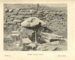
Robin Hood's Well / H. Dowsett's Holcombe long ago (1902) via Ramsbottom Heritage Society.


