
Robin Hood's Well (Helmshore): Difference between revisions
m (→Maps) |
m (→Maps) |
||
| Line 17: | Line 17: | ||
== Maps == | == Maps == | ||
* [http://maps.nls.uk/view/102344000#zoom=6&lat=8150&lon=11858&layers=BT O.S. | * [http://maps.nls.uk/view/102344000#zoom=6&lat=8150&lon=11858&layers=BT 6" O.S. map Lancashire Sheet LXXIX (1850, surveyed 1844-47)] | ||
* [http://maps.nls.uk/view/101102528#zoom=6&lat=4166&lon=5325&layers=BT O.S. | * [http://maps.nls.uk/view/101102528#zoom=6&lat=4166&lon=5325&layers=BT 6" O.S. map Lancashire Sheet LXXIX.NE (1894, surveyed 1891)] | ||
* [http://maps.nls.uk/view/101102525#zoom=6&lat=4150&lon=5183&layers=BT O.S. | * [http://maps.nls.uk/view/101102525#zoom=6&lat=4150&lon=5183&layers=BT 6" O.S. map Lancashire Sheet LXXIX.NE (1912, surveyed 1908)] | ||
* [http://maps.nls.uk/view/101102522#zoom=6&lat=4198&lon=5191&layers=BT O.S. | * [http://maps.nls.uk/view/101102522#zoom=6&lat=4198&lon=5191&layers=BT 6" O.S. map Lancashire Sheet LXXIX.NE (1930, surveyed 1927)] | ||
* [http://maps.nls.uk/view/101102519#zoom=6&lat=4144&lon=5034&layers=BT O.S. | * [http://maps.nls.uk/view/101102519#zoom=6&lat=4144&lon=5034&layers=BT 6" O.S. map Lancashire Sheet LXXIX.NE (1947, surveyed 1938).] | ||
== Discussion == | == Discussion == | ||
Revision as of 12:55, 31 May 2019
[[File:|thumb|right|500px|Robin Hood's Well / Paul Anderson, 11 Sep. 2007, Creative Commons, via Geograph.]]
By Henrik Thiil Nielsen, 2014-10-16. Revised by Henrik Thiil Nielsen, 2019-05-31.
This well is situated on Moor Road about midway between Helmshore and Stubbins. John Crawshaw has recently described it as follows:
The flattened-pyramid-shaped piece of sandstone covering the well has several worn, carved indentations upon it, one of which, near the left-hand side at the front is a wide groove. It is possible that this was made by the wearing down of the stone by a chain securing a drinking cup at its end. However, no trace of any chain or cup can now be discerned.[1]
'Stake Lane' is or was the local name for a stretch of Moor Road.[2] The well is indicated on the 1850 6" O.S. map of the area, based on a survey carried out 1844-47. It is found on all subsequent 6" O.S. map of the area avilable at NLS.[3]Template:PnItemQry
Gazetteers
- Not included in Dobson, R. B., ed.; Taylor, J., ed. Rymes of Robyn Hood: an Introduction to the English Outlaw (London, 1976), pp. 293-311.
Sources
- Robin Hood's Well, near Helmshore by John Crawshaw
- Dowsett, Henry. Notes on Holcombe (Manchester, 1901), p. 75
- Dowsett, Henry. Holcombe long ago (Manchester, 1902). Not seen.
Maps
- 6" O.S. map Lancashire Sheet LXXIX (1850, surveyed 1844-47)
- 6" O.S. map Lancashire Sheet LXXIX.NE (1894, surveyed 1891)
- 6" O.S. map Lancashire Sheet LXXIX.NE (1912, surveyed 1908)
- 6" O.S. map Lancashire Sheet LXXIX.NE (1930, surveyed 1927)
- 6" O.S. map Lancashire Sheet LXXIX.NE (1947, surveyed 1938).
Discussion
- The Journal of Antiquities: Robin Hood’s Well, Helmshore, Lancashire; by Ray Spencer
- Lancashire Past: Robin Hood’s Well, Helmshore near Bury
- [Sutton, Charles W.], ed. 'Proceedings', Transactions of the Lancashire and Cheshire Antiquarian Society, vol. XXIII (1905), pp. 199-226; see pp. 206-207.
Brief mention
- Farrer, William, ed.; Brownbill, J., ed. The Victoria History of the County of Lancaster (London, 1906), vol. V, p. 144. Web version at British History Online
- [Sutton, Charles W.], ed. 'Visits and Excursions made by the Society in 1905', Transactions of the Lancashire and Cheshire Antiquarian Society, vol. XXIII (1905), p. [iv].
Notes
- ↑ Robin Hood's Well, near Helmshore by John Crawshaw.
- ↑ The Journal of Antiquities: Robin Hood’s Well, Helmshore, Lancashire; by Ray Spencer.
- ↑ See Maps section.
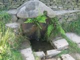
Robin Hood's Well / Paul Anderson, 11 Sep. 2007, Creative Commons, via Geograph.
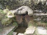
Robin Hood's Well / Panoramio user 'jolmartyn', 2011.
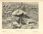
Robin Hood's Well / H. Dowsett's Holcombe long ago (1902) via Ramsbottom Heritage Society.


