
Robin Hood's Well (Helmshore): Difference between revisions
m (Text replacement - "|service=leaflet}}" to "|service=leaflet|enablefullscreen=yes}}") |
m (Text replacement - "Creative Commons via Geograph" to "Creative Commons, via Geograph") |
||
| Line 1: | Line 1: | ||
__NOTOC__{{PnItemTop|Lat=53.671858|Lon=-2.336613|AdmDiv=Lancashire|Vicinity=On Moor Road, c. 2 km S of Helmshore, c. 2 km N of Stubbins|Type=Natural feature|Interest=Robin Hood name|Status=Extant|Demonym=|Riding=|GreaterLondon=|Year=1850|Aka=|Century=|Cluster1=Helmshore|Cluster2=|Cluster3=|Image=Rhs well stubbins lancs paul anderson.jpg|Postcards=|ExtraCat1=Places named Robin Hood's Well|ExtraCat2=|ExtraCat3=|ExtraCat4=|ExtraCat5=|ExtraLink1=|ExtraLink2=|ExtraLink3=|ExtraLink4=|ExtraLink5=|ExtraLinkName1=|ExtraLinkName2=|ExtraLinkName3=|ExtraLinkName4=|ExtraLinkName5=|GeopointPrefix=|GeopointSuffix=|StatusSuffix=|DatePrefix=|DateSuffix=}} | __NOTOC__{{PnItemTop|Lat=53.671858|Lon=-2.336613|AdmDiv=Lancashire|Vicinity=On Moor Road, c. 2 km S of Helmshore, c. 2 km N of Stubbins|Type=Natural feature|Interest=Robin Hood name|Status=Extant|Demonym=|Riding=|GreaterLondon=|Year=1850|Aka=|Century=|Cluster1=Helmshore|Cluster2=|Cluster3=|Image=Rhs well stubbins lancs paul anderson.jpg|Postcards=|ExtraCat1=Places named Robin Hood's Well|ExtraCat2=|ExtraCat3=|ExtraCat4=|ExtraCat5=|ExtraLink1=|ExtraLink2=|ExtraLink3=|ExtraLink4=|ExtraLink5=|ExtraLinkName1=|ExtraLinkName2=|ExtraLinkName3=|ExtraLinkName4=|ExtraLinkName5=|GeopointPrefix=|GeopointSuffix=|StatusSuffix=|DatePrefix=|DateSuffix=}} | ||
{{#display_map:{{#var:Coords}}~{{#replace:{{PAGENAME}}|'|'}}|width=34%|service=leaflet|enablefullscreen=yes}}<div class="pnMapLegend">Robin Hood's Well.</div> | {{#display_map:{{#var:Coords}}~{{#replace:{{PAGENAME}}|'|'}}|width=34%|service=leaflet|enablefullscreen=yes}}<div class="pnMapLegend">Robin Hood's Well.</div> | ||
[[File:{{#var:Pnimage}}|thumb|right|500px|Robin Hood's Well / [http://www.geograph.org.uk/photo/553378 Paul Anderson, 11 Sep. 2007, Creative Commons via Geograph.]]] | [[File:{{#var:Pnimage}}|thumb|right|500px|Robin Hood's Well / [http://www.geograph.org.uk/photo/553378 Paul Anderson, 11 Sep. 2007, Creative Commons, via Geograph.]]] | ||
<p id="byline">By Henrik Thiil Nielsen, 2014-10-16. Revised by {{#realname:{{REVISIONUSER}}}}, {{REVISIONYEAR}}-{{REVISIONMONTH}}-{{REVISIONDAY2}}.</p> | <p id="byline">By Henrik Thiil Nielsen, 2014-10-16. Revised by {{#realname:{{REVISIONUSER}}}}, {{REVISIONYEAR}}-{{REVISIONMONTH}}-{{REVISIONDAY2}}.</p> | ||
<div class="no-img"> | <div class="no-img"> | ||
| Line 39: | Line 39: | ||
{{ImgGalleryIntro}} | {{ImgGalleryIntro}} | ||
<gallery widths="195px"> | <gallery widths="195px"> | ||
File:Rhs well stubbins lancs paul anderson.jpg|Robin Hood's Well / [http://www.geograph.org.uk/photo/553378 Paul Anderson, 11 Sep. 2007, Creative Commons via Geograph.] | File:Rhs well stubbins lancs paul anderson.jpg|Robin Hood's Well / [http://www.geograph.org.uk/photo/553378 Paul Anderson, 11 Sep. 2007, Creative Commons, via Geograph.] | ||
File:RH's Well Stubbins jolmartyn.jpg|Robin Hood's Well / [http://www.panoramio.com/photo/48818638 Panoramio user 'jolmartyn', 2011.] | File:RH's Well Stubbins jolmartyn.jpg|Robin Hood's Well / [http://www.panoramio.com/photo/48818638 Panoramio user 'jolmartyn', 2011.] | ||
File:DOW-000-005.jpg|thumb|right|460px|Robin Hood's Well / [[Dowsett, Henry 1902a|H. Dowsett's ''Holcombe long ago'' (1902)]] via [http://www.ramsbottomheritage.org.uk/cpg/displayimage.php?album=29&pos=37 Ramsbottom Heritage Society.] | File:DOW-000-005.jpg|thumb|right|460px|Robin Hood's Well / [[Dowsett, Henry 1902a|H. Dowsett's ''Holcombe long ago'' (1902)]] via [http://www.ramsbottomheritage.org.uk/cpg/displayimage.php?album=29&pos=37 Ramsbottom Heritage Society.] | ||
Revision as of 11:23, 30 May 2019
[[File:|thumb|right|500px|Robin Hood's Well / Paul Anderson, 11 Sep. 2007, Creative Commons, via Geograph.]]
By Henrik Thiil Nielsen, 2014-10-16. Revised by Henrik Thiil Nielsen, 2019-05-30.
This well is situated on Moor Road about midway between Helmshore and Stubbins. John Crawshaw has recently described it as follows:
The flattened-pyramid-shaped piece of sandstone covering the well has several worn, carved indentations upon it, one of which, near the left-hand side at the front is a wide groove. It is possible that this was made by the wearing down of the stone by a chain securing a drinking cup at its end. However, no trace of any chain or cup can now be discerned.[1]
'Stake Lane' is or was the local name for a stretch of Moor Road.[2] The well is indicated on the 1850 6" O.S. map of the area, based on a survey carried out 1844-47. It is found on all subsequent 6" O.S. map of the area avilable at NLS.[3]Template:PnItemQry
Gazetteers
- Not included in Dobson, R. B., ed.; Taylor, J., ed. Rymes of Robyn Hood: an Introduction to the English Outlaw (London, 1976), pp. 293-311.
Sources
- Robin Hood's Well, near Helmshore by John Crawshaw.
- Dowsett, Henry. Notes on Holcombe (Manchester, 1901), p. 75.
- Dowsett, Henry. Holcombe long ago (Manchester, 1902). Not seen
Maps
- O.S. 6" map Lancashire Sheet LXXIX (1850, surveyed 1844-47) (at NLS)
- O.S. 6" map Lancashire Sheet LXXIX.NE (1894, surveyed 1891) (at NLS)
- O.S. 6" map Lancashire Sheet LXXIX.NE (1912, surveyed 1908) (at NLS)
- O.S. 6" map Lancashire Sheet LXXIX.NE (1930, surveyed 1927) (at NLS)
- O.S. 6" map Lancashire Sheet LXXIX.NE (1947, surveyed 1938) (at NLS)
Discussion
- The Journal of Antiquities: Robin Hood’s Well, Helmshore, Lancashire; by Ray Spencer
- Lancashire Past: Robin Hood’s Well, Helmshore near Bury
- [Sutton, Charles W.], ed. 'Proceedings', Transactions of the Lancashire and Cheshire Antiquarian Society, vol. XXIII (1905), pp. 199-226; see pp. 206-207.
Brief mention
- Farrer, William, ed.; Brownbill, J., ed. The Victoria History of the County of Lancaster (London, 1906), vol. V, p. 144. Web version at British History Online
- [Sutton, Charles W.], ed. 'Visits and Excursions made by the Society in 1905', Transactions of the Lancashire and Cheshire Antiquarian Society, vol. XXIII (1905), p. [iv].
Notes
- ↑ Robin Hood's Well, near Helmshore by John Crawshaw.
- ↑ The Journal of Antiquities: Robin Hood’s Well, Helmshore, Lancashire; by Ray Spencer.
- ↑ See Maps section.
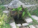
Robin Hood's Well / Paul Anderson, 11 Sep. 2007, Creative Commons, via Geograph.
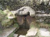
Robin Hood's Well / Panoramio user 'jolmartyn', 2011.
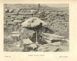
Robin Hood's Well / H. Dowsett's Holcombe long ago (1902) via Ramsbottom Heritage Society.


