
Robin Hood's Well (Barnsdale)
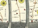
[[File:|500px|right|thumb|Robin Hood's Well – hamlet as well as well – with Robin Hood Inn across the Great North Road / 6" O.S, Map Sheet 264 (1854), at NLS.]]


By Henrik Thiil Nielsen, 2013-06-13. Revised by Henrik Thiil Nielsen, 2018-01-07.
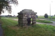
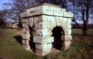
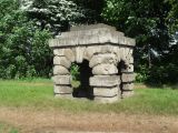
Robin Hood's Well is the name of a well in Barnsdale, at the northwest end of Skellow between the villages of Skelbrooke and Burghwallis, immediately east of the A1 between the Red House junction and Barnsdale Bar. The name now generally refers to the well-house, designed by John Vanbrugh (1664-1726)[1] and constructed over the natural well in the early 18th century but moved to a position near a lay-by a few meters south-east around 1960, when the dual carriageway was constructed. The well-spring is now submerged underneath the A1.[2] A.H. Smith[3] and Dobson & Taylor[4] seem to regard Robin Hood's Well and Robin Hood's Stone (see 1422 record below) as two names for one locality. It is unclear if this was in fact the case, but if distinct, the two localities cannot have been far apart. During the 17th and 18th centuries, the well was one of the "must-see" sites for tourists and travellers along the Great North Road.
While the name Robin Hood's Well can thus refer to both the natural well and the well-house now separated from it, it also, until the early 1930s if not later, referred to the now largely vanished hamlet that grew up around the site, complete with two good inns to serve the sightseeing travellers. One of the inns was named Robin Hood Inn. Of the six 6" O.S. maps of the area available on NLS's excellent maps and images sub-site only the oldest, published in 1854 but based on a survey done in 1849, has both the well and the hamlet indicated by name (see maps listed below). On the other hand, the three 25" maps of the area available there, the latest of which was published in 1932, do indicate both as 'Robin Hood's Well'. It is hard to tell from the maps, therefore, how long the name continued to be used of the hamlet. Perhaps it still is in local use?
Joseph Hunter writes in his discussion of the township of Skellow in his South Yorkshire that "the name is, no doubt, derived from the famous Skel in its neighbourhood, now called Robin Hood's Well"[5] The noun 'well' is sometimes found used with reference to a stream.[6] but I have found no other evidence that the name "Robin Hood's Well" was ever applied to the Skell. In a short part of its course the Skell formed the northern boundary of the hamlet of Robin Hood's Well, immediately before flowing under the Great North Road (now the A1) and past the Bishop's Tree, another Robin Hood-related site. Somewhere in the immediate vicinity was Robin Hood Close. Passing these localities so closely connected with the outlaw and running through southern parts of Barnsdale, the little river may well occasionally, as it were, have borrowed the name of the famous Well.
As just noted, Robin Hood's Well is close to the site of the Bishop's Tree, sometimes referred to as Robin Hood's Tree, a now vanished tree around which Robin Hood made the bishop of Hereford dance, according to the ballad that details their meeting.[7] John Cosin[8] (1594-1672), bishop of Durham (1660-72), distributed alms to the poor in the hamlet of Robin Hood's Well in 1667. We know this from a matter-of-fact entry in the accounts of his travel expenses (see allusion cited below), and there is no reason to think this was other than a routine dole-out, but one can appreciate the irony of the situation nonetheless.
As is clear from S.H. Grimm's 1737 drawing and that in Joseph Hunter's 1828 work on South Yorkshire, the well house was originally considerably taller than it is at present. According to S.R. Clarke (see 1828 Allusion below), the well house was nine feet high. Just why it had to have the lower part of its legs amputated (or buried in the ground) is not clear. Did this happen in 1960 when it was moved to its present location?
To appreciate the importance of Barnsdale to the Robin Hood tradition I recommend reading the entries on Barnsdale and the Robin Hood-related localitites in its vicinity. See the page on the Barnsdale place-name cluster for links.
Records
1422 - Stone of Robert Hode
[1422:]
Grant1 by John Jubbe of Wrangbrok and Richard Jubbe of Upton to John Pullene of Wrangbrok of a tenement in Wrangbrok built on as it lies between the cottage of the nuns of Hampole on the west and the land of Peter de la Hay on the east, and extends to the beck of the said vill towards the south, together with twelve acres of arable land lying in (fo. 182d) the fields and territory of Wrangbrok, Slepill, and Skelbrok; whereof one acre lies in Haverlands between the land of John Bargan on the north and the land of the monks of Bretton on the south, and a rood of land lies in the same field between the land of the John Jubbe on the west and the land of John Wodward on the east, another half acre lies in Mykilffurland between the land of William Lord on the west and the land of the said monks on the east, one rood lies in the same culture between the land of the said monks on the west and the land of William Shepherd on the east, another half acre lies in Le Estfeld between the land of William Bargan on either side, and one rood lies in the same culture between the land of John Jubbe on the west and the land of the said monks on the east, half a rood lies in the same field between the land of the said monks on either side, one acre [lies] in the same culture between the land of John Haitfeld on the west and the land of John Wodward on the east, half an acre lies in the same culture between the land of William Lord on the west and the land of William Bargan on the east, one acre lies between the land of the said monks on the north and the land of John Adamson on the south, half an acre lies in the same field between the land of William Bargan on the north and the land of the said monks on the south, one acre lies in the same culture between the land of the prioress of Hampall on the north and the land of William Lord on the south, half an acre lies in the same field between the land of the said monks on either side, half an acre lies in Slephill between the land of the said prioress on the west and the land of Richard Slephill on the east and abuts on Lynges of Skelbrok, half an acre lies in the same field between the land of John Adamson on the west and the land of the prioress on the east and abuts on Le Lynges aforesaid, half an acre lies in the same culture between the land of William Lord on the west and the land of Reginald Pullayne on the east and abuts on the aforesaid Lynges and upon the stone of Robert Hode2 towards [p. 106:] the north, an acre (fo.183) lies in the same field between the land of the said prioress on the west and the common land on the east and abuts upon their (the grantors') land towards the north, half an acre lies in the same field between the land of William Calthorn on the south and the land of the lord of Skelbrok on the north and abuts on their (the grantors') land towards the west, half an acre lies in the same field between the land of William Calthorn on the north and the land of the said lord on the north [sic] and abuts on the King's highway towards the east, half an acre lies between the land of William Calthorn on the north and the land of John Janyn on the south and abuts on the same highway to the east.1 To hold and to have to the said John Pulayne for his life, freely, quietly, etc., from the chief lords of that fee, by the services due and accustomed, rendering thence yearly to the lord of Burghwaleis 5d. and to the prior of Bretton 3s. 7d. And after the death of the said John, remainder to John his son and the heirs of his body; and if he shall die without such heir, remainder to the right heirs of John Polayne for ever. Witnesses, John Wentworth of Elmesall, William Lorde of Wrangbrok, Richard de Wrangbrok, and others. Dated at Wrangbrok, Sunday in the feast of Holy Trinity, 1322.2[9]
22
9
Lists
- Dobson, Richard Barrie; ed.; Taylor, John, ed. Rymes of Robyn Hood: an Introduction to the English Outlaw (London, 1976), p. 310 (and see 308).
Sources
- Black, Adam; Black, Charles. Black's Picturesque Guide to Yorkshire (Edinburgh, 1858), pp. 114-15.
- Clarke, Stephen Reynolds. The New Yorkshire Gazetteer, or Topographical Dictionary (London, 1828), p. 208.
- Downes, Kerry. [Letter to the Editor], Country Life (Sep. 17, 1964), p. 709.[10] Discusses the dismantling and subsequent re-erection of the well-house occasioned by the construction of the dual carriageway.
- Smith, A.H. The Place-Names of the West Riding of Yorkshire (English Place-Name Society, vols. XXX-XXXVII) (Cambridge, 1961-63), pt. II, pp. 36, 44.
- Stukeley, William; [W.C. Lukis, ed.] The Family Memoirs of the Rev. William Stukeley (The Publications of the Surtees Society, vols. LXXIII, LXXVI, LXXX) (1882-87), vol. III, p. 500.
- White, William, ed. History, Gazetteer, and Diretory, of the West-Riding of Yorkshire, with the City of York and Port of Hull; comprising under a lucid arrangement of subjects, a General Survey of the Riding, and of the Sees of York and Ripon; with Separate Historical, Statistical, and Topographical Descriptions of all the Boroughs, Towns, Parishes, Chapelries, Townships, Villages, Hamlets, Manors, Liberties and Wapentakes; Shewing their Extent and Population; the rise and progress of their Trade and Commerce; their Agricultural and Mineral productions; their Markets and Fairs; the Lords of the Manors and Owners of the Soil and Tithes; their Eminent Men; their Churches, Chapels, Charities, and Public Institutions; the Names and Addresses of their principal Inhabitants; the Seats of Nobility and Gentry; Magistrates and Public Officers; And a Variety of other Commercial, Agricultural, and Statistical Information (Sheffield; Leeds, 1837-38), vol. II, pp. 261, 274.
Maps
- Jefferys, Thomas. Map of Yorkshire (1771-72).[11]
- 25" O.S. map Yorkshire CCLXIV.11 (1893; surveyed 1891)
- 25" O.S. map Yorkshire CCLXIV.11 (1906; surveyed 1904)
- 25" O.S. map Yorkshire CCLXIV.11 (1932; surveyed 1930)
- 6" O.S. Yorkshire 264 (1854, surveyed 1849)
- 6" O.S. Yorkshire CCLXIV.SE (1894, surveyed 1891)
- 6" O.S. Yorkshire CCLXIV.SE (1907, rev. 1904)
- 6" O.S. Yorkshire CCLXIV.SE (1930, rev. 1930)
- 6" O.S. Yorkshire CCLXIV.SE (1950, rev. 1948).
- O.S. 1:25,000 map SE51 (1952).
Drawings
- On September 20, 1725, William Stukeley made a drawing of the well, listed in a catalogue of his papers as "Robin Hood's well, and the Hermen [i.e. Ermine] street, 20 Sept., 1725".[12] The drawing is found in volume 16 of William Stukeley's MS Diary among his papers in the Bodleian Library.[13]
Discussion
- Dobson, R.B.; Taylor, J. 'The Medieval Origins of the Robin Hood Legend: a Reassessment', Northern History, vol. 7 (1972), pp. 1-30, see pp. 18-19.
- Dobson, R. B., ed.; Taylor, J., ed. Rymes of Robyn Hood: an Introduction to the English Outlaw (London, 1976), pp. 23-24.
- Groundwater, Anna. "Robin Hood’s Well" at Ben Jonson's Walk (University of Edinburgh).
- Hope, R C 1892b, see p. 159.
- Hunter, Joseph. South Yorkshire. The History and Topography of the Deanery of Doncaster in the Diocese and County of York (London, 1828-31), vol. II, pp. 487-88.
- Mitchell, W.R. The Haunts of Robin Hood (Clapham via Lancaster, 1970), pp. 25-26.
- "Robin Hood's Well" at Robin Hood: the Facts & the Fiction.
- Wikipedia: Barnsdale.
- 'Robin Hood's Well.
Background
- Bodleian Library: Collection Level Description: Papers of William Stukeley.
- Stukeley, William; [W.C. Lukis, ed.] The Family Memoirs of the Rev. William Stukeley (The Publications of the Surtees Society, vols. LXXIII, LXXVI, LXXX) (1882-87), p. 500, No. 129.
- Wikipedia: John Cosin.
- Wikipedia: John Vanbrugh.
Brief mention
- Hope, R C 1890a.
- Hope, R C 1892a, see p. 28.
Notes
- ↑ Wikipedia: John Vanbrugh.
- ↑ Wikipedia: Barnsdale.
- ↑ Smith, A.H. The Place-Names of the West Riding of Yorkshire (English Place-Name Society, vols. XXX-XXXVII) (Cambridge, 1961-63), pt. II, pp. 36, 44.
- ↑ Dobson, R. B., ed.; Taylor, J., ed. Rymes of Robyn Hood: an Introduction to the English Outlaw (London, 1976), pp. 23-24.
- ↑ Hunter, Joseph. South Yorkshire. The History and Topography of the Deanery of Doncaster in the Diocese and County of York (London, 1828-31), vol. II, pp. 481-82; also see vol. II, p. 457.
- ↑ [OED, s.n. well, n. 1, 1. a.] (requires paid subscription)
- ↑ See Robin Hood and the Bishop of Hereford.
- ↑ Wikipedia: John Cosin.
- ↑ Walker, John William, ed., Abstracts of the Chartularies of the Priory of Monkbretton. Reprinted (Cambridge Library Collection) (Cambridge, 2013), pp. 105-106.
- ↑ Not seen, but cf. Dobson, R.B.; Taylor, J. 'The Medieval Origins of the Robin Hood Legend: a Reassessment', Northern History, vol. 7 (1972), pp. 1-30, p. 18 n. 63.
- ↑ Not seen but cf. A.H. Smith, loc. cit., whose abbreviated reference expands as "Yorkshire (Greenwood) 1771", in all probability a mistake for "Yorkshire (Jefferys) 1772". Both Jefferys and the Greenwood brothers made important maps of the county, but in 1771 the Greenwood brothers were not yet born. Jefferys's map was made in 1771-72 and published in 1772.
- ↑ Stukeley, William; [W.C. Lukis, ed.] The Family Memoirs of the Rev. William Stukeley (The Publications of the Surtees Society, vols. LXXIII, LXXVI, LXXX) (1882-87), p. 500, No. 129.
- ↑ For access etc., see Bodleian Library: Collection Level Description: Papers of William Stukeley.
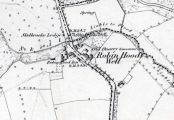
Robin Hood's Well – hamlet as well as well – with Robin Hood Inn across the Great North Road / 6" O.S, Map Sheet 264 (1854), at NLS.
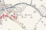
Robin Hood's Well, hamlet and well, in 1891 / 25" O.S. map Yorkshire CCLXIV.11 (1893; surveyed 1891), at NLS.
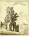
Robin Hood's Well / Samuel Hieronymus Grimm, 1773; Wikimedia Commons.
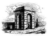
Robin Hood's Well / Joseph Hunter's South Yorkshire (1828).
John Vanbrugh's well-house, now on dry ground / Bill Henderson.
Robin Hood's Well / Roy Pledger, 2011, Google Earth / Panoramio.
Robin Hood's Well / Damon Stead, 2011, Google Earth / Panoramio.
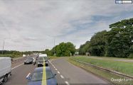
Robin Hood's Well in its setting, from the AI, looking north / Google Earth Street View.
John Ogilby's Britannia (1675), 'The Continuation of the Road from London to Barwick, Beginning at Tuxford. & Extending to York.', Plate 3.3 / The Visual Telling of Stories.

