Robin Hood's Oak (Horksley Heath): Difference between revisions
m (→Quotations) |
mNo edit summary |
||
| Line 1: | Line 1: | ||
__NOTOC__ | __NOTOC__{{PnItemTop|Lat=51.925929|Lon=0.878865|AdmDiv=Essex|Vicinity=On or near Horksley Heath, c. 4 km N of Colchester|Type=Natural feature|Interest=Robin Hood name|Status=Defunct|Demonym=|Riding=|GreaterLondon=|Year=1637|Aka=|Century=|Cluster1=|Cluster2=|Image=Bowen's Map of Colchester.jpg|Postcards=|ExtraCat1=|ExtraCat2=|ExtraCat3=|ExtraCat4=|ExtraCat5=|GeopointPrefix=Near |GeopointSuffix=|VicinitySuffix=|StatusSuffix=|DatePrefix=|DateSuffix=}} | ||
{{ | {{#display_map:{{#var:Coords}}|width=500|height=372|controls=type,streetview|typestyle=dropdown|width=34%}}<div class="pnMapLegend">Probable, approximate location of Robin Hood's Oak.</div> | ||
}} | |||
{{#display_map: | |||
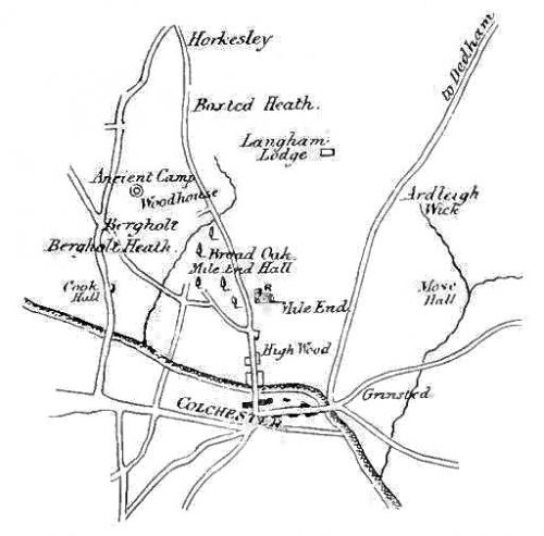
[[File:Bowen's Map of Colchester.jpg|thumb|500px|right|Bowen's map of Colchester, 1760. Robin Hood's Oak may have been one of the large trees indicated halfway between Colchester and Horksley. Only one, the Broad Oak, is named on the map (from [[Harrod, Henry 1865a|Harrod]], p. 24).]] | [[File:Bowen's Map of Colchester.jpg|thumb|500px|right|Bowen's map of Colchester, 1760. Robin Hood's Oak may have been one of the large trees indicated halfway between Colchester and Horksley. Only one, the Broad Oak, is named on the map (from [[Harrod, Henry 1865a|Harrod]], p. 24).]] | ||
<p id="byline">By Henrik Thiil Nielsen, 2013-08-07. Revised by {{#realname:{{REVISIONUSER}}}}, {{REVISIONYEAR}}-{{REVISIONMONTH}}-{{REVISIONDAY2}}.</p><div class="no-img"> | <p id="byline">By Henrik Thiil Nielsen, 2013-08-07. Revised by {{#realname:{{REVISIONUSER}}}}, {{REVISIONYEAR}}-{{REVISIONMONTH}}-{{REVISIONDAY2}}.</p><div class="no-img"> | ||
| Line 44: | Line 27: | ||
</div> | </div><!-- | ||
< | {{ImgGalleryIntro}} | ||
<gallery widths="195px"> | |||
FOR EACH IMAGE: File:_FILENAME.jpg|_LEGEND / [_URL _PHOTOGRAPHER, _DAY _MON. _YEAR, Creative Commons.] | |||
</gallery>--> | |||
{{PnItemNav}} | |||
Revision as of 19:57, 4 December 2017

By Henrik Thiil Nielsen, 2013-08-07. Revised by Henrik Thiil Nielsen, 2017-12-04.
Robin Hood's Oak once stood on a hill somewhere not very far from the NNW boundary of Colchester, on or near Horksley Heath, "right against Thomas a Bridge, on the left hand of Buttolph's Brook, after crossing the river at Mott's Bridge", localities that are not named on modern maps. It is mentioned in the records of the 1637 and 1671 perambulations in the MS Colchester Assembly Book. The latest local record evidence brought to light so far dates from 1691.
Quotations
Numerous other Oaks remained after the disafforesting of King's Wood; besides the King Oak and the Broad Oak, the Leet Rolls mention Great Oaks in East Street near the Gallows; and in the Perambulation of 1637 (in the Assembly Book for that year, and printed by Morant, p. 95), we have Robin Hood's Oak "right against Thomas a Bridge, on the left hand of Buttolph's Brook, after crossing the river at Mott's Bridge;" and in the Perambulation of 1671 it is added that the Oak stood "right on the pitch of the Hill," and afterwards in the latter Perambulation the Boundary is stated as going" inside the hedge of Soame Wood to Goresbridge, which is at the bottom of 'Beggars Oak' Heath, leading to Ardley Street from Gallow Green.[1]
The isolation of the heath may have encouraged highway robbery; Cut Throats Corner lies on London Road north of Westwood green, and Robin Hood's Oak, which lay next to the main road in 1691, perhaps marked either that or another dangerous spot.[2]
Allusions
Gazetteers
- Hidden East Anglia - Gospel Oaks & Other Notable Trees, referring to British History Online (accessed 2013.05.24).
Sources
- Essex Record Office D/DGw M34, rot. 26. Not seen.
Discussion
- British History Online: Great Horkesley; web edition of: 'Great Horkesley: Introduction', in: A History of the County of Essex, vol. 10: Lexden Hundred (Part) including Dedham, Earls Colne and Wivenhoe (2001), pp. 219-223.
- Harrod, Henry. Report on the Records of the Borough of Colchester (Colchester, 1865), p. 26.
- Shenstone, J.C. "The Oak Tree in Essex", The Essex Naturalist: Being the Journal of the Essex Field Club, vol. VIII (1894), pp. 89-117, see p. 114; paraphrases Harrod.
Notes
- ↑ Harrod, Henry. Report on the Records of the Borough of Colchester (Colchester, 1865), p. 26.
- ↑ British History Online: Great Horkesley, referring to Essex Record Office D/DGw M34, rot. 26.
