
Robin Hood's Meadow (Perlethorpe): Difference between revisions
mNo edit summary |
mNo edit summary |
||
| Line 9: | Line 9: | ||
The first known record of this field name is the 1841 tithe award of Perlethorpe and Edwinstowe, in which it is listed as two contiguous plots, both belonging to 'The Earl Manvers', i.e. Charles Pierrepont, Viscount Newark (1805–50),<ref>[https://en.wikipedia.org/wiki/Earl_Manvers Wikipedia: Earl Manvers;] [https://en.wikipedia.org/wiki/Charles_Pierrepont,_Viscount_Newark Wikipedia: Charles Pierrepont, Viscount Newark]</ref> whose seat was (the preceding incarnation of) Thoresby Hall. The occupier of both plots was a William Pickin, state of cultivation was 'Meadow', the area of the two plots being 14 acres and 24 perches, respectively 9 acres and 14 perches, yielding a total area of ({{AcreRoodPerchToM2|23|0|38}} m<sup>2</sup>).<ref> 1841 tithe award for Perlethorpe, Edwinstowe, online at the [https://www.thegenealogist.com Genealogist.com], piece 26, sub-piece 097, image 471, #137, #141 (subscription required); accompanying map, online at the [https://www.thegenealogist.com Genealogist.com], piece 26, sub-piece 97, sub-image 001, #137, #141 (subscription required).</ref> | The first known record of this field name is the 1841 tithe award of Perlethorpe and Edwinstowe, in which it is listed as two contiguous plots, both belonging to 'The Earl Manvers', i.e. Charles Pierrepont, Viscount Newark (1805–50),<ref>[https://en.wikipedia.org/wiki/Earl_Manvers Wikipedia: Earl Manvers;] [https://en.wikipedia.org/wiki/Charles_Pierrepont,_Viscount_Newark Wikipedia: Charles Pierrepont, Viscount Newark]</ref> whose seat was (the preceding incarnation of) Thoresby Hall. The occupier of both plots was a William Pickin, state of cultivation was 'Meadow', the area of the two plots being 14 acres and 24 perches, respectively 9 acres and 14 perches, yielding a total area of ({{AcreRoodPerchToM2|23|0|38}} m<sup>2</sup>).<ref> 1841 tithe award for Perlethorpe, Edwinstowe, online at the [https://www.thegenealogist.com Genealogist.com], piece 26, sub-piece 097, image 471, #137, #141 (subscription required); accompanying map, online at the [https://www.thegenealogist.com Genealogist.com], piece 26, sub-piece 97, sub-image 001, #137, #141 (subscription required).</ref> | ||
The stretch of River Maun running through this area is known as Whitewater. Along most of the eastern boundary of Robin Hood's Meadow it is separated from the river by a narrow belt of trees. [[Robin Hood's Cave (Walesby)|Robin Hood's Cave across the small river]] | The stretch of River Maun running through this area is known as Whitewater. Along most of the eastern boundary of Robin Hood's Meadow it is separated from the river by a narrow belt of trees. While [[Robin Hood's Cave (Walesby)|Robin Hood's Cave across the small river]] is in itself neither conspicuous nor memorable, the reddish cream limestone outcrop on whose east-facing side it is situated is a remarkable and beautiful landscape feature, so very likely the presence of the cave and rock inspired the name to the meadow. | ||
{{PnItemQry}} | {{PnItemQry}} | ||
== Gazetteers == | == Gazetteers == | ||
Revision as of 13:40, 8 October 2020
[[File:|thumb|right|500px|Robin Hood's Meadow and beyond, from Robin Hood's Cave / Jonathan Thacker, 3 Oct. 2018, Creative Commons, via Geograph.]]

By Henrik Thiil Nielsen, 2020-10-02. Revised by Henrik Thiil Nielsen, 2020-10-08.
Robin Hood's Meadow in Perlethorpe is situated immediately west of the Maun (here known as Whitewater), opposite Robin Hood's Cave. It is first recorded in 1841.
The first known record of this field name is the 1841 tithe award of Perlethorpe and Edwinstowe, in which it is listed as two contiguous plots, both belonging to 'The Earl Manvers', i.e. Charles Pierrepont, Viscount Newark (1805–50),[1] whose seat was (the preceding incarnation of) Thoresby Hall. The occupier of both plots was a William Pickin, state of cultivation was 'Meadow', the area of the two plots being 14 acres and 24 perches, respectively 9 acres and 14 perches, yielding a total area of (Template:AcreRoodPerchToM2 m2).[2]
The stretch of River Maun running through this area is known as Whitewater. Along most of the eastern boundary of Robin Hood's Meadow it is separated from the river by a narrow belt of trees. While Robin Hood's Cave across the small river is in itself neither conspicuous nor memorable, the reddish cream limestone outcrop on whose east-facing side it is situated is a remarkable and beautiful landscape feature, so very likely the presence of the cave and rock inspired the name to the meadow. Template:PnItemQry
Gazetteers
- Dobson, R. B., ed.; Taylor, J., ed. Rymes of Robyn Hood: an Introduction to the English Outlaw (London, 1976), p. 303, s,n, Robin Hood's Meadow
- Field, John; compil. English Field Names: a Dictionary (Newton Abbot, ©1972), p. 183.
Printed sources
- Gover, J.E.B.; Mawer, Allen; Stenton, F.M. The Place-Names of Nottinghamshire (English Place-Name Society, vol. XVII) (Cambridge, 1940), pp. 294, 304.
MS sources
- 1841 tithe award for Perlethorpe, Edwinstowe, online at the Genealogist.com, piece 26, sub-piece 097, image 471, #137, #141 (subscription required)
- accompanying map, online at the Genealogist.com, piece 26, sub-piece 97, sub-image 001, #137, #141 (subscription required).
Maps
- 25" O.S. map Nottinghamshire XIX.6 (1885; surveyed 1884)
- 25" O.s. map Nottinghamshire XIX.6 (c. 1899; rev. c. 1897-98). No Copy in NLS
- 25" O.S. map Nottinghamshire XIX.6 (1920; rev. 1915) (georeferenced)
- 25" O.S. map Nottinghamshire XIX.6 (1920; rev. 1915)
- 6" O.S. map Nottinghamshire XIX.NW (1900; rev. 1897–98) (georeferenced)
- 6" O.S. map Nottinghamshire XIX.NW (1884; surveyed 1883–84)
- 6" O.S. map Nottinghamshire XIX.NW (1900; rev. 1897–98)
- 6" O.S. map Nottinghamshire XIX.NW (1921; rev. 1915)
- 6" O.S. map Nottinghamshire XIX.NW (1900; rev. 1897–98) (georeferenced).
Background
Notes
- ↑ Wikipedia: Earl Manvers; Wikipedia: Charles Pierrepont, Viscount Newark
- ↑ 1841 tithe award for Perlethorpe, Edwinstowe, online at the Genealogist.com, piece 26, sub-piece 097, image 471, #137, #141 (subscription required); accompanying map, online at the Genealogist.com, piece 26, sub-piece 97, sub-image 001, #137, #141 (subscription required).
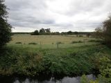
View of Robin Hood's Meadow from Robin Hood's Cave / Jonathan Thacker, 3 Oct. 2018, Creative Commons, via Geograph.

A narrow belt of trees separates Robin Hood's Meadow from the Whitewater / Andrew Hill, 10 Mar. 2013, Creative Commons, via Geograph.
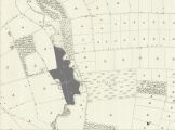
Robin Hood's Meadow indicated in gray / Reproduced with the permission of the National Library of Scotland; Creative Commons; adapted by Henrik Thiil Nielsen.

