
Robin Hood's Larder (Sherwood Forest): Difference between revisions
mNo edit summary |
mNo edit summary |
||
| Line 1: | Line 1: | ||
__NOTOC__{{PnItemTop|Lat=53.200195|Lon=-1.106614|AdmDiv=Nottinghamshire|Vicinity=In Sherwood Forest, ''c.'' 2.5 km WNW of Edwinstowe|Type=Natural feature|Interest=Robin Hood name|Status=Defunct|Demonym=|Riding=|GreaterLondon=|Year=1884|Aka=Shambles; Shambles Oak|Century=|Cluster1=Edwinstowe|Cluster2=Sherwood Forest|Cluster3=|Image=Anonymous 19xxf recto.jpg|Postcards=Yes|ExtraCat1 | __NOTOC__{{PnItemTop|Lat=53.200195|Lon=-1.106614|AdmDiv=Nottinghamshire|Vicinity=In Sherwood Forest, ''c.'' 2.5 km WNW of Edwinstowe|Type=Natural feature|Interest=Robin Hood name|Status=Defunct|Demonym=|Riding=|GreaterLondon=|Year=1884|Aka=Shambles; Shambles Oak|Century=|Cluster1=Edwinstowe|Cluster2=Sherwood Forest|Cluster3=|Image=Anonymous 19xxf recto.jpg|Postcards=Yes|ExtraCat1=Places named Robin Hood's Tree|ExtraCat2=|ExtraCat3=|ExtraCat4=|ExtraCat5=|ExtraLink1=|ExtraLink2=|ExtraLink3=|ExtraLink4=|ExtraLink5=|ExtraLinkName1=|ExtraLinkName2=|ExtraLinkName3=|ExtraLinkName4=|ExtraLinkName5=|GeopointPrefix=|GeopointSuffix=|StatusSuffix=|DatePrefix=|DateSuffix=}} | ||
{{#display_map:{{#var:Coords}}|width=34%}}<div class="pnMapLegend">Approximate location of Robin Hood's Larder. It collapsed in the late 1950's.</div> | {{#display_map:{{#var:Coords}}|width=34%}}<div class="pnMapLegend">Approximate location of Robin Hood's Larder. It collapsed in the late 1950's.</div> | ||
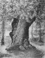
[[File:Anonymous 19xxf recto.jpg|thumb|right|350px|Anonymous. ''Robin Hood's Larder, Sherwood Forest''. [''s.l.'']: [''s.n.''], [''s.d.'']. Photographic postcard (col.) 137 x 87 mm. (private collection.)]] | [[File:Anonymous 19xxf recto.jpg|thumb|right|350px|Anonymous. ''Robin Hood's Larder, Sherwood Forest''. [''s.l.'']: [''s.n.''], [''s.d.'']. Photographic postcard (col.) 137 x 87 mm. (private collection.)]] | ||
<p id="byline">By Henrik Thiil Nielsen, 2016-05-18. Revised by {{#realname:{{REVISIONUSER}}}}, {{REVISIONYEAR}}-{{REVISIONMONTH}}-{{REVISIONDAY2}}.</p> | <p id="byline">By Henrik Thiil Nielsen, 2016-05-18. Revised by {{#realname:{{REVISIONUSER}}}}, {{REVISIONYEAR}}-{{REVISIONMONTH}}-{{REVISIONDAY2}}.</p> | ||
<div class="no-img"> | <div class="no-img"> | ||
Robin Hood's Larder was a large oak tree in an area of Sherwood Foest called Birklands, near the village of Edwinstowe. Robin Hood and his men were said to have hung venison from wooden hooks on this tree, whence also its alternative names of The Shambles and Shambles Oak.<ref>{{:Dobson, Richard Barrie 1976a}}, pp. 302-303, ''s.n.'' 'Robin Hood's Larder' | Robin Hood's Larder was a large oak tree in an area of Sherwood Foest called Birklands, near the village of Edwinstowe. Robin Hood and his men were said to have hung venison from wooden hooks on this tree, whence also its alternative names of The Shambles and Shambles Oak.<ref>{{:Dobson, Richard Barrie 1976a}}, pp. 302-303, ''s.n.'' 'Robin Hood's Larder'. {{:Brentnall, Margaret 1963a}}, see p. 17. [http://maps.nls.uk/view/101602506#zoom=5&lat=1904&lon=3046&layers=BT O.S. 6" Nottinghamshire XVIII.SE (1884; surveyed 1883-1884)].</ref> Robin Hood's Larder stood about 1 km to the west of the [[Major Oak (Sherwood Forest)|Major Oak]], another ancient oak, still standing, that has been connected with the outlaw. So far the earliest source I have found for the place-name is the 6" O.S. map of the area published in 1884 (see Maps section below).<!--=== Allusions === | ||
{{#ask:[[Category:Allusions (Robin Hood's Larder)]]|format=embedded|embedformat=h4|columns=1|limit=1000|sort=Utitle}}--> | {{#ask:[[Category:Allusions (Robin Hood's Larder)]]|format=embedded|embedformat=h4|columns=1|limit=1000|sort=Utitle}}--> | ||
=== Gazetteers === | === Gazetteers === | ||
* {{:Dobson, Richard Barrie 1976a}}, pp. 302-303, ''s.n.'' 'Robin Hood's Larder'. | * {{:Dobson, Richard Barrie 1976a}}, pp. 302-303, ''s.n.'' 'Robin Hood's Larder'. | ||
=== | |||
* | === Discussion === | ||
* {{:Brentnall, Margaret 1963a}}, see p. 17. | |||
=== Maps === | === Maps === | ||
* [http://maps.nls.uk/view/101602506#zoom=5&lat=1904&lon=3046&layers=BT O.S. 6" Nottinghamshire XVIII.SE (1884; surveyed 1883-1884)] | * [http://maps.nls.uk/view/101602506#zoom=5&lat=1904&lon=3046&layers=BT O.S. 6" Nottinghamshire XVIII.SE (1884; surveyed 1883-1884)] | ||
| Line 17: | Line 19: | ||
* [http://maps.nls.uk/view/101602497#zoom=5&lat=1991&lon=2998&layers=BT O.S. 6" Nottinghamshire XVIII.SE (''c.'' 1948; rev. 1938)]; the Major Oak indicated as "The Queen Oak". | * [http://maps.nls.uk/view/101602497#zoom=5&lat=1991&lon=2998&layers=BT O.S. 6" Nottinghamshire XVIII.SE (''c.'' 1948; rev. 1938)]; the Major Oak indicated as "The Queen Oak". | ||
{{PnItemAlsoSee}} | |||
=== Notes === | === Notes === | ||
<references/> | <references/> | ||
Revision as of 11:52, 17 February 2018
By Henrik Thiil Nielsen, 2016-05-18. Revised by Henrik Thiil Nielsen, 2018-02-17.
Robin Hood's Larder was a large oak tree in an area of Sherwood Foest called Birklands, near the village of Edwinstowe. Robin Hood and his men were said to have hung venison from wooden hooks on this tree, whence also its alternative names of The Shambles and Shambles Oak.[1] Robin Hood's Larder stood about 1 km to the west of the Major Oak, another ancient oak, still standing, that has been connected with the outlaw. So far the earliest source I have found for the place-name is the 6" O.S. map of the area published in 1884 (see Maps section below).
Gazetteers
- Dobson, R. B., ed.; Taylor, J., ed. Rymes of Robyn Hood: an Introduction to the English Outlaw (London, 1976), pp. 302-303, s.n. 'Robin Hood's Larder'.
Discussion
Maps
- O.S. 6" Nottinghamshire XVIII.SE (1884; surveyed 1883-1884)
- O.S. 6" Nottinghamshire XVIII.SE (1900; rev. 1897)
- O.S. 6" Nottinghamshire XVIII.SE (1921; rev. 1914); the Major Oak indicated as "The Queen Oak"
- O.S. 6" Nottinghamshire XVIII.SE (c. 1948; rev. 1938); the Major Oak indicated as "The Queen Oak".
Notes
- ↑ Dobson, R. B., ed.; Taylor, J., ed. Rymes of Robyn Hood: an Introduction to the English Outlaw (London, 1976), pp. 302-303, s.n. 'Robin Hood's Larder'. Brentnall, Margaret. 'Robin Hood of Sherwood Forest', [Unknown British travel and tourism magazine] (1963-12), pp. 15-17, 58, see p. 17. O.S. 6" Nottinghamshire XVIII.SE (1884; surveyed 1883-1884).
- Montgomery 19xxa recto.jpg
Montgomery. [Robin Hood's Larder, Sherwood Forest]. [s.l.]: Montgomery, [s.d.]. Picture postcard (col.) 137 x 88 mm. ( Private collection.
- Sherwood Photographic Co. 19xxa recto.jpg
Sherwood Photographic Co. Sherwood Photographic Co. Robin Hood's Larder, Welbeck. [s.l.]: Sherwood Photographic Co., [s.d.] Photographic postcard (monochrome.) 139 x 87 mm / Private collection.
- Anonymous 19xxf recto.jpg
Anonymous. Robin Hood's Larder, Sherwood Forest. [s.l.]: [s.n.], [s.d.]. Photographic postcard (col.) 137 x 87 mm / Private collection.
- R A P Co Ltd, The 19xxa recto.jpg
The R.A.P. Co. Ltd. Robin Hood's Larder, Edwinstowe. London: The R.A.P. Co. Ltd., [s.d.]. Photographic postcard (.b/w.) 141 x 89 mm / Private collection.
Joseph Rodgers, Scenery of Sherwood Forest (1908), p. 192] / Private collection
