
Robin Hood's House (Baildon Green)
| Locality | |
|---|---|
| Coordinate | 53.8451, -1.7933 |
| Adm. div. | West Riding of Yorkshire |
| Vicinity | On Baildon Bank, just above Baildon Green |
| Type | Natural feature |
| Interest | Robin Hood name |
| Status | Defunct? |
| First Record | 1838 |

By Henrik Thiil Nielsen, 2020-06-21. Revised by Henrik Thiil Nielsen, 2022-04-22.
A group of large, probably entirely natural, stones on the slope of Baildon Bank, above Baildon Green, was or is known as 'Robin Hood's House'.
There are quite a few stones or areas of exposed rock in the vicnity, and it is by no means certain that the coordinate listed in the infobox and indicated on the interactive map point to the correct piece(s) of rock. However, the suggested coordinate cannot be off by many tens of meters.
An old Yorkshire local historian writing in the early 20th century was convinced that Robin Hood's House was a cromlech. He believed some, but not all, of the stones had 'been placed in position by man' (see 1913 allusion below). A modern writer on Yorkshire traditions observes, in contrast, that there are no clear indications it was a burial chamber, and 'early antiquarians often misinterpreted natural features for artificial ones'.[1]
According to Amelia Edith Huddleston Barr, the writer of the source of the 1912 allusion below, she was six years old when the event she describes took place. Since she was born on March 29 of 1831 or 1832, this would have been at Midsummer of 1837 or 1838. She does not in fact cite the name 'Robin Hood's House', or any other name for that matter, but instead notes that it was averred that the site 'had been one of Robin Hood's retreats'. This is either a local tradition about to crystallize into the folk-name 'Robin Hood's House' or an etiological myth intended to provide an explanation for an already existing name. Let us be kind to Mrs Barr and assume that she did not pick up the name long after the event – IRHB has no evidence that this was the case – and settle on 1838 as the first date of record. It is in any case not very much earlier than the earliest map evidence, a 6" O.S. map of the area published in 1852, based on a survey carried out 1847–48 (see Maps below). The tithe awards for Shipley and Baildon (both from 1849) do not mention Robin Hood's House,[2]
Allusions
1912 - Baildon, William Paley - Baildon and the Baildons (2)
Robin Hood's House. — This very interesting group of stones lies just above the mill at Baildon Green, some way up the slope of the hill. I think it is unquestionably a cromlech, of the type of "Kit's Coty House" in Kent, "Wayland Smith's Cave" in Berkshire, and others. One side of Robin Hood's House, however, is formed of a huge mass of stone, lying apparently just as it fell from the cliff above; the other stones, some of considerable size, have evidently been placed in position by man. The two views of this curious pre-historic relic give a better idea of it than any description; I am not aware if any excavation has ever been made here.[3]
1913 - Barr, Amelia E - All the Days of My Life
The event of this visit was Baildon Feast, a great public rejoicing on the anniversary of the summer solstice. It had been observed beyond the memory of man, beyond historical notice, beyond even the traditions of the locality. There was no particular reason for its observance that I could ever learn; it was just Baildon Feast, and that was all anybody knew about it.
I was awakened very early on the first day of the feast by the bands "playing the sun up," and before we had finished breakfast the procession was forming. Now Baildon Green is flat and grassy as a meadow, and when I was six years old it had a pond in the center, while from the northwest there rose high hills. Only a narrow winding path led to the top of these hills, and about half way up, there was a cave which tradition averred had been one of Robin Hood's retreats — a very probable circumstance, as this whole country-side was doubtless pretty well covered with oak forests.
A numerous deputation from the village of Baildon, situated on the top of the hill, joined the procession which started from Baildon Green at an early hour. The sun was shining brightly, and I had on a clean white frock, pretty white sandals, a new blue sash, and a gypsy hat trimmed with blue ribbons. When the music approached it put a spirit into my feet and my heart [p. 17:] kept time to the exciting melody. I had never walked to music before, and it was an enchanting experience.
The procession appeared to my childish apprehension a very great one. I think now it may have consisted of five hundred people, perhaps less, but the great point of interest was two fine young heifers garlanded with flowers, and ornamented with streaming ribbons of every color. Up the winding path they went, the cattle lowing, the bands playing, the people singing and shouting up to the high places on which the village of Baildon stood. There at a particular spot, hallowed by tradition, the cattle garlanded for sacrifice were slain. I do not know whether any particular method or forms were used. I was not permitted to see the ceremony attending their death, and I confess I was much disappointed.[4]
Gazetteers
- Not included in Dobson, R. B., ed.; Taylor, J., ed. Rymes of Robyn Hood: an Introduction to the English Outlaw (London, 1976), pp. 293-311.
- The Northern Antiquarian: Sacred Nature: Rocks, Hills, Lakes.
Maps
- 25" O.S. map Yorkshire CCI.7 (c. 1893; surveyed c. 1890–81). No copy in NLS
- 25" O.S. map Yorkshire CCI.7 (1908; rev. 1906) (georeferenced)
- 25" O.S. map Yorkshire CCI.7 (1908; rev. 1906)
- 25" O.S. map Yorkshire CCI.7 (1922; rev. 1913)
- 25" O.S. map Yorkshire CCI.7 (1935; rev. 1934)
- 6" O.S. map Yorkshire 201 (1852; surveyed 1847–48)
- 6" O.S. map Yorkshire CCI.NE (1894; surveyed 1889–91)
- 6" O.S. map Yorkshire CCI.NE (1909; rev. 1906) (georeferenced)
- 6" O.S. map Yorkshire CCI.NE (1909; rev. 1906)
- 6" O.S. map Yorkshire CCI.NE (1934; rev. 1934).
Discussion
Background
- 1845 tithe award for Baildon, online at the Genealogist, Piece 43, sub-piece 027, Image 413, item 587; Image 426, item 550 (£)
- 1849 tithe award for Shipley, online at the Genealogist, Piece 43, sub-piece 352, Images 423-54 (£)
Also see
Notes
- ↑ Kai Roberts: Old Elmet Dreaming: Tag Archives: Robin Hood: The Folklore of Shipley Glen & Baildon Moor.
- ↑ MS tithe awards for Shipley and Baildon, online at the Genealogist, Piece 43, sub-piece 352, Images 423-54; and piece 43, sub-piece 027, Image 413, item 587; Image 426, item 550 (£).]
- ↑ Baildon, W. Paley; Baildon, Francis J. Baildon and the Baildons: a History of a Yorkshire Manor and Family ([s.l.]; Bradford and London, [1912-26]), vol. I, p. 14.
- ↑ Barr, Amelia E. All the Days of My Life: An Autobiography – The Red Leaves of a Human Heart (New York and London, 1913), pp. 16-17.
Image gallery
Click any image to display it in the lightbox, where you can navigate between images by clicking in the right or left side of the current image.
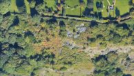
Robin Hood's House would be a little to the right and below centre of this photo / Google Earth Street View.
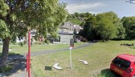
View from Green Road. Robin Hood's House is part of the rocks above the buildings or perhaps situated a little to the right (east) of them / Google Earth Street View.
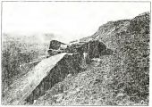
'Robin Hood's House, East View'. Can this very poor scan help identify the rock? / Baildon, W. Paley; Baildon, Francis J. Baildon and the Baildons: a History of a Yorkshire Manor and Family ([s.l.]; Bradford and London, [1912-26]), plate after p. 114.
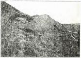
'Robin Hood's House, West View'. Can this very poor scan help identify the rock? / Baildon, W. Paley; Baildon, Francis J. Baildon and the Baildons: a History of a Yorkshire Manor and Family ([s.l.]; Bradford and London, [1912-26]), plate after p. 114.


