Robin Hood's Hole (Goldsborough)
From International Robin Hood Bibliography
Revision as of 03:04, 17 July 2018 by Henryfunk (talk | contribs) (Text replacement - "{{#ask:[[Category:Records ({{#ifeq:{{#pos:{{PAGENAME}}|(|}}||{{PAGENAME}}|{{#sub:{{PAGENAME}}|0| {{#expr:{{#pos:{{PAGENAME}}|(|}}-1}} }},{{#sub:{{PAGENAME}}|{{#expr:{{#pos:{{PAGENAME}}|(|}}-1}}|1}}{{#sub:{{PAGENAME}}|{{#expr:{{#pos:...)
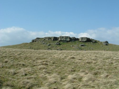
Robin Hood's Hole on Goldsborough.

The feature named Robin Hood's Hole was (is?) found on Goldsborough. Here the hill is viewed from the south / James@hopgrove, Wikimedia Commons, public domain.
By Henrik Thiil Nielsen, 2016-05-22. Revised by Henrik Thiil Nielsen, 2018-07-17.
Some feature – perhaps a small pond, cave or depression – on the flat peak of the 388 m high hill named Goldsborough in Cotherstone, was known as Robin Hood's Hole in the 19th century. The name is indicated on three 6" O.S. maps produced in the years 1854 to 1919.[1] The parish of Cotherstone, in the Pennines, then belonged to the North Riding of Yorkshire but now is in County Durham.[2] Goldsborough is situated in a large area of boggy moorland. Geograph.co.uk contributor Mick Garratt noted in 2015 that "I went looking for Robin Hood's Hole expecting a cave or pothole but couldn't find anything."[3]Template:PnItemQry
Gazetteers
- Not included in Dobson, R. B., ed.; Taylor, J., ed. Rymes of Robyn Hood: an Introduction to the English Outlaw (London, 1976), pp. 293-311.
Maps
- 6" O.S. map Yorkshire 11 (incl. Bowes; Cotherstone; Lartington) (1857, surveyed 1854)
- 6" O.S. map Yorkshire XI.NE (incl. Bowes; Cotherstone; Lartington) (1895, surveyed 1891)
- 6" O.S. map Yorkshire XI.NE (incl. Bowes; Cotherstone; Lartington) (1919, surveyed 1912.)
Background
Brief mention
Notes
- ↑ See 6" O.S. map Yorkshire 11 (incl. Bowes; Cotherstone; Lartington) (1857, surveyed 1854); 6" O.S. map Yorkshire XI.NE (incl. Bowes; Cotherstone; Lartington) (1895, surveyed 1891), and 6" O.S. map Yorkshire XI.NE (incl. Bowes; Cotherstone; Lartington) (1919, surveyed 1912.)
- ↑ Wikipedia: Goldsborough (hill).
- ↑ geograph.co.uk – NY9517: Goldsborough.
