
Robin Hood's Coppice (Arborfield): Difference between revisions
From International Robin Hood Bibliography
(Created page with "__NOTOC__{{PnItemTop|Lat=51.3837|Lon=-0.9110|AdmDiv=Berkshire|Vicinity=''c.'' 110 m W of Eversley Road; immediately SW of Poperinghe Way|Type=Natural feature|Interest=Robin Ho...") |
mNo edit summary |
||
| Line 1: | Line 1: | ||
__NOTOC__{{PnItemTop|Lat=51. | __NOTOC__{{PnItemTop|Lat=51.383834|Lon=-0.910912|AdmDiv=Berkshire|Vicinity=''c.'' 110 m W of Eversley Road; immediately SW of Poperinghe Way|Type=Natural feature|Interest=Robin Hood name|Status=Extant|Demonym=English|Riding=|GreaterLondon=|Year=1839|Aka=Robin Hood Coppice; Robinhood Copse|Century=|Cluster1=Arborfield|Cluster2=|Cluster3=|Image=robin-hoods-coppice-arborfield-google-earth-street-view.jpg|Postcards=|ExtraCat1=Places named Robin Hood's Wood|ExtraCat2=|ExtraCat3=|ExtraCat4=|ExtraCat5=|ExtraLink1=|ExtraLink2=|ExtraLink3=|ExtraLink4=|ExtraLink5=|ExtraLinkName1=|ExtraLinkName2=|ExtraLinkName3=|ExtraLinkName4=|ExtraLinkName5=|GeopointPrefix=|GeopointSuffix=|StatusSuffix=|DatePrefix=|DateSuffix=}} | ||
{{#display_map:{{#var:Coords}}~ | {{#display_map:{{#var:Coords}}~Robin Hood's Coppice|width=34%}}<div class="pnMapLegend">Robin Hood's Coppice, Arborfield</div> | ||
[[File:{{#var:Pnimage}}|thumb|right|500px|Robin Hood's Coppice, Arborfield / Google Earth Street View.]] | [[File:{{#var:Pnimage}}|thumb|right|500px|Robin Hood's Coppice, Arborfield / Google Earth Street View.]] | ||
<p id="byline">By Henrik Thiil Nielsen, 2018-09-20. Revised by {{#realname:{{REVISIONUSER}}}}, {{REVISIONYEAR}}-{{REVISIONMONTH}}-{{REVISIONDAY2}}.</p><div class="no-img"> | <p id="byline">By Henrik Thiil Nielsen, 2018-09-20. Revised by {{#realname:{{REVISIONUSER}}}}, {{REVISIONYEAR}}-{{REVISIONMONTH}}-{{REVISIONDAY2}}.</p><div class="no-img"> | ||
| Line 26: | Line 26: | ||
<references/>--> | <references/>--> | ||
</div> | </div> | ||
{{ImgGalleryIntro}} | {{ImgGalleryIntro}} | ||
<gallery widths="195px"> | <gallery widths="195px"> | ||
File:robin-hoods-coppice-arborfield-google-earth-street-view.jpg|Robinhood Copse, as it is now known, is the wooded area behind the house farthest from the camera / Google Earth Street View. | |||
</gallery | </gallery> | ||
{{PnItemNav}} | {{PnItemNav}} | ||
Revision as of 21:40, 20 September 2018
Robin Hood's Coppice, Arborfield
[[File:|thumb|right|500px|Robin Hood's Coppice, Arborfield / Google Earth Street View.]]
By Henrik Thiil Nielsen, 2018-09-20. Revised by Henrik Thiil Nielsen, 2018-09-20.
Gazetteers
- Not included in Dobson, R. B., ed.; Taylor, J., ed. Rymes of Robyn Hood: an Introduction to the English Outlaw (London, 1976), pp. 315-19.
Maps
- 25" O.S. map Berkshire XLVI.5 (c. 1875; surveyed 1871). (No Copy in NLS)
- 25" O.S. map Berkshire XLVI.5 (c. 1899; rev. c. 1898). (No Copy in NLS)
- 25" O.S. map Berkshire XLVI.5 (1911; rev. 1910)
- 25" O.S. map Berkshire XLVI.5 (1911; rev. 1910) (georeferenced)
- 25" O.S. map Berkshire XLVI.5 (1933; rev. 1932)
- 6" O.S. map Berkshire XLVI (1876; surveyed 1871-72)
- 6" O.S. map Berkshire XLVI.NW (1900; rev. 1899) (georeferenced)
- 6" O.S. map Berkshire XLVI.NW (1900; rev. 1899)
- 6" O.S. map Berkshire XLVI.NW (1912; rev. 1910)
- 6" O.S. map Berkshire XLVI.NW (c. 1934; rev. 1932)
- 6" O.S. map Berkshire XLVI.NW (c. 1944; rev. 1938).
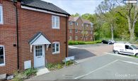
Robinhood Copse, as it is now known, is the wooded area behind the house farthest from the camera / Google Earth Street View.
