
Robin Hood's Coppice (Arborfield): Difference between revisions
m (Text replacement - "PnItemTop" to "PlaceNamesItemTop") |
m (Text replacement - "No Copy in NLS" to "No copy in NLS") |
||
| (7 intermediate revisions by the same user not shown) | |||
| Line 6: | Line 6: | ||
The locality is included, as "Robin Hood's Coppice", on the tithe map for Arborfield (1839).<ref>1839 tithe map for Arborfield parish, online at the Genealogist.co.uk, piece 02, sub-piece 007, sub-image 001 ( | The locality is included, as "Robin Hood's Coppice", on the tithe map for Arborfield (1839).<ref>1839 tithe map for Arborfield parish, online at the Genealogist.co.uk, piece 02, sub-piece 007, sub-image 001 (£). {{:Gelling, Margaret 1973a}}, pt. I, p. 124 (and see p. 123 for parish),</ref> while in the tithe award (1841) it is listed as "Robin Wood Coppice", with Henry Simonds, Esq., as owner/occupier, state of cultivation as "Underwood", and with an area of 2 acres, 3 roods and 14 perches ({{AcresRoodsPerchesToM2|2|3|14}} m<sup>2</sup>).<ref>1841 tithe award for Arborfield parish, online at the Genealogist.co.uk, piece 02, sub-piece 007, image 012, Plot No. 286 (£).</ref> The area is labelled "Robinhood Copse" on O.S. maps published 1876 to ''c.'' 1944 (see maps below). An adjacent area was formerly known as [[Robin Wood Ground (Arborfield)|Robin Wood Ground]].{{PlaceNamesItemAllusionsAndRecords}} | ||
== Gazetteers == | == Gazetteers == | ||
* Not included in {{:Dobson, Richard Barrie 1976a}}, pp. 293-11. | * Not included in {{:Dobson, Richard Barrie 1976a}}, pp. 293-11. | ||
== MS sources == | == MS sources == | ||
* 1839 tithe map for Arborfield parish, online at the [https://www.thegenealogist.co.uk Genealogist.co.uk], piece 02, sub-piece 007, sub-image 001 ( | * 1839 tithe map for Arborfield parish, online at the [https://www.thegenealogist.co.uk Genealogist.co.uk], piece 02, sub-piece 007, sub-image 001 (£) | ||
* 1841 tithe award for Arborfield parish, online at the [https://www.thegenealogist.co.uk Genealogist.co.uk], piece 02, sub-piece 007, image 012, Plot No. 286 ( | * 1841 tithe award for Arborfield parish, online at the [https://www.thegenealogist.co.uk Genealogist.co.uk], piece 02, sub-piece 007, image 012, Plot No. 286 (£). | ||
== Printed and web sources == | == Printed and web sources == | ||
* [https://foursquare.com/v/robinhood-copse/4ee354297ee5334d941576fe Foursquare: Robinhood Copse] | * [https://foursquare.com/v/robinhood-copse/4ee354297ee5334d941576fe Foursquare: Robinhood Copse] | ||
* {{:Gelling, Margaret 1973a}}, pt. I, p. 124 (and see p. 123 for parish). | * {{:Gelling, Margaret 1973a}}, pt. I, p. 124 (and see p. 123 for parish). | ||
== Maps == | == Maps == | ||
* 25" O.S. map ''Berkshire'' XLVI.5 (''c.'' 1875; surveyed 1871). (No | * 25" O.S. map ''Berkshire'' XLVI.5 (''c.'' 1875; surveyed 1871). (No copy in NLS) | ||
* 25" O.S. map ''Berkshire'' XLVI.5 (''c.'' 1899; rev. ''c.'' 1898). (No | * 25" O.S. map ''Berkshire'' XLVI.5 (''c.'' 1899; rev. ''c.'' 1898). (No copy in NLS) | ||
* [https://maps.nls.uk/view/104198731#zoom=4&lat=8051&lon=5175&layers=BT 25" O.S. map ''Berkshire'' XLVI.5 (1911; rev. 1910)] | * [https://maps.nls.uk/view/104198731#zoom=4&lat=8051&lon=5175&layers=BT 25" O.S. map ''Berkshire'' XLVI.5 (1911; rev. 1910)] | ||
* [https://maps.nls.uk/geo/explore/#zoom=17&lat=51.3839&lon=-0.9112&layers=168&b=5 25" O.S. map ''Berkshire'' XLVI.5 (1911; rev. 1910)] (georeferenced) | * [https://maps.nls.uk/geo/explore/#zoom=17&lat=51.3839&lon=-0.9112&layers=168&b=5 25" O.S. map ''Berkshire'' XLVI.5 (1911; rev. 1910)] (georeferenced) | ||
| Line 30: | Line 30: | ||
== Background == | == Background == | ||
== Brief mention ==--> | == Brief mention ==--> | ||
{{ | {{PlaceNamesItemAlsoSee}} | ||
== Notes == | == Notes == | ||
<references/> | <references/> | ||
| Line 36: | Line 36: | ||
<div id="gallery"> | <div id="gallery"> | ||
{{ | {{ImageGalleryIntroduction}} | ||
<gallery widths="195px"> | <gallery widths="195px"> | ||
File:robin-hoods-coppice-arborfield-richard-peat.jpg|Foot- and bicyclepath in Robin Hood's Coppice, now Robinhood Copse, Arborfield / [https://foursquare.com/v/robinhood-copse/4ee354297ee5334d941576fe Richard Peat, 4 Oct. 2014, via Foursquare.] | File:robin-hoods-coppice-arborfield-richard-peat.jpg|Foot- and bicyclepath in Robin Hood's Coppice, now Robinhood Copse, Arborfield / [https://foursquare.com/v/robinhood-copse/4ee354297ee5334d941576fe Richard Peat, 4 Oct. 2014, via Foursquare.] | ||
| Line 43: | Line 43: | ||
</div> | </div> | ||
{{ | {{PlaceNamesItemNavigation}} | ||
Revision as of 01:04, 13 February 2021
| Locality | |
|---|---|
| Coordinate | 51.383834, -0.910912 |
| Adm. div. | Berkshire |
| Vicinity | c. 110 m W of Eversley Road (A327); immediately SW of Poperinghe Way |
| Type | Natural feature |
| Interest | Robin Hood name |
| Status | Extant |
| First Record | 1839 |
| A.k.a. | Robin Hood Coppice; Robinhood Copse |

By Henrik Thiil Nielsen, 2018-09-20. Revised by Henrik Thiil Nielsen, 2021-02-13.
Robinhood Copse, formerly known as Robin Hood's Coppice, is a small wooded area in Arborfield, c. 110 m west of Eversley Road (A327) and immediately southwest of a residential street named Poperinghe Way. The name is first recorded in 1839.
The locality is included, as "Robin Hood's Coppice", on the tithe map for Arborfield (1839).[1] while in the tithe award (1841) it is listed as "Robin Wood Coppice", with Henry Simonds, Esq., as owner/occupier, state of cultivation as "Underwood", and with an area of 2 acres, 3 roods and 14 perches (11482.96 m2).[2] The area is labelled "Robinhood Copse" on O.S. maps published 1876 to c. 1944 (see maps below). An adjacent area was formerly known as Robin Wood Ground.
Gazetteers
- Not included in Dobson, R. B., ed.; Taylor, J., ed. Rymes of Robyn Hood: an Introduction to the English Outlaw (London, 1976), pp. 293-11.
MS sources
- 1839 tithe map for Arborfield parish, online at the Genealogist.co.uk, piece 02, sub-piece 007, sub-image 001 (£)
- 1841 tithe award for Arborfield parish, online at the Genealogist.co.uk, piece 02, sub-piece 007, image 012, Plot No. 286 (£).
Printed and web sources
- Foursquare: Robinhood Copse
- Gelling, Margaret. The Place-Names of Berkshire (English Place-Name Society, vols. XLIX-LI) (Cambridge, 1973; [s.l.], 1974-76), pt. I, p. 124 (and see p. 123 for parish).
Maps
- 25" O.S. map Berkshire XLVI.5 (c. 1875; surveyed 1871). (No copy in NLS)
- 25" O.S. map Berkshire XLVI.5 (c. 1899; rev. c. 1898). (No copy in NLS)
- 25" O.S. map Berkshire XLVI.5 (1911; rev. 1910)
- 25" O.S. map Berkshire XLVI.5 (1911; rev. 1910) (georeferenced)
- 25" O.S. map Berkshire XLVI.5 (1933; rev. 1932)
- 6" O.S. map Berkshire XLVI (1876; surveyed 1871-72)
- 6" O.S. map Berkshire XLVI.NW (1900; rev. 1899) (georeferenced)
- 6" O.S. map Berkshire XLVI.NW (1900; rev. 1899)
- 6" O.S. map Berkshire XLVI.NW (1912; rev. 1910)
- 6" O.S. map Berkshire XLVI.NW (c. 1934; rev. 1932)
- 6" O.S. map Berkshire XLVI.NW (c. 1944; rev. 1938).
Also see
Notes
- ↑ 1839 tithe map for Arborfield parish, online at the Genealogist.co.uk, piece 02, sub-piece 007, sub-image 001 (£). Gelling, Margaret. The Place-Names of Berkshire (English Place-Name Society, vols. XLIX-LI) (Cambridge, 1973; [s.l.], 1974-76), pt. I, p. 124 (and see p. 123 for parish),
- ↑ 1841 tithe award for Arborfield parish, online at the Genealogist.co.uk, piece 02, sub-piece 007, image 012, Plot No. 286 (£).
Image gallery
Click any image to display it in the lightbox, where you can navigate between images by clicking in the right or left side of the current image.

Foot- and bicyclepath in Robin Hood's Coppice, now Robinhood Copse, Arborfield / Richard Peat, 4 Oct. 2014, via Foursquare.
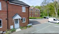
Robinhood Copse, as it is now known, is the wooded area behind the house farthest from the camera / Google Earth Street View.
