
Robin Hood's Coppice (Arborfield): Difference between revisions
From International Robin Hood Bibliography
mNo edit summary |
mNo edit summary |
||
| Line 29: | Line 29: | ||
{{ImgGalleryIntro}} | {{ImgGalleryIntro}} | ||
<gallery widths="195px"> | <gallery widths="195px"> | ||
File:robin-hoods-coppice-arborfield-richard-peat.jpg|Foot- and bicyclepath in Robin Hood's Coppice, now Robinhood Copse, Arborfield / [https://foursquare.com/v/robinhood-copse/4ee354297ee5334d941576fe Richard Peat, 4 Oct. 2014, via Foursquare.] | |||
File:robin-hoods-coppice-arborfield-google-earth-street-view.jpg|Robinhood Copse, as it is now known, is the wooded area behind the house farthest from the camera / Google Earth Street View. | File:robin-hoods-coppice-arborfield-google-earth-street-view.jpg|Robinhood Copse, as it is now known, is the wooded area behind the house farthest from the camera / Google Earth Street View. | ||
</gallery> | </gallery> | ||
Revision as of 21:53, 20 September 2018
Robin Hood's Coppice, Arborfield
[[File:|thumb|right|380px|Foot- and bicyclepath in Robin Hood's Coppice, now Robinhood Copse, Arborfield / Richard Peat, 4 Oct. 2014, via Foursquare.]]
By Henrik Thiil Nielsen, 2018-09-20. Revised by Henrik Thiil Nielsen, 2018-09-20.
Gazetteers
- Not included in Dobson, R. B., ed.; Taylor, J., ed. Rymes of Robyn Hood: an Introduction to the English Outlaw (London, 1976), pp. 315-19.
Maps
- 25" O.S. map Berkshire XLVI.5 (c. 1875; surveyed 1871). (No Copy in NLS)
- 25" O.S. map Berkshire XLVI.5 (c. 1899; rev. c. 1898). (No Copy in NLS)
- 25" O.S. map Berkshire XLVI.5 (1911; rev. 1910)
- 25" O.S. map Berkshire XLVI.5 (1911; rev. 1910) (georeferenced)
- 25" O.S. map Berkshire XLVI.5 (1933; rev. 1932)
- 6" O.S. map Berkshire XLVI (1876; surveyed 1871-72)
- 6" O.S. map Berkshire XLVI.NW (1900; rev. 1899) (georeferenced)
- 6" O.S. map Berkshire XLVI.NW (1900; rev. 1899)
- 6" O.S. map Berkshire XLVI.NW (1912; rev. 1910)
- 6" O.S. map Berkshire XLVI.NW (c. 1934; rev. 1932)
- 6" O.S. map Berkshire XLVI.NW (c. 1944; rev. 1938).

Foot- and bicyclepath in Robin Hood's Coppice, now Robinhood Copse, Arborfield / Richard Peat, 4 Oct. 2014, via Foursquare.
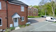
Robinhood Copse, as it is now known, is the wooded area behind the house farthest from the camera / Google Earth Street View.

