
Robin Hood's Butt (Elford): Difference between revisions
m (→Sources) |
mNo edit summary |
||
| Line 4: | Line 4: | ||
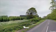
[[File:{{#var:Pnimage}}|thumb|right|500px|Elford Low, on which the large solitary tree stands, was known as 'Robin Hood's Butt' in the 19th century and earlier / Google Earth Street View]] | [[File:{{#var:Pnimage}}|thumb|right|500px|Elford Low, on which the large solitary tree stands, was known as 'Robin Hood's Butt' in the 19th century and earlier / Google Earth Street View]] | ||
<div class="no-img"><p id="byline">By Henrik Thiil Nielsen, 2020-10-28. Revised by {{#realname:{{REVISIONUSER}}}}, {{REVISIONYEAR}}-{{REVISIONMONTH}}-{{REVISIONDAY2}}.</p> | <div class="no-img"><p id="byline">By Henrik Thiil Nielsen, 2020-10-28. Revised by {{#realname:{{REVISIONUSER}}}}, {{REVISIONYEAR}}-{{REVISIONMONTH}}-{{REVISIONDAY2}}.</p> | ||
The mound now generally known as 'Elford Low', situated on the east side of Tamworth Road (A513), c. 800 m south-southeast of the village of Elford, had the alternative name of 'Robin Hood's Butt' according to local historians writing in the late 18th to mid-19th century. Another, now unidentifiable, mound situated three or four kilometres southwest of it was known under the same name. It was said, during the first half of the 19th century, that Robin Hood used to shoot arrows from one to the other. | |||
{{PnItemQry}} | {{PnItemQry}} | ||
== Gazetteers == | == Gazetteers == | ||
Revision as of 08:33, 29 October 2020
[[File:|thumb|right|500px|Elford Low, on which the large solitary tree stands, was known as 'Robin Hood's Butt' in the 19th century and earlier / Google Earth Street View]]
By Henrik Thiil Nielsen, 2020-10-28. Revised by Henrik Thiil Nielsen, 2020-10-29.
The mound now generally known as 'Elford Low', situated on the east side of Tamworth Road (A513), c. 800 m south-southeast of the village of Elford, had the alternative name of 'Robin Hood's Butt' according to local historians writing in the late 18th to mid-19th century. Another, now unidentifiable, mound situated three or four kilometres southwest of it was known under the same name. It was said, during the first half of the 19th century, that Robin Hood used to shoot arrows from one to the other. Template:PnItemQry
Gazetteers
- Not included in Dobson, R. B., ed.; Taylor, J., ed. Rymes of Robyn Hood: an Introduction to the English Outlaw (London, 1976), pp. 293-311.
Sources
- PastScape: Robin Hoods Butt
- Shaw, Stebbing; et al. The History and Antiquities of Staffordshire, compiled from the Manuscripts of Huntbach, Loxdale, Bishop Lyttelton, and Other Collections of Dr. Wilkes, T. Feilde, &c. &c., Including Erdeswick's Survey of the County, and the Approved Parts of Dr. Plot's Natural History (London, 1798-1801), vol. I, p. 432. Not seen but cf. PastScape, just cited.
Maps
- 25" O.S. map Staffordshire LIII.14 (c. 1883; surveyed c. 1882). No Copy in NLS
- 25" O.S. map Staffordshire LIII.14 (1901; rev. 1900) (georeferenced)
- 25" O.S. map Staffordshire LIII.14 (1901; rev. 1900)
- 25" O.S. map Staffordshire LIII.14 (1923; rev. 1921)
- 6" O.S. map Staffordshire LIII.SW (1885; surveyed 1881–82)
- 6" O.S. map Staffordshire LIII.SW (1902; rev. 1900) (georeferenced)
- 6" O.S. map Staffordshire LIII.SW (1902; rev. 1900)
- 6" O.S. map Staffordshire LIII.SW (1925; rev. 1921).
Discussion
- Wikipedia: Elford
- Tamworth Time Hikes: Robin Hood's Butt
- Tamworth Time Hikes: Robin Hood's Butt and beyond.
Notes
Elford Low was known as 'Robin Hood's Butt' in the 19th century and earlier / Google Earth Street View
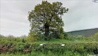
Elford Low or Robin Hood's Butt / Google Earth Street View

