
Robin Hood's Butt (Elford): Difference between revisions
From International Robin Hood Bibliography
mNo edit summary |
mNo edit summary |
||
| Line 1: | Line 1: | ||
__NOTOC__{{PnItemTop|Lat=52.680611|Lon=-1.714604|AdmDiv=Staffordshire|Vicinity=''c.'' 800 m SSE of village of Elford; E side of Tamworth Road (A513)|Type=Prehistoric site|Interest=Robin Hood name| | __NOTOC__{{PnItemTop|Lat=52.680611|Lon=-1.714604|AdmDiv=Staffordshire|Vicinity=''c.'' 800 m SSE of village of Elford; E side of Tamworth Road (A513)|Type=Prehistoric site|Interest=Robin Hood name| | ||
Status=Defunct|Demonym=|Riding=|GreaterLondon=|Year=1798|Aka=Robin Hood's Shooting Butts; Elford Low|Century=|Cluster1=|Cluster2=|Cluster3=|Image=robin-hoods-butt-elford-google-earth-street-view-1.jpg|Postcards=|ExtraCat1=Places named Robin Hood's Butts|ExtraCat2=Places connected by bowshot|ExtraCat3=|ExtraCat4=|ExtraCat5=|ExtraLink1=Robin Hood's Butt (Wigginton)|ExtraLink2=Robin Hood's Butts (Combridge)|ExtraLink3=|ExtraLink4=|ExtraLink5=|ExtraLinkName1=|ExtraLinkName2=|ExtraLinkName3=|ExtraLinkName4=|ExtraLinkName5=|GeopointPrefix=|GeopointSuffix=|VicinitySuffix=|StatusSuffix=?|DatePrefix=|DateSuffix=}} | Status=Defunct|Demonym=|Riding=|GreaterLondon=|Year=1798|Aka=Robin Hood's Shooting Butts; Elford Low|Century=|Cluster1=|Cluster2=|Cluster3=|Image=robin-hoods-butt-elford-google-earth-street-view-1.jpg|Postcards=|ExtraCat1=Places named Robin Hood's Butts|ExtraCat2=Places connected by bowshot|ExtraCat3=|ExtraCat4=|ExtraCat5=|ExtraLink1=Robin Hood's Butt (Wigginton)|ExtraLink2=Robin Hood's Butts (Combridge)|ExtraLink3=|ExtraLink4=|ExtraLink5=|ExtraLinkName1=|ExtraLinkName2=|ExtraLinkName3=|ExtraLinkName4=|ExtraLinkName5=|GeopointPrefix=|GeopointSuffix=|VicinitySuffix=|StatusSuffix=?|DatePrefix=|DateSuffix=}} | ||
{{#display_map:{{#var:Coords}}~{{#replace:{{PAGENAME}}|'|'}};52.6518,-1.7135~Robin Hood's Butt (Wigginton)|width=34%}}<div class="pnMapLegend"> | {{#display_map:{{#var:Coords}}~{{#replace:{{PAGENAME}}|'|'}};52.6518,-1.7135~Robin Hood's Butt (Wigginton)|width=34%}}<div class="pnMapLegend">North to south: Robin Hood's Butt, Elford; general area where Robin Hood's Butt, Wigginton, is located.</div> | ||
[[File:{{#var:Pnimage}}|thumb|right|500px|Elford Low, on which the large solitary tree stands, was known as 'Robin Hood's Butt' in the 19th century and earlier / Google Earth Street View]] | [[File:{{#var:Pnimage}}|thumb|right|500px|Elford Low, on which the large solitary tree stands, was known as 'Robin Hood's Butt' in the 19th century and earlier / Google Earth Street View]] | ||
<div class="no-img"><p id="byline">By Henrik Thiil Nielsen, 2020-10-28. Revised by {{#realname:{{REVISIONUSER}}}}, {{REVISIONYEAR}}-{{REVISIONMONTH}}-{{REVISIONDAY2}}.</p> | <div class="no-img"><p id="byline">By Henrik Thiil Nielsen, 2020-10-28. Revised by {{#realname:{{REVISIONUSER}}}}, {{REVISIONYEAR}}-{{REVISIONMONTH}}-{{REVISIONDAY2}}.</p> | ||
Revision as of 18:13, 28 October 2020
North to south: Robin Hood's Butt, Elford; general area where Robin Hood's Butt, Wigginton, is located.
[[File:|thumb|right|500px|Elford Low, on which the large solitary tree stands, was known as 'Robin Hood's Butt' in the 19th century and earlier / Google Earth Street View]]
By Henrik Thiil Nielsen, 2020-10-28. Revised by Henrik Thiil Nielsen, 2020-10-28.
Gazetteers
- Not included in Dobson, R. B., ed.; Taylor, J., ed. Rymes of Robyn Hood: an Introduction to the English Outlaw (London, 1976), pp. 293-311.
Sources
Maps
- 25" O.S. map Staffordshire LIII.14 (c. 1883; surveyed c. 1882). No Copy in NLS
- 25" O.S. map Staffordshire LIII.14 (1901; rev. 1900) (georeferenced)
- 25" O.S. map Staffordshire LIII.14 (1901; rev. 1900)
- 25" O.S. map Staffordshire LIII.14 (1923; rev. 1921)
- 6" O.S. map Staffordshire LIII.SW (1885; surveyed 1881–82)
- 6" O.S. map Staffordshire LIII.SW (1902; rev. 1900) (georeferenced)
- 6" O.S. map Staffordshire LIII.SW (1902; rev. 1900)
- 6" O.S. map Staffordshire LIII.SW (1925; rev. 1921).
Discussion
- Wikipedia: Elford
- Tamworth Time Hikes: Robin Hood's Butt
- Tamworth Time Hikes: Robin Hood's Butt and beyond.
Notes
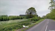
Elford Low was known as 'Robin Hood's Butt' in the 19th century and earlier / Google Earth Street View
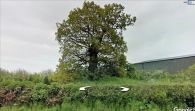
Elford Low or Robin Hood's Butt / Google Earth Street View

