
Robin Hood's Butt (Elford): Difference between revisions
From International Robin Hood Bibliography
mNo edit summary |
mNo edit summary |
||
| Line 8: | Line 8: | ||
== Gazetteers == | == Gazetteers == | ||
* Not included in {{:Dobson, Richard Barrie 1976a}}, pp. 293-311. | * Not included in {{:Dobson, Richard Barrie 1976a}}, pp. 293-311. | ||
== Sources == | |||
* | * [https://www.pastscape.org.uk/hob.aspx?hob_id=309841&sort=2&type=&rational=a&class1=None&period=None&county=100249&district=None&parish=None&place=Wigginton&recordsperpage=10&source=text&rtype=&rnumber=&p=1&move=n&nor=16&recfc=0 PastScape: Robin Hoods Butt.] | ||
== Maps == | == Maps == | ||
* 25" O.S. map ''Staffordshire'' LIII.14 (''c.'' 1883; surveyed ''c.'' 1882). No Copy in NLS | * 25" O.S. map ''Staffordshire'' LIII.14 (''c.'' 1883; surveyed ''c.'' 1882). No Copy in NLS | ||
| Line 19: | Line 19: | ||
* [https://maps.nls.uk/view/101597033#zoom=7&lat=2135&lon=6562&layers=BT 6" O.S. map ''Staffordshire'' LIII.SW (1902; rev. 1900)] | * [https://maps.nls.uk/view/101597033#zoom=7&lat=2135&lon=6562&layers=BT 6" O.S. map ''Staffordshire'' LIII.SW (1902; rev. 1900)] | ||
* [https://maps.nls.uk/view/101597030#zoom=7&lat=2351&lon=6501&layers=BT 6" O.S. map ''Staffordshire'' LIII.SW (1925; rev. 1921).] | * [https://maps.nls.uk/view/101597030#zoom=7&lat=2351&lon=6501&layers=BT 6" O.S. map ''Staffordshire'' LIII.SW (1925; rev. 1921).] | ||
== Discussion == | == Discussion == | ||
* [https://en.wikipedia.org/wiki/Elford Wikipedia: Elford] | * [https://en.wikipedia.org/wiki/Elford Wikipedia: Elford] | ||
Revision as of 17:33, 28 October 2020
Robin Hood's Butt (Elford).
[[File:|thumb|right|500px|Elford Low, on which the large solitary tree stands, was known as 'Robin Hood's Butt' in the 19th century and earlier / Google Earth Street View]]
By Henrik Thiil Nielsen, 2020-10-28. Revised by Henrik Thiil Nielsen, 2020-10-28.
Gazetteers
- Not included in Dobson, R. B., ed.; Taylor, J., ed. Rymes of Robyn Hood: an Introduction to the English Outlaw (London, 1976), pp. 293-311.
Sources
Maps
- 25" O.S. map Staffordshire LIII.14 (c. 1883; surveyed c. 1882). No Copy in NLS
- 25" O.S. map Staffordshire LIII.14 (1901; rev. 1900) (georeferenced)
- 25" O.S. map Staffordshire LIII.14 (1901; rev. 1900)
- 25" O.S. map Staffordshire LIII.14 (1923; rev. 1921)
- 6" O.S. map Staffordshire LIII.SW (1885; surveyed 1881–82)
- 6" O.S. map Staffordshire LIII.SW (1902; rev. 1900) (georeferenced)
- 6" O.S. map Staffordshire LIII.SW (1902; rev. 1900)
- 6" O.S. map Staffordshire LIII.SW (1925; rev. 1921).
Discussion
- Wikipedia: Elford
- Tamworth Time Hikes: Robin Hood's Butt
- Tamworth Time Hikes: Robin Hood's Butt and beyond.
Notes
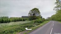
Elford Low was known as 'Robin Hood's Butt' in the 19th century and earlier / Google Earth Street View
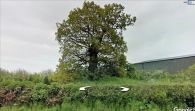
Elford Low or Robin Hood's Butt / Google Earth Street View

