
Robin Friend (Sheringham): Difference between revisions
From International Robin Hood Bibliography
mNo edit summary |
mNo edit summary |
||
| Line 1: | Line 1: | ||
__NOTOC__{{PnItemTop|Lat=52.9478|Lon=1.1917|AdmDiv=Norfolk|Vicinity=On the beach immediately north of the golf course in Sheringham|Type=Natural feature|Interest=Local tradition|Status=Extant|Demonym=|Riding=|GreaterLondon=|Year=1886|Aka=|Century=|Cluster1=|Cluster2=|Image=robin-friend-hugh-venables.jpg|Postcards=|ExtraCat1=|ExtraCat2=|ExtraCat3=|ExtraCat4=|ExtraCat5=|GeopointPrefix=|GeopointSuffix=|VicinitySuffix=|StatusSuffix=|DatePrefix=|DateSuffix=}} | __NOTOC__{{PnItemTop|Lat=52.9478|Lon=1.1917|AdmDiv=Norfolk|Vicinity=On the beach immediately north of the golf course in Sheringham|Type=Natural feature|Interest=Local tradition|Status=Extant|Demonym=|Riding=|GreaterLondon=|Year=1886|Aka=|Century=|Cluster1=|Cluster2=|Image=robin-friend-hugh-venables.jpg|Postcards=|ExtraCat1=|ExtraCat2=|ExtraCat3=|ExtraCat4=|ExtraCat5=|GeopointPrefix=|GeopointSuffix=|VicinitySuffix=|StatusSuffix=|DatePrefix=|DateSuffix=}} | ||
{{#display_map:{{#var:Coords}}|width=34%}}<div class="pnMapLegend">Robin Friend.</div> | {{#display_map:{{#var:Coords}}|width=34%}}<div class="pnMapLegend">Robin Friend.</div> | ||
[[File:robin-friend-hugh-venables.jpg|thumb|right|500px|Robin Friend is most clearly seen from a distance / | [[File:robin-friend-hugh-venables.jpg|thumb|right|500px|Robin Friend is most clearly seen from a distance / [http://www.geograph.org.uk/profile/3176 Hugh Venables, Creative Commons, via Geograph.]]] | ||
<p id="byline">By Henrik Thiil Nielsen, 2017-05-10. Revised by {{#realname:{{REVISIONUSER}}}}, {{REVISIONYEAR}}-{{REVISIONMONTH}}-{{REVISIONDAY2}}.</p><div class="no-img">'Robin Friend' is the name of an extensive exposed layer of chalk on the foreshore just north of the golf course in Sheringham and northwest of the lifeboat station, "a resistant shoal which is exposed at low spring tides". On the coast near Robin Friend rare flint ammonites can sometimes be found.<ref>[http://www.geograph.org.uk/photo/1093861 Legend to Evelyn Simak's photo at Geograph.]</ref> Dobson & Taylor note that Robin Friend appears to have been associated with the Robin Hood tradition.<ref>{{:Dobson, Richard Barrie 1976a}}, p. 300, ''s.n.'' Robin Friend.</ref> | <p id="byline">By Henrik Thiil Nielsen, 2017-05-10. Revised by {{#realname:{{REVISIONUSER}}}}, {{REVISIONYEAR}}-{{REVISIONMONTH}}-{{REVISIONDAY2}}.</p><div class="no-img">'Robin Friend' is the name of an extensive exposed layer of chalk on the foreshore just north of the golf course in Sheringham and northwest of the lifeboat station, "a resistant shoal which is exposed at low spring tides". On the coast near Robin Friend rare flint ammonites can sometimes be found.<ref>[http://www.geograph.org.uk/photo/1093861 Legend to Evelyn Simak's photo at Geograph.]</ref> Dobson & Taylor note that Robin Friend appears to have been associated with the Robin Hood tradition.<ref>{{:Dobson, Richard Barrie 1976a}}, p. 300, ''s.n.'' Robin Friend.</ref> | ||
<!--{{#ask:[[Category:Records (_PLACE-NAME)]]| format=embedded|embedformat=h4| columns=1|limit=1000|sort=Utitle}}--> | <!--{{#ask:[[Category:Records (_PLACE-NAME)]]| format=embedded|embedformat=h4| columns=1|limit=1000|sort=Utitle}}--> | ||
| Line 23: | Line 22: | ||
</div> | </div> | ||
{{ImgGalleryIntro}} | {{ImgGalleryIntro}} | ||
<gallery widths="195px"> | <gallery widths="195px"> | ||
File:robin-friend-hugh-venables.jpg|thumb|right|500px|Robin Friend is most clearly seen from a distance / [http://www.geograph.org.uk/profile/3176 Hugh Venables, Creative Commons, via Geograph.] | |||
</gallery | File:robin-friend-evelyn-simak.jpg|thumb|right|500px|Looking west toward Robin Friend. The flat darkish formation does not rise much above the exposed seabed / [http://www.geograph.org.uk/profile/14840 Evelyn Simak, Creative Commons, via Geograph.] | ||
</gallery> | |||
{{PnItemNav}} | {{PnItemNav}} | ||
Revision as of 20:07, 5 December 2017
Robin Friend.

Robin Friend is most clearly seen from a distance / Hugh Venables, Creative Commons, via Geograph.
By Henrik Thiil Nielsen, 2017-05-10. Revised by Henrik Thiil Nielsen, 2017-12-05.
'Robin Friend' is the name of an extensive exposed layer of chalk on the foreshore just north of the golf course in Sheringham and northwest of the lifeboat station, "a resistant shoal which is exposed at low spring tides". On the coast near Robin Friend rare flint ammonites can sometimes be found.[1] Dobson & Taylor note that Robin Friend appears to have been associated with the Robin Hood tradition.[2]
Gazetteers
- Dobson, R. B., ed.; Taylor, J., ed. Rymes of Robyn Hood: an Introduction to the English Outlaw (London, 1976), p. 300, s.n. Robin Friend.
Maps
- 6" O.S. map Norfolk X.NE (1886; surveyed 1886)
- 6" O.S. map Norfolk X.NE (1907; rev. 1906)
- 6" O.S. map Norfolk X.NE (1907; rev. 1906) (georeferenced)
- 6" O.S. map Norfolk X.NE (1929; rev. 1926-27)
- 6" O.S. map Norfolk X.NE (1944; rev. 1938).
Background
- Discovering Britain: Very flat, Norfolk (PDF brochure)
- Norfolk Museums: Weybourne – Sheringham: Geology.
Notes
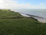
Robin Friend is most clearly seen from a distance / Hugh Venables, Creative Commons, via Geograph.
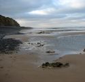
Looking west toward Robin Friend. The flat darkish formation does not rise much above the exposed seabed / Evelyn Simak, Creative Commons, via Geograph.
