
Plumpton Park (Worsbrough)
[[File:|thumb|right|500px|The trees beyond the lawn and immediately NE of it stand in what was once a close known as Plumpton Park / Google Earth Street View.]]

By Henrik Thiil Nielsen, 2020-07-19. Revised by Henrik Thiil Nielsen, 2020-07-19.
In the Gest, King Edward is exasperated at noticing the scarcity of deer in Plumpton Park after Robin and his men have been poaching there during their stay with the knight. We should almost certainly take this to be in Lancashire, but it is perhaps worth noting that Plumpton Park occurs as a field name in Worsbrough, formerly in the West Riding of Yorkshire. The source is an 1838 tithe award.
In the tithe award for the township of Worsbrough in the parish of Darfield, drawn up in 1838, Plumpton Park is listed as grassland with an area of 1 rood and 29 perches (Template:AcreRoodPerchToM2 m2). Its occupier was a Joseph Swiift, the owner a William Bennet Martin, Esq.[1] Template:PnItemQry
Quotations
[Gest; c. 1500:]
All the passe of Lancasshyre
He went both ferre and nere
Tyll he came to Plomton Parke
He faylyd many of his dere.[2]
Gazetteers
- Not included in Dobson, R. B., ed.; Taylor, J., ed. Rymes of Robyn Hood: an Introduction to the English Outlaw (London, 1976), pp. 293-311.
Sources
- The Genealogist, Piece 043, Sub-Piece 443, Sub-Image 456, Plot 285; 1838 Worsbrough tithe award (subscription required)
- The Genealogist, Piece 043, Sub-Piece 443, Sub-Image 001, Plot 285; 1838 Worsbrough tithe award map (subscription required).
Maps
- 25" O.S. map Yorkshire CCLXXXII.3 (1893; surveyed 1891)
- 25" O.S. map Yorkshire CCLXXXII.3 (1931; rev. 1929)
- 25" O.S. map Yorkshire CCLXXXII.3 (1906; rev. 1903) (georeferenced)
- 25" O.S. map Yorkshire CCLXXXII.3 (1906; rev. 1903)
- 6" O.S. map Yorkshire 282 (1855; surveyed 1850–51)
- 6" O.S. map Yorkshire CCLXXXII.NE (1893–94; surveyed 1890
- 6" O.S. map Yorkshire CCLXXXII.NE (1907; rev. 1903) (georeferenced)
- 6" O.S. map Yorkshire CCLXXXII.NE (1907; rev. 1903)
- 6" O.S. map Yorkshire CCLXXXII.NE (1932; rev. 1929)
- 6" O.S. map Yorkshire CCLXXXII.NE (1948; rev. 1938)
- 6" O.S. map Yorkshire CCLXXXII.NE (1949; rev. 1948).
Notes
- ↑ The Genealogist, Piece 043, Sub-Piece 443, Sub-Image 456, Plot 285; 1838 Worsbrough tithe award; The Genealogist, Piece 043, Sub-Piece 443, Sub-Image 001, Plot 285; 1838 Worsbrough tithe award map (subscription required).
- ↑ Gest, st. 357.
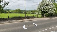
The trees beyond the lawn and immediately NE of it stand in what was once a close known as Plumpton Park / Google Earth Street View.
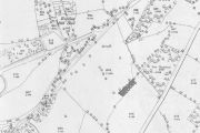
The gray area approximately indicates, the size, shape and location of Plumpton Park in 1838 / Reproduced with the permission of the National Library of Scotland; Creative Commons.
