
Loxley (river): Difference between revisions
mNo edit summary |
m (Text replacement - "ImgGalleryIntro" to "ImageGalleryIntroduction") |
||
| (42 intermediate revisions by 2 users not shown) | |||
| Line 1: | Line 1: | ||
__NOTOC__ | __NOTOC__{{PlaceNamesItemTop|Lat=53.410556|Lon=-1.571111|AdministrativeDivision=Yorkshire|Vicinity=Sheffield|Type=Natural feature|Interest=Literary locale|Status=Extant|Demonym=|Riding=West|GreaterLondon=|Year=1650|Aka=|Century=|Cluster1=Loxley|Cluster2=|Cluster3=|Image=loxley_terry_robinson.jpg|Postcards=|ExtraCat1=Places named Loxley|ExtraCat2=|ExtraCat3=|ExtraCat4=|ExtraCat5=|GeopointPrefix=|GeopointSuffix=|StatusSuffix=|DatePrefix=''c. ''|DateSuffix=}} | ||
{{ | {{#display_map:{{#var:Coords}}~River Loxley, origin;53.400526,-1.486888~River Loxley, mouth|width=34%|enablefullscreen=yes}}<div class="pnMapLegend">The left marker indicates approximately the origin of River Loxley, the right marker its mouth.</div> | ||
[[File:loxley_terry_robinson.jpg|thumb|right|500px|River Loxley / [http://www.geograph.org.uk/photo/1014792 Terry Robinson].]]<div class="no-img"> | |||
<p id="byline">By Henrik Thiil Nielsen, 2014-09-20. Revised by {{#realname:{{REVISIONUSER}}}}, {{REVISIONYEAR}}-{{REVISIONMONTH}}-{{REVISIONDAY2}}.</p> | |||
River Loxley is an affluent of the Rivelin near Bradfield and Sheffield. Its sources are located c. 16 km NW of Sheffield on Bradfield Moors; it flows easterly through Damflask Reservoir and is joined by Storrs Brook at Storrs near Stannington and the Rivelin at Malin Bridge before flowing into the Don at Owlerton in Hillsborough. The total length of the river is about 10 km. According to A. H. Smith the river was almost certainly named after the [[Loxley (Sheffield)|village or area of the same name near Sheffield]]<ref>{{:Smith, Albert Hugh 1961a}}, vol. VII, p. 131.</ref> which is often said to be the Loxley connected with Robin Hood. At the most, therefore, its connction with the outlaw tradition is indirect.{{PlaceNamesItemAllusionsAndRecords}} | |||
== Gazetteers == | |||
}} | |||
{{#display_map: | |||
[[File:loxley_terry_robinson.jpg|thumb|right|500px|River Loxley | |||
<p id="byline">By Henrik Thiil Nielsen, 2014-09-20. Revised by {{#realname:{{REVISIONUSER}}}}, {{REVISIONYEAR}}-{{REVISIONMONTH}}-{{REVISIONDAY2}}.</p | |||
River Loxley is an affluent of the Rivelin near Bradfield and Sheffield. Its sources are located c. 16 km NW of Sheffield on Bradfield Moors; it flows easterly through Damflask Reservoir and is joined by Storrs Brook at Storrs near Stannington and the Rivelin at Malin Bridge before flowing into the Don at Owlerton in Hillsborough. The total length of the river is about 10 km. According to A.H. Smith the river was almost certainly named after the [[Loxley (Sheffield)|village or area of the same name near Sheffield]]<ref>{{:Smith, Albert Hugh 1961a}}, vol. VII, p. 131.</ref> which is often said to be the Loxley connected with Robin Hood. At the most, therefore, its connction with the outlaw tradition is indirect. | |||
{{ | |||
* Not included in {{:Dobson, Richard Barrie 1976a}}, pp. 293-311. | * Not included in {{:Dobson, Richard Barrie 1976a}}, pp. 293-311. | ||
== Sources == | |||
* {{:Smith, Albert Hugh 1961a}}, vol. VII, p. 131. | * {{:Smith, Albert Hugh 1961a}}, vol. VII, p. 131. | ||
== Maps == | |||
* [http://maps.nls.uk/view/102345217#zoom=6&lat=9552&lon=3384&layers=BT 6" O.S. map ''Yorkshire'' 294 (1855; surveyed 1850-51)] | * [http://maps.nls.uk/view/102345217#zoom=6&lat=9552&lon=3384&layers=BT 6" O.S. map ''Yorkshire'' 294 (1855; surveyed 1850-51)] | ||
* [http://maps.nls.uk/view/100950065#zoom=5&lat=5126&lon=5504&layers=BT 6" O.S. map ''Yorkshire'' CCXCIV.NW (1894; surveyed 1890)] | * [http://maps.nls.uk/view/100950065#zoom=5&lat=5126&lon=5504&layers=BT 6" O.S. map ''Yorkshire'' CCXCIV.NW (1894; surveyed 1890)] | ||
| Line 42: | Line 20: | ||
* [http://maps.nls.uk/view/100950050#zoom=5&lat=5196&lon=4807&layers=BT 6" O.S. map ''Yorkshire'' CCXCIV.NW (1949; rev. 1948).] | * [http://maps.nls.uk/view/100950050#zoom=5&lat=5196&lon=4807&layers=BT 6" O.S. map ''Yorkshire'' CCXCIV.NW (1949; rev. 1948).] | ||
== Background == | |||
* [http://en.wikipedia.org/wiki/River_Loxley Wikipedia: River Loxley.] | * [http://en.wikipedia.org/wiki/River_Loxley Wikipedia: River Loxley.] | ||
{{PlaceNamesItemAlsoSee}} | |||
== Notes == | |||
<references/> | <references/> | ||
</div> | |||
<div id="gallery"> | |||
{{ImageGalleryIntroduction}} | |||
<gallery widths="195px"> | |||
File:loxley_terry_robinson.jpg|River Loxley / [http://www.geograph.org.uk/photo/1014792 Terry Robinson.] | |||
File:loxley_weir_terry_robinson.jpg|River Loxley / [http://www.geograph.org.uk/photo/1014794 Terry Robinson.] | |||
</gallery> | |||
</div> | </div> | ||
{{ | {{PlaceNamesItemNavigation}} | ||
Revision as of 13:50, 7 January 2021
| Locality | |
|---|---|
| Coordinate | 53.410556, -1.571111 |
| Adm. div. | West Riding of Yorkshire |
| Vicinity | Sheffield |
| Type | Natural feature |
| Interest | Literary locale |
| Status | Extant |
| First Record | c. 1650 |

By Henrik Thiil Nielsen, 2014-09-20. Revised by Henrik Thiil Nielsen, 2021-01-07.
River Loxley is an affluent of the Rivelin near Bradfield and Sheffield. Its sources are located c. 16 km NW of Sheffield on Bradfield Moors; it flows easterly through Damflask Reservoir and is joined by Storrs Brook at Storrs near Stannington and the Rivelin at Malin Bridge before flowing into the Don at Owlerton in Hillsborough. The total length of the river is about 10 km. According to A. H. Smith the river was almost certainly named after the village or area of the same name near Sheffield[1] which is often said to be the Loxley connected with Robin Hood. At the most, therefore, its connction with the outlaw tradition is indirect.
Gazetteers
- Not included in Dobson, R. B., ed.; Taylor, J., ed. Rymes of Robyn Hood: an Introduction to the English Outlaw (London, 1976), pp. 293-311.
Sources
- Smith, A.H. The Place-Names of the West Riding of Yorkshire (English Place-Name Society, vols. XXX-XXXVII) (Cambridge, 1961-63), vol. VII, p. 131.
Maps
- 6" O.S. map Yorkshire 294 (1855; surveyed 1850-51)
- 6" O.S. map Yorkshire CCXCIV.NW (1894; surveyed 1890)
- 6" O.S. map Yorkshire CCXCIV.NW (1906; rev. 1901-1903)
- 6" O.S. map Yorkshire CCXCIV (1924; rev. 1920-21)
- 6" O.S. map Yorkshire CCXCIV.NW (1924; rev. 1924)
- 6" O.S. map Yorkshire CCXCIV.NW (1939; rev. 1934-35)
- 6" O.S. map Yorkshire CCXCIV.NW (1947; rev. 1938)
- 6" O.S. map Yorkshire CCXCIV.NW (1949; rev. 1948).
Background
Also see
Notes
Image gallery
Click any image to display it in the lightbox, where you can navigate between images by clicking in the right or left side of the current image.
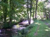
River Loxley / Terry Robinson.
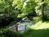
River Loxley / Terry Robinson.
