
Little Johns (Margaretting)
From International Robin Hood Bibliography
| Locality | |
|---|---|
| Coordinate | 51.699, 0.4355 |
| Adm. div. | Essex |
| Vicinity | East side of A414 (Three Mile Hill); c. 1 km NE of Margaretting |
| Type | Area |
| Interest | Robin Hood name |
| Status | Defunct? |
| First Record | 1837 |
Little Johns, Margaretting.

By Henrik Thiil Nielsen, 2018-02-21. Revised by Henrik Thiil Nielsen, 2021-02-12.
The 1837 tithe award for Margaretting lists 'Little Johns' as the name of a close on the east side of the A414 (Three Mile Hill), c. 1 km NE of Margaretting. Its owner/occupier is listed as George Straight, its state of cultivation as 'Ara[ble].', its area as 1 acre, 3 roods and 14 perches (7436.1 m2).[1]
Gazetteers
- Not included in Dobson, R. B., ed.; Taylor, J., ed. Rymes of Robyn Hood: an Introduction to the English Outlaw (London, 1976); see pp. 293-311.
MS sources
- Tithe award for Margaretting, online at the Genealogist, Piece 12, Sub-Piece 222, Image 17 (£)
- Accompanying map, online at the Genealogist, Piece 12, Sub-Piece 222, Sub-Image 001 (£).
Printed sources
Maps
Little Johns not labelled.
- 25" O.S. map Essex LII.15 (1896; rev. 1895) (georeferenced)
- 6" O.S. map Essex LII (1881; surveyed 1874)
- 6" O.S. map Essex LII.SE (1896; rev. 1895) (georeferenced)
- 1:1 million-1:10k (1900s) (georeferenced)
- Chelmsford (Outline), Sheet 241 (1896; rev. 1893) (georeferenced)
- Chelmsford (Hills), Sheet 241 (1896; rev. 1893) (georeferenced)
- 1/2" Bartholomew, Sheet 26, Essex (1903) (georeferenced)
- 6" O.S. map Essex nLXIII.NW (1923; rev. 1919)
- 6" O.S. map Essex nLXIII.NW (1924; rev. 1919)
- 6" O.S. map Essex nLXIII.NW (c. 1946; rev. 1938)
- 1/2" Bartholomew, Sheet 16, Essex (1943) (georeferenced)
- 1" O:S. map London.NE (1960; 1954-60) (georeferenced).
Background
Also see
Notes
- ↑ Tithe award for Margaretting, online at the Genealogist, Piece 12, Sub-Piece 222, Image 17 (£); Genealogist, Piece 12, Sub-Piece 222, Sub-Image 001; map (£). Waller, William Chapman, compil. 'Essex Field Names: Part VIII.—The Hundred of Chelmsford', Transactions of the Essex Archæological Society, New Series, vol. IX (1903), pp. 156-179; see pp. 157, 170.
Image gallery
Click any image to display it in the lightbox, where you can navigate between images by clicking in the right or left side of the current image.
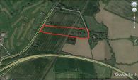
Little Johns, Margaretting (red outline) / Google Earth Street View.
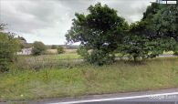
A peek from the A414 across the street into the (former?) Little Johns / Google Earth Street View.
