
Little Johns (Blackmore): Difference between revisions
From International Robin Hood Bibliography
m (Text replacement - "<h3>Allusions</h3>" to "<h2>Allusions</h2>") |
m (Text replacement - "=== Printed sources ===" to "== Printed sources ==") |
||
| Line 12: | Line 12: | ||
* Accompanying map, online at the [https://www.thegenealogist.co.uk/ Genealogist.co.uk], Piece 12, Sub-Piece 039, Sub-Image 001 (requires paid subscription). | * Accompanying map, online at the [https://www.thegenealogist.co.uk/ Genealogist.co.uk], Piece 12, Sub-Piece 039, Sub-Image 001 (requires paid subscription). | ||
== Printed sources == | |||
* {{:Waller, William Chapman 1903b}}; see pp. 157, 170. | * {{:Waller, William Chapman 1903b}}; see pp. 157, 170. | ||
Revision as of 15:36, 12 July 2018
Little Johns, Blackmore.
[[File:|thumb|right|500px|Little Johns, Blackmore (red outline), / Google Earth Street View.]]
By Henrik Thiil Nielsen, 2018-02-20. Revised by Henrik Thiil Nielsen, 2018-07-12.
The 1845 tithe award for Blackmore lists 'Little Johns' as the name of a close immediately west of Fryerning Wood. Its owner is listed as Thomas John Mattham, occupier as William Lawrence, state of cultivation as 'Pasture', area as 3 acres, state of cultivation as 'Pas[ture]', 2 roods and 1 perches (Template:AcreRoodPerchToM2 m2).[1]
Gazetteers
- Not included in Dobson, R. B., ed.; Taylor, J., ed. Rymes of Robyn Hood: an Introduction to the English Outlaw (London, 1976), pp. 293-311.
MS sources
- Tithe award for Blackmore, online at the Genealogist.co.uk, Piece 12, Sub-Piece 039, Image 017 (requires paid subscription)
- Accompanying map, online at the Genealogist.co.uk, Piece 12, Sub-Piece 039, Sub-Image 001 (requires paid subscription).
Printed sources
Maps
Little Johns not labelled.
- 25" O.S. map Essex LIX.4 (1897; rev. 1895) (georeferenced)
- 6" O.S. map Essex LIX (1881; surveyed 1871-73)
- 6" O.S. map Essex LIX.NE (1898; rev. 1895)
- 6" O.S. map Essex LIX.NE (1898; rev. 1895) (georeferenced)
- 6" O.S. map Essex nLXII (1923; rev. 1915-18)
- 1:25,000 O.S. map TL60 (1958; surveyed 1938-55) (georeferenced)
- 1:1 million–1:10k (1900s) (georeferenced).
Background
Notes
- ↑ Tithe award for Blackmore, online at the Genealogist.co.uk, Piece 12, Sub-Piece 039, Image 017 (requires paid subscription); Genealogist.co.uk, Piece 12, Sub-Piece 039, Sub-Image 001; map (requires paid subscription). Waller, William Chapman, compil. 'Essex Field Names: Part VIII.—The Hundred of Chelmsford', Transactions of the Essex Archæological Society, New Series, vol. IX (1903), pp. 156-179; see pp. 157, 170.
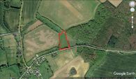
The Little Johns (red outline) / Google Earth Street View.
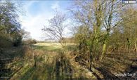
A peep into the (former?) Little Johns / Google Earth Street View.

