
Little John Meadow (Rivenhall): Difference between revisions
(Created page with "__NOTOC__{{PnItemTop|Lat=51.8211|Lon=0.6611|AdmDiv=Essex|Vicinity=East of Oak Road, north of railroad tracks|Type=Area|Interest=Robin Hood name| Status=Defunct|Demonym=English...") |
mNo edit summary |
||
| Line 4: | Line 4: | ||
[[File:{{#var:Pnimage}}|thumb|right|500px|Little John's Meadow, Rivenhall (red outline), / Google Earth Street View.]] | [[File:{{#var:Pnimage}}|thumb|right|500px|Little John's Meadow, Rivenhall (red outline), / Google Earth Street View.]] | ||
<p id="byline">By Henrik Thiil Nielsen, 2018-02-20. Revised by {{#realname:{{REVISIONUSER}}}}, {{REVISIONYEAR}}-{{REVISIONMONTH}}-{{REVISIONDAY2}}.</p><div class="no-img"> | <p id="byline">By Henrik Thiil Nielsen, 2018-02-20. Revised by {{#realname:{{REVISIONUSER}}}}, {{REVISIONYEAR}}-{{REVISIONMONTH}}-{{REVISIONDAY2}}.</p><div class="no-img"> | ||
The 1838 tithe award for Rivenhall lists 'Little John Meadow' as the name of a close east of Oak | The 1838 tithe award for Rivenhall lists 'Little John Meadow' as the name of a close east of Oak Road and north of the railroad tracks in Rivenhall. Its owner/occupier is listed as George Clapham, Esq., its state of cultivation as 'Pasture', its area as 7 acres, 1 rood and 33 perches ({{AcreRoodPerchToM2|7|1|33}} m<sup>2</sup>).<ref>Tithe award for Rivenhall, online at the [https://www.thegenealogist.co.uk/ Genealogist.co.uk], Piece 12, Sub-Piece 280, Image 010 (requires paid subscription); [https://www.thegenealogist.co.uk/ Genealogist.co.uk], Piece 12, Piece 12, Sub-Piece 280, Sub-Image 001; map (requires paid subscription). {{:Waller, William Chapman 1903a}}; see pp. 69, 84.</ref>{{#ask:[[Category:Records ({{#ifeq:{{#pos:{{PAGENAME}}|(|}}||{{PAGENAME}}|{{#sub:{{PAGENAME}}|0| {{#expr:{{#pos:{{PAGENAME}}|(|}}-1}} }},{{#sub:{{PAGENAME}}|{{#expr:{{#pos:{{PAGENAME}}|(|}}-1}}|1}}{{#sub:{{PAGENAME}}|{{#expr:{{#pos:{{PAGENAME}}|(|}}+1}}}}}}]]| format=embedded|embedformat=h4|columns=1|limit=1000|sort=Utitle|intro=<h3>Records</h3>}} | ||
{{#ask:[[Category:Allusions ({{#ifeq:{{#pos:{{PAGENAME}}|(|}}||{{PAGENAME}}|{{#sub:{{PAGENAME}}|0| {{#expr:{{#pos:{{PAGENAME}}|(|}}-1}} }},{{#sub:{{PAGENAME}}|{{#expr:{{#pos:{{PAGENAME}}|(|}}-1}}|1}}{{#sub:{{PAGENAME}}|{{#expr:{{#pos:{{PAGENAME}}|(|}}+1}}}}}}]]| format=embedded|embedformat=h4|columns=1|limit=1000|sort=Utitle|intro=<h3>Allusions</h3>}} | {{#ask:[[Category:Allusions ({{#ifeq:{{#pos:{{PAGENAME}}|(|}}||{{PAGENAME}}|{{#sub:{{PAGENAME}}|0| {{#expr:{{#pos:{{PAGENAME}}|(|}}-1}} }},{{#sub:{{PAGENAME}}|{{#expr:{{#pos:{{PAGENAME}}|(|}}-1}}|1}}{{#sub:{{PAGENAME}}|{{#expr:{{#pos:{{PAGENAME}}|(|}}+1}}}}}}]]| format=embedded|embedformat=h4|columns=1|limit=1000|sort=Utitle|intro=<h3>Allusions</h3>}} | ||
=== Gazetteers === | === Gazetteers === | ||
| Line 14: | Line 14: | ||
=== Printed sources === | === Printed sources === | ||
* {{:Waller, William Chapman | * {{:Waller, William Chapman 1903a}}; see pp. 69, 84. | ||
=== Maps === | === Maps === | ||
| Line 39: | Line 39: | ||
{{ImgGalleryIntro}} | {{ImgGalleryIntro}} | ||
<gallery widths="195px"> | <gallery widths="195px"> | ||
File:little- | File:geograph-263567-by-Robert-Edwards.jpg|Lane leading to Hoo Hall. The sunlit section of the fence in the distance is at the northern perimeter of the area that is or was known as Little John Meadow / [http://www.geograph.org.uk/photo/263567 Robert Edwards, 20 Oct. 2006, Creative Commons, via Geograph.] | ||
File:little- | File:little-john-meadow-rivenhall-google-earth-street-view-2.jpg|The (former?) Little John Meadow seen from Oak Road near the railroad tracks / Google Earth Street View. | ||
File:little-john-meadow-rivenhall-google-earth-street-view.jpg|Little John Meadow (red outline) / Google Earth Street View. | |||
</gallery> | </gallery> | ||
{{PnItemNav}} | {{PnItemNav}} | ||
Revision as of 21:10, 20 February 2018
[[File:|thumb|right|500px|Little John's Meadow, Rivenhall (red outline), / Google Earth Street View.]]
By Henrik Thiil Nielsen, 2018-02-20. Revised by Henrik Thiil Nielsen, 2018-02-20.
The 1838 tithe award for Rivenhall lists 'Little John Meadow' as the name of a close east of Oak Road and north of the railroad tracks in Rivenhall. Its owner/occupier is listed as George Clapham, Esq., its state of cultivation as 'Pasture', its area as 7 acres, 1 rood and 33 perches (Template:AcreRoodPerchToM2 m2).[1]
Gazetteers
- Not included in Dobson, R. B., ed.; Taylor, J., ed. Rymes of Robyn Hood: an Introduction to the English Outlaw (London, 1976), pp. 293-311.
MS sources
- Tithe award for Rivenhall, online at the Genealogist.co.uk, Piece 12, Sub-Piece 280, Image 010 (requires paid subscription)
- Accompanying map, online at the Genealogist.co.uk, Piece 12, Sub-Piece 280, Sub-Image 001 (requires paid subscription).
Printed sources
Maps
Little John's Mead not labelled.
- 25" O.S. map Essex LXXV.5 (1897; rev. 1895)
- 25" O.S. map Essex LXXV.5 (1897; rev. 1895) (georeferenced)
- 6" O.S. map Essex LXXV.NW (1898; rev. 1895)
- 6" O.S. map Essex LXXV.NW (1898; rev. 1895) (georeferenced)
- 6" O.S. map Essex nLXXXVII.NE (1921; rev. 1915)
- 6" O.S. map Essex nLXXXVII.NE (c. 1945; rev. 1938)
- 1:25,000 O.S. map TQ58 (1959; surveyed 1938-55) (georeferenced)
- 1:1 million–1:10k (1900s) (georeferenced).
Background
Notes
- ↑ Tithe award for Rivenhall, online at the Genealogist.co.uk, Piece 12, Sub-Piece 280, Image 010 (requires paid subscription); Genealogist.co.uk, Piece 12, Piece 12, Sub-Piece 280, Sub-Image 001; map (requires paid subscription). Waller, William Chapman, compil. 'Essex Field Names: Part VIII.—The Hundreds of Dunmow and Witham', Transactions of the Essex Archæological Society, New Series, vol. IX (1903), pp. 68-100; see pp. 69, 84.
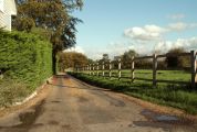
Lane leading to Hoo Hall. The sunlit section of the fence in the distance is at the northern perimeter of the area that is or was known as Little John Meadow / Robert Edwards, 20 Oct. 2006, Creative Commons, via Geograph.
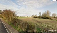
The (former?) Little John Meadow seen from Oak Road near the railroad tracks / Google Earth Street View.
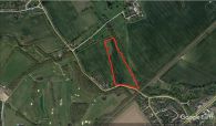
Little John Meadow (red outline) / Google Earth Street View.


