
Little John Field (Hebden): Difference between revisions
m (Text replacement - "== MS sources === " to "== MS sources == ") |
m (Text replacement - "(subscription required)" to "(£)") |
||
| (13 intermediate revisions by the same user not shown) | |||
| Line 1: | Line 1: | ||
__NOTOC__{{ | __NOTOC__{{PlaceNamesItemTop|Lat=54.0559|Lon=-1.9566|AdministrativeDivision=Yorkshire|Vicinity=E side of Burnsall Lane, ''c.'' 700 m SE of Hebden|Type=Area|Interest=Robin Hood name| | ||
Status=Defunct|Demonym=|Riding=West|GreaterLondon=|Year=1846|Aka=|Century=|Cluster1=|Cluster2=|Cluster3=|Image=google-earth-street-view-little-john-field-hebden-1.jpg|Postcards=|ExtraCat1=Places named after Little John|ExtraCat2=|ExtraCat3=|ExtraCat4=|ExtraCat5=|ExtraLink1=|ExtraLink2=|ExtraLink3=|ExtraLink4=|ExtraLink5=|ExtraLinkName1=|ExtraLinkName2=|ExtraLinkName3=|ExtraLinkName4=|ExtraLinkName5=|GeopointPrefix=|GeopointSuffix=|VicinitySuffix=|StatusSuffix=?|DatePrefix=|DateSuffix=}} | Status=Defunct|Demonym=|Riding=West|GreaterLondon=|Year=1846|Aka=|Century=|Cluster1=|Cluster2=|Cluster3=|Image=google-earth-street-view-little-john-field-hebden-1.jpg|Postcards=|ExtraCat1=Places named after Little John|ExtraCat2=|ExtraCat3=|ExtraCat4=|ExtraCat5=|ExtraLink1=|ExtraLink2=|ExtraLink3=|ExtraLink4=|ExtraLink5=|ExtraLinkName1=|ExtraLinkName2=|ExtraLinkName3=|ExtraLinkName4=|ExtraLinkName5=|GeopointPrefix=|GeopointSuffix=|VicinitySuffix=|StatusSuffix=?|DatePrefix=|DateSuffix=}} | ||
{{#display_map:{{#var:Coords}}~{{#replace:{{PAGENAME}}|'|'}}|width=34%}}<div class="pnMapLegend">A close (formerly?) known as Little John Field.</div> | {{#display_map:{{#var:Coords}}~{{#replace:{{PAGENAME}}|'|'}}|width=34%|fullscreen=yes}}<div class="pnMapLegend">A close (formerly?) known as Little John Field.</div> | ||
[[File:{{#var: | [[File:{{#var:Image}}|thumb|right|500px|The (former?) Little John Field / Google Earth Street View.]]<div class="no-img"> | ||
<p id="byline">By Henrik Thiil Nielsen, 2020-04-29. Revised by {{#realname:{{REVISIONUSER}}}}, {{REVISIONYEAR}}-{{REVISIONMONTH}}-{{REVISIONDAY2}}.</p | <p id="byline">By Henrik Thiil Nielsen, 2020-04-29. Revised by {{#realname:{{REVISIONUSER}}}}, {{REVISIONYEAR}}-{{REVISIONMONTH}}-{{REVISIONDAY2}}.</p> | ||
A close on the east side of Burnsall Lane, ''c.'' 700 m SE of Hebden, is or was once known as 'Little John Field'. | A close on the east side of Burnsall Lane, ''c.'' 700 m SE of Hebden, is or was once known as 'Little John Field'. | ||
The field name occurs in the tithe award for Hebden (1846), where it and a larger neighbouring piece, 'John Field', are listed with Sarah Chamberlain as owner and Thomas Stockdale as occupier. The smaller piece is listed with an area of 1 acre and 2 perches ({{ | The field name occurs in the tithe award for Hebden (1846), where it and a larger neighbouring piece, 'John Field', are listed with Sarah Chamberlain as owner and Thomas Stockdale as occupier. The smaller piece is listed with an area of 1 acre and 2 perches ({{AcresRoodsPerchesToM2|1|0|2}} m<sup>2</sup>), the larger with 5 acres, 3 roods and 14 perches ({{AcresRoodsPerchesToM2|5|3|14}} m<sup>2</sup>). For both fields 'Meadow' is entered under 'State of Cultivation'.<ref>1846 tithe award for Hebden in the parish of Linton, online at the [https://www.thegenealogist.com Genealogist.com], piece 43, sub-piece 205, image 010, items #471 and #472; accompanying map, online at the [https://www.thegenealogist.com Genealogist.com], piece 43, sub-piece 205, sub-image 003 (£).</ref> The closes likely belong (and belonged) to the nearby Rainlands Farm, which figures on old OS maps as 'Rainlands House' or 'Rainlands' ''tout court''. These two Johns are not labelled on O.S. maps which, however, include 'John Lathe' which sits on a field immediately NE of John Field. | ||
Formerly in the West Riding, Hebden now belongs administratively to North Yorkshire.{{ | Formerly in the West Riding, Hebden now belongs administratively to North Yorkshire.{{PlaceNamesItemAllusionsAndRecords}} | ||
== Gazetteers == | == Gazetteers == | ||
* Not included in {{:Dobson, Richard Barrie 1976a}}, pp. 293-311. | * Not included in {{:Dobson, Richard Barrie 1976a}}, pp. 293-311. | ||
== MS sources == | == MS sources == | ||
* 1846 tithe award for Hebden in the parish of Linton, online at the [https://www.thegenealogist.com Genealogist.com], piece 43, sub-piece 205, image 010, items #471 and #472 ( | * 1846 tithe award for Hebden in the parish of Linton, online at the [https://www.thegenealogist.com Genealogist.com], piece 43, sub-piece 205, image 010, items #471 and #472 (£) | ||
* accompanying map, online at the [https://www.thegenealogist.com Genealogist.com], piece 43, sub-piece 205, sub-image 003 ( | * accompanying map, online at the [https://www.thegenealogist.com Genealogist.com], piece 43, sub-piece 205, sub-image 003 (£). | ||
== Maps == | == Maps == | ||
| Line 31: | Line 31: | ||
<!--== Brief mention == | <!--== Brief mention == | ||
* --> | * --> | ||
{{ | {{PlaceNamesItemAlsoSee}} | ||
== Notes == | == Notes == | ||
| Line 38: | Line 38: | ||
<div id="gallery"> | <div id="gallery"> | ||
{{ | {{ImageGalleryIntroduction}} | ||
<gallery widths="195px"> | <gallery widths="195px"> | ||
google-earth-street-view-little-john-field-hebden-1.jpg|The (former?) Little John Field / Google Earth Street View. | google-earth-street-view-little-john-field-hebden-1.jpg|The (former?) Little John Field / Google Earth Street View. | ||
| Line 45: | Line 45: | ||
</div> | </div> | ||
{{ | {{PlaceNamesItemNavigation}} | ||
Revision as of 03:48, 12 February 2021
| Locality | |
|---|---|
| Coordinate | 54.0559, -1.9566 |
| Adm. div. | West Riding of Yorkshire |
| Vicinity | E side of Burnsall Lane, c. 700 m SE of Hebden |
| Type | Area |
| Interest | Robin Hood name |
| Status | Defunct? |
| First Record | 1846 |

By Henrik Thiil Nielsen, 2020-04-29. Revised by Henrik Thiil Nielsen, 2021-02-12.
A close on the east side of Burnsall Lane, c. 700 m SE of Hebden, is or was once known as 'Little John Field'.
The field name occurs in the tithe award for Hebden (1846), where it and a larger neighbouring piece, 'John Field', are listed with Sarah Chamberlain as owner and Thomas Stockdale as occupier. The smaller piece is listed with an area of 1 acre and 2 perches (4097.44 m2), the larger with 5 acres, 3 roods and 14 perches (23623.52 m2). For both fields 'Meadow' is entered under 'State of Cultivation'.[1] The closes likely belong (and belonged) to the nearby Rainlands Farm, which figures on old OS maps as 'Rainlands House' or 'Rainlands' tout court. These two Johns are not labelled on O.S. maps which, however, include 'John Lathe' which sits on a field immediately NE of John Field.
Formerly in the West Riding, Hebden now belongs administratively to North Yorkshire.
Gazetteers
- Not included in Dobson, R. B., ed.; Taylor, J., ed. Rymes of Robyn Hood: an Introduction to the English Outlaw (London, 1976), pp. 293-311.
MS sources
- 1846 tithe award for Hebden in the parish of Linton, online at the Genealogist.com, piece 43, sub-piece 205, image 010, items #471 and #472 (£)
- accompanying map, online at the Genealogist.com, piece 43, sub-piece 205, sub-image 003 (£).
Maps
- 25" O.S. map Yorkshire CXXXIV.11 (1891; surveyed 1890)
- 25" O.S. map Yorkshire CXXXIV.11 (1909, rev. 1907) (georeferenced)
- 25" O.S. map Yorkshire CXXXIV.11 (1909; rev. 1907)
- 6" O.S. map Yorkshire 134 (1853; surveyed 1848-1850)
- 6" O.S. map Yorkshire CXXXIV (1894; surveyed 1889-1890)
- 6" O.S. map Yorkshire CXXXIV.SE (1911; rev. 1907) (georeferenced)
- 6" O.S. map Yorkshire CXXXIV.SE (1911; rev. 1907).
Also see
Notes
- ↑ 1846 tithe award for Hebden in the parish of Linton, online at the Genealogist.com, piece 43, sub-piece 205, image 010, items #471 and #472; accompanying map, online at the Genealogist.com, piece 43, sub-piece 205, sub-image 003 (£).
Image gallery
Click any image to display it in the lightbox, where you can navigate between images by clicking in the right or left side of the current image.
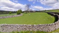
The (former?) Little John Field / Google Earth Street View.
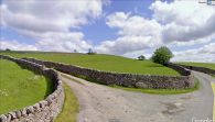
The (former?) John Field, with its Little John brother to the left / Google Earth Street View.
