Little John's Well (Stanbury): Difference between revisions
From International Robin Hood Bibliography
mNo edit summary |
mNo edit summary |
||
| Line 14: | Line 14: | ||
* [http://megalithix.wordpress.com/2009/02/23/robin-hoods-well-stanbury Robin Hood’s Well, Stanbury Moor, West Yorkshire] | * [http://megalithix.wordpress.com/2009/02/23/robin-hoods-well-stanbury Robin Hood’s Well, Stanbury Moor, West Yorkshire] | ||
* {{:Sutcliffe, Halliwell 1899a}}. | * {{:Sutcliffe, Halliwell 1899a}}. | ||
=== Maps === | |||
* [http://maps.nls.uk/geo/explore/#zoom=16&lat=53.8245&lon=-2.0294&layers=168&b=1 25" O.S. maps] (no map overlays as of 1 Jan. 20118) (georeferenced) | |||
* [http://maps.nls.uk/view/102344902#zoom=7&lat=3149&lon=14466&layers=BT 6" O.S. map ''Yorkshire'' 199 (1851; surveyed 1848)] | |||
* [http://maps.nls.uk/view/101101724#zoom=4&lat=5093&lon=5731&layers=BT 6" O.S. map ''Lancashire'' LVII.SE (1895: rev. 1892)] (springs indicated without labels) | |||
* [http://maps.nls.uk/view/100946396#zoom=5&lat=3749&lon=7735&layers=BT 6" O.S. map ''Yorkshire'' CXCIX.SW & SE (1896; surveyed 1892)] | |||
* [http://maps.nls.uk/view/100946393#zoom=5&lat=3676&lon=7545&layers=BT 6" O.S. map ''Yorkshire'' CXCIX.SW & SE (1910; rev. 1906)] | |||
* [http://maps.nls.uk/view/101101721#zoom=5&lat=5565&lon=6094&layers=BT 6" O.S. map ''Lancashire'' LVII.SE (1915: rev. 1909-10)] | |||
* [http://maps.nls.uk/geo/explore/#zoom=17&lat=53.8227&lon=-2.0328&layers=6&b=1 6" O.S. map ''Lancashire'' LVII.SE (1915: rev. 1909-10)] (georeferenced) | |||
* [http://maps.nls.uk/view/102339342#zoom=5&lat=5491&lon=6136&layers=BT 6" O.S. map ''Yorkshire'' LVII.SE (''c.'' 1946; rev. 1910)] | |||
* [http://maps.nls.uk/geo/explore/#zoom=15&lat=53.8242&lon=-2.0341&layers=10&b=1 1:25,000 SD93 (1954; surveyed 1938)] (wells shown and labelled "Sprs") (georeferenced) | |||
* [http://maps.nls.uk/geo/explore/#zoom=15&lat=53.8231&lon=-2.0317&layers=1&b=1 1" O.S. Sheet 69 (Outline) (1899; rev. 1896)] (wells not shown) (georeferenced) | |||
* [http://maps.nls.uk/geo/explore/#zoom=15&lat=53.8231&lon=-2.0317&layers=161&b=1 1" O.S. Sheet 69 (Hills) (1899; rev. 1896)] (wells not shown) (georeferenced) | |||
{{PnItemAlsoSee}} | {{PnItemAlsoSee}} | ||
Revision as of 15:39, 2 January 2018
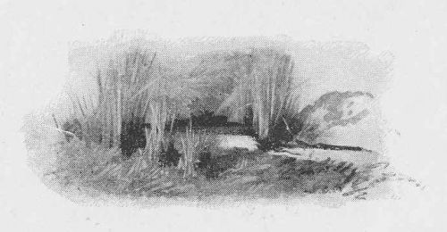
Approximte location of Little John's Well.
By Henrik Thiil Nielsen, 2013-08-04. Revised by Henrik Thiil Nielsen, 2018-01-02.
Sutcliffe (1899)[1] seems to be the first source to mention Little John's Well high on Stanbury Moor. He notes that it and the neighbouring Robin Hood's Well and Will Scarlet's Well are "[h]alf-hidden underground, and fringed with fern and bog-weed". Robin Hood's Well is first mentioned around the middle of the 19th century.
Allusions
Gazetteers
- Not included in Dobson, R. B., ed.; Taylor, J., ed. Rymes of Robyn Hood: an Introduction to the English Outlaw (London, 1976), pp. 293-311, but see p 311 (2nd item) for Robin Hood's Well.
Sources
- Robin Hood’s Well, Stanbury Moor, West Yorkshire
- Sutcliffe, Halliwell. By Moor and Fell: Landscapes and Lang-Settle Lore from West Yorkshire (London, 1899).
Maps
- 25" O.S. maps (no map overlays as of 1 Jan. 20118) (georeferenced)
- 6" O.S. map Yorkshire 199 (1851; surveyed 1848)
- 6" O.S. map Lancashire LVII.SE (1895: rev. 1892) (springs indicated without labels)
- 6" O.S. map Yorkshire CXCIX.SW & SE (1896; surveyed 1892)
- 6" O.S. map Yorkshire CXCIX.SW & SE (1910; rev. 1906)
- 6" O.S. map Lancashire LVII.SE (1915: rev. 1909-10)
- 6" O.S. map Lancashire LVII.SE (1915: rev. 1909-10) (georeferenced)
- 6" O.S. map Yorkshire LVII.SE (c. 1946; rev. 1910)
- 1:25,000 SD93 (1954; surveyed 1938) (wells shown and labelled "Sprs") (georeferenced)
- 1" O.S. Sheet 69 (Outline) (1899; rev. 1896) (wells not shown) (georeferenced)
- 1" O.S. Sheet 69 (Hills) (1899; rev. 1896) (wells not shown) (georeferenced)
Notes

