
Howe Robin (Crosby Ravensworth Fell): Difference between revisions
m (Text replacement - "=== Background ===" to "== Background ==") |
m (→Maps) |
||
| (11 intermediate revisions by the same user not shown) | |||
| Line 1: | Line 1: | ||
__NOTOC__{{PnItemTop|Lat=54.4882|Lon=-2.5812|AdmDiv=Westmorland|Vicinity=Crosby Ravensworth Fell, ''c.'' 1.7 km N of Orton|Type=Prehistoric site|Interest=Robin Hood name|Status=Extant|Demonym=|Riding=|GreaterLondon=|Year=1859|Aka=|Century=|Cluster1=Crosby Ravensworth Fell|Cluster2=|Cluster3=|Image=michael-graham-howe-robin.jpg|Postcards=|ExtraCat1=Places named Robin Hood's Grave|ExtraCat2=|ExtraCat3=|ExtraCat4=|ExtraCat5=|GeopointPrefix=|GeopointSuffix=|StatusSuffix=|DatePrefix=|DateSuffix=}} | __NOTOC__{{PnItemTop|Lat=54.4882|Lon=-2.5812|AdmDiv=Westmorland|Vicinity=Crosby Ravensworth Fell, ''c.'' 1.7 km N of Orton|Type=Prehistoric site|Interest=Robin Hood name|Status=Extant|Demonym=|Riding=|GreaterLondon=|Year=1859|Aka=|Century=|Cluster1=Crosby Ravensworth Fell|Cluster2=|Cluster3=|Image=michael-graham-howe-robin.jpg|Postcards=|ExtraCat1=Places named Robin Hood's Grave|ExtraCat2=|ExtraCat3=|ExtraCat4=|ExtraCat5=|GeopointPrefix=|GeopointSuffix=|StatusSuffix=|DatePrefix=|DateSuffix=}} | ||
{{#display_map:{{#var:Coords}}~{{#replace:{{PAGENAME}}|'|'}}|width=34%}}<div class="pnMapLegend">Robin Hood's Grave.</div> | {{#display_map:{{#var:Coords}}~{{#replace:{{PAGENAME}}|'|'}}|width=34%|service=leaflet|enablefullscreen=yes}}<div class="pnMapLegend">Robin Hood's Grave.</div> | ||
[[File:michael-graham-howe-robin.jpg|thumb|right|500px|Limestone Pavement on Crosby Ravensworth Fell / [http://www.geograph.org.uk/photo/5067255 Michael Graham, 30 July 2016, Creative Commons, via Geograph.]]] | |||
[[File:michael-graham-howe-robin.jpg|thumb|right|500px|Limestone Pavement on Crosby Ravensworth Fell / | |||
<p id="byline">By Henrik Thiil Nielsen, 2017-05-11. Revised by {{#realname:{{REVISIONUSER}}}}, {{REVISIONYEAR}}-{{REVISIONMONTH}}-{{REVISIONDAY2}}.</p> | <p id="byline">By Henrik Thiil Nielsen, 2017-05-11. Revised by {{#realname:{{REVISIONUSER}}}}, {{REVISIONYEAR}}-{{REVISIONMONTH}}-{{REVISIONDAY2}}.</p> | ||
<div class="no-img"> | <div class="no-img"> | ||
Howe Robin is a probably prehistoric site on Crosby Ravensworth Fell. A.H. Smith suggests in ''The Place-Names of Westmorland'' that the name may have been inspired by that of Robin Hood and points to a possible connection with [[Robin Hood's Grave (Crosby Ravensworth Fell)|Robin Hood's Grave]], ''c.'' 650 m NNW of the Howe. The first element, 'Howe', a reflex of 'haugr', means 'hill'. The earliest record of the name known to Smith is an 1859 MS Ordnance Survey name book.<ref>{{:Smith, Albert Hugh 1967a}}, pt. II, p. 160; and see pt. I, p. lxvi for source reference.</ref> The allusion cited below, dated ''c.'' 1860, is thus not much later. | Howe Robin is a probably prehistoric site on Crosby Ravensworth Fell. A.H. Smith suggests in ''The Place-Names of Westmorland'' that the name may have been inspired by that of Robin Hood and points to a possible connection with [[Robin Hood's Grave (Crosby Ravensworth Fell)|Robin Hood's Grave]], ''c.'' 650 m NNW of the Howe. The first element, 'Howe', a reflex of 'haugr', means 'hill'. The earliest record of the name known to Smith is an 1859 MS Ordnance Survey name book.<ref>{{:Smith, Albert Hugh 1967a}}, pt. II, p. 160; and see pt. I, p. lxvi for source reference.</ref> The allusion cited below, dated ''c.'' 1860, is thus not much later. | ||
According to PastScape, the Howe, surveyed by archaeologists in 1996, is possibly neolithic, a roughly heart-shaped area of limestone pavement measuring 250 x 220 metres, in part encircled by the natural limestone escarpment. The surviving scarp is discontinuous, 0.8–1.5 metres high, topped in places by an earthen bank, 2.2 metres at its widest, and 0.3 metres high. There are traces of artifical ditches. Stone Age pottery and other implements as well as flakes have been found within and near the enclosure, but a neolithic date cannot be established with certainty.<ref>[http://www.pastscape.org.uk/hob.aspx?hob_id=1057514 PastScape: Howe Robin.] See further {{:Brown, Moraig 1996a}}.</ref> | According to PastScape, the Howe, surveyed by archaeologists in 1996, is possibly neolithic, a roughly heart-shaped area of limestone pavement measuring 250 x 220 metres, in part encircled by the natural limestone escarpment. The surviving scarp is discontinuous, 0.8–1.5 metres high, topped in places by an earthen bank, 2.2 metres at its widest, and 0.3 metres high. There are traces of artifical ditches. Stone Age pottery and other implements as well as flakes have been found within and near the enclosure, but a neolithic date cannot be established with certainty.<ref>[http://www.pastscape.org.uk/hob.aspx?hob_id=1057514 PastScape: Howe Robin.] See further {{:Brown, Moraig 1996a}}.</ref>{{PnItemQry}} | ||
{{ | |||
== Gazetteers == | == Gazetteers == | ||
* Noted in {{:Dobson, Richard Barrie 1976a}}, p. 305, ''s.n.'' Robin Hood's Grave''. | * Noted in {{:Dobson, Richard Barrie 1976a}}, p. 305, ''s.n.'' Robin Hood's Grave''. | ||
| Line 21: | Line 14: | ||
* {{:Smith, Albert Hugh 1967a}}, pt. II, p. 160; and see pt. I, pp. lxvi, lxviii for source references. | * {{:Smith, Albert Hugh 1967a}}, pt. II, p. 160; and see pt. I, pp. lxvi, lxviii for source references. | ||
== Maps == | == Maps == | ||
* | * 25" O.S. map ''Westmorland'' XXI.12 (1861; surveyed ''c.'' 1858-59). No copy in NLS | ||
* [http://maps.nls.uk/view/125823393#zoom=4&lat=10112&lon=14222&layers=BT 25" O.S. map ''Westmorland'' XXI.12 (1898; rev. 1897)] | * [http://maps.nls.uk/view/125823393#zoom=4&lat=10112&lon=14222&layers=BT 25" O.S. map ''Westmorland'' XXI.12 (1898; rev. 1897)] | ||
* [http://maps.nls.uk/view/101104950#zoom=5&lat=5714&lon=7182&layers=BT 6" O.S. map ''Westmorland'' XXI.SE (1899; rev. 1897)] | * [http://maps.nls.uk/view/101104950#zoom=5&lat=5714&lon=7182&layers=BT 6" O.S. map ''Westmorland'' XXI.SE (1899; rev. 1897)] | ||
| Line 31: | Line 24: | ||
== Discussion == | == Discussion == | ||
* --> | * --> | ||
== Background == | == Background == | ||
* {{:Brown, Moraig 1996a}} | * {{:Brown, Moraig 1996a}} | ||
* [http://www.pastscape.org.uk/hob.aspx?hob_id=1057514 PastScape: Howe Robin.]<!-- | * [http://www.pastscape.org.uk/hob.aspx?hob_id=1057514 PastScape: Howe Robin.]<!-- | ||
== Brief mention == | |||
* --> | * --> | ||
{{PnItemAlsoSee}} | {{PnItemAlsoSee}} | ||
== Notes == | |||
<references/> | <references/> | ||
</div> | </div> | ||
{{ImgGalleryIntro}} | |||
<gallery widths="195px"> | |||
File:michael-graham-howe-robin.jpg|Limestone Pavement on Crosby Ravensworth Fell / [http://www.geograph.org.uk/photo/5067255 Michael Graham, 30 July 2016, Creative Commons, via Geograph.] | |||
File:david-brown-howe-robin.jpg|Limestone on Howe Robin / [http://www.geograph.org.uk/photo/1734319 David Brown, 3 Mar. 2010, Creative Commons, via Geograph.] | |||
</gallery> | |||
{{PnItemNav}} | {{PnItemNav}} | ||
Revision as of 12:18, 7 June 2019

By Henrik Thiil Nielsen, 2017-05-11. Revised by Henrik Thiil Nielsen, 2019-06-07.
Howe Robin is a probably prehistoric site on Crosby Ravensworth Fell. A.H. Smith suggests in The Place-Names of Westmorland that the name may have been inspired by that of Robin Hood and points to a possible connection with Robin Hood's Grave, c. 650 m NNW of the Howe. The first element, 'Howe', a reflex of 'haugr', means 'hill'. The earliest record of the name known to Smith is an 1859 MS Ordnance Survey name book.[1] The allusion cited below, dated c. 1860, is thus not much later.
According to PastScape, the Howe, surveyed by archaeologists in 1996, is possibly neolithic, a roughly heart-shaped area of limestone pavement measuring 250 x 220 metres, in part encircled by the natural limestone escarpment. The surviving scarp is discontinuous, 0.8–1.5 metres high, topped in places by an earthen bank, 2.2 metres at its widest, and 0.3 metres high. There are traces of artifical ditches. Stone Age pottery and other implements as well as flakes have been found within and near the enclosure, but a neolithic date cannot be established with certainty.[2]Template:PnItemQry
Gazetteers
- Noted in Dobson, R. B., ed.; Taylor, J., ed. Rymes of Robyn Hood: an Introduction to the English Outlaw (London, 1976), p. 305, s.n. Robin Hood's Grave.
Sources
- Lindsay, David, compil. An Inventory of the Historical Monuments in Westmorland (Royal Commission on Historical Monuments, England) (London, 1936), p. 90, item No. 50.
- Smith, A.H. The Place-Names of Westmorland (English Place-Name Society, vols. XLII, XLIII) (Cambridge, 1967), pt. II, p. 160; and see pt. I, pp. lxvi, lxviii for source references.
Maps
- 25" O.S. map Westmorland XXI.12 (1861; surveyed c. 1858-59). No copy in NLS
- 25" O.S. map Westmorland XXI.12 (1898; rev. 1897)
- 6" O.S. map Westmorland XXI.SE (1899; rev. 1897)
- 6" O.S. map Westmorland XXI.SE (1899; rev. 1897) (georeferenced)
- 25" O.S. map Westmorland XXI.12 (1915; rev. 1912)
- 6" O.S. map Westmorland XXI.SE (1920; rev. 1912)
- 6" O.S. map Westmorland XXI.SE (c. 1936; rev. 1912)
- 6" O.S. map Westmorland XXI.SE (c. 1946; rev. 1912).
Background
- [Brown, Moraig]; [Barber, Martyn]; [Topping, Peter], ed. Howe Robin, Crosby Ravensworth, Cumbria, NMR Number NY 61 SW 75, Industry and Enclosure in the Neolithic (Royal Commission on the Historical Monuments of England) (Cambridge, 1996)
- PastScape: Howe Robin.
Notes
- ↑ Smith, A.H. The Place-Names of Westmorland (English Place-Name Society, vols. XLII, XLIII) (Cambridge, 1967), pt. II, p. 160; and see pt. I, p. lxvi for source reference.
- ↑ PastScape: Howe Robin. See further [Brown, Moraig]; [Barber, Martyn]; [Topping, Peter], ed. Howe Robin, Crosby Ravensworth, Cumbria, NMR Number NY 61 SW 75, Industry and Enclosure in the Neolithic (Royal Commission on the Historical Monuments of England) (Cambridge, 1996).
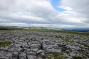
Limestone Pavement on Crosby Ravensworth Fell / Michael Graham, 30 July 2016, Creative Commons, via Geograph.
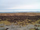
Limestone on Howe Robin / David Brown, 3 Mar. 2010, Creative Commons, via Geograph.
