|
|
| Line 1: |
Line 1: |
| __NOTOC__ | | __NOTOC__{{PnItemTop|Lat=53.618650|Lon=-1.791456|AdmDiv=Yorkshire|Vicinity=3 km S of Huddersfield|Type=Thoroughfare|Interest=Robin Hood name|Status=Extant|Demonym=|Riding=West|GreaterLondon=|Year=|Aka=|Century=|Cluster1=|Cluster2=|Cluster3=|Image=hood_street_berry_brow_huddersfield_google_earth.jpg|Postcards=|ExtraCat1=|ExtraCat2=|ExtraCat3=|ExtraCat4=|ExtraCat5=|GeopointPrefix=|GeopointSuffix=|VicinitySuffix=|StatusSuffix=|DatePrefix=|DateSuffix=?}} |
| {{Infobox | | {{#display_map:{{#var:Coords}}|width=34%}}<div class="pnMapLegend">Approximate location of Hood Street</div> |
| |header1=Locality
| |
| |label2=Coordinates
| |
| |data2=[[Geopoint::53.618650,-1.791456]]
| |
| |label3=Adm. div.
| |
| |data3=[[pnadmdiv::West Riding of Yorkshire]]
| |
| |label4=Vicinity
| |
| |data4=[[pnvicinity::3 km S of Huddersfield]]
| |
| |label5=Type
| |
| |data5=[[pntype::Thoroughfare]]
| |
| |label6=Interest
| |
| |data6=[[pninterest::Robin Hood name]]
| |
| |label7=Status
| |
| |data7=[[pnstatus::Extant]]
| |
| |label8=First Record
| |
| |data8=[[pnfirstrecord::]]?
| |
| }} | |
| {{#display_map:53.618650,-1.791456|width=34%}}<div class="pnMapLegend">Approximate location of Hood Street</div> | |
| [[File:hood_street_berry_brow_huddersfield_google_earth.jpg|500px|thumb|right|Hood Street (''photo:'' Google Earth)]] | | [[File:hood_street_berry_brow_huddersfield_google_earth.jpg|500px|thumb|right|Hood Street (''photo:'' Google Earth)]] |
| <p id="byline">By Henrik Thiil Nielsen, 2013-08-04. Revised by {{#realname:{{REVISIONUSER}}}}, {{REVISIONYEAR}}-{{REVISIONMONTH}}-{{REVISIONDAY2}}.</p><div class="no-img"> | | <p id="byline">By Henrik Thiil Nielsen, 2013-08-04. Revised by {{#realname:{{REVISIONUSER}}}}, {{REVISIONYEAR}}-{{REVISIONMONTH}}-{{REVISIONDAY2}}.</p><div class="no-img"> |
| Line 29: |
Line 12: |
|
| |
|
|
| |
|
| </div> | | </div><!-- |
| <div id="dplcatlinks" class="subcategory"><div id="dplcatarea"> | | {{ImgGalleryIntro}} |
| {{#ask: [[Category:English place-names]]
| | <gallery widths="195px"> |
| [[Category:West Riding of Yorkshire place-names]][[Utitle::<<{{#replace:{{uc:{{PAGENAME}}}}|'|'}}]]|order=descending|searchlabel=|format=template|introtemplate=BeforeNav|template=Nav|outrotemplate=Previous|link=none|limit=1|sort=Utitle}}[[West Riding of Yorkshire place-names]]{{#ask: [[Category:English place-names]]
| | FOR EACH IMAGE: File:_FILENAME.jpg|_LEGEND / [_URL _PHOTOGRAPHER, _DAY _MON. _YEAR, Creative Commons.] |
| [[Category:West Riding of Yorkshire place-names]][[Utitle::>>{{#replace:{{uc:{{PAGENAME}}}}|'|'}}]]|order=ascending|searchlabel=|format=template|introtemplate=BeforeNav|template=Nav|outrotemplate=Next|link=none|limit=1|sort=Utitle}}
| | </gallery>--> |
|
| |
|
| <p>{{#ask: [[Category:English place-names]][[Utitle::<<{{#replace:{{uc:{{PAGENAME}}}}|'|'}}]]|order=descending|searchlabel=|format=template|introtemplate=BeforeNav|template=Nav|outrotemplate=Previous|link=none|limit=1|sort=Utitle}}[[Yorkshire place-names]]{{#ask: [[Category:English place-names]][[Utitle::>>{{#replace:{{uc:{{PAGENAME}}}}|'|'}}]]|order=ascending|searchlabel=|format=template|introtemplate=BeforeNav|template=Nav|outrotemplate=Next|link=none|limit=1|sort=Utitle}}</p>
| | {{PnItemNav}} |
| | |
| {{#ask: [[Category:English place-names]][[Utitle::<<{{#replace:{{uc:{{PAGENAME}}}}|'|'}}]]|order=descending|searchlabel=|format=template|introtemplate=BeforeNav|template=Nav|outrotemplate=Previous|link=none|limit=1|sort=Utitle}}[[Place-names]]{{#ask: [[Category:English place-names]][[Utitle::>>{{#replace:{{uc:{{PAGENAME}}}}|'|'}}]]|order=ascending|searchlabel=|format=template|introtemplate=BeforeNav|template=Nav|outrotemplate=Next|link=none|limit=1|sort=Utitle}}</div></div>
| |
| [[Category:English place-names]]
| |
| [[Category:West Riding of Yorkshire place-names]]
| |
| [[Category:Place-names-topics]]
| |
| [[Category:Berry Brow place-name cluster]]
| |
| [[Category:unknown century]]
| |
| {{#set:century=?}}
| |
| {{#set:Utitle={{#replace:{{uc:{{PAGENAME}}}}|'|'}}}}
| |
| {{#set:Pnimage=hood_street_berry_brow_huddersfield_google_earth.jpg}}
| |
| {{#set:Pnimage=hood_street_berry_brow_huddersfield_google_earth.jpg}}
| |
Template:PnItemTop
Loading map...
{"minzoom":false,"maxzoom":false,"mappingservice":"leaflet","width":"34%","height":"400px","centre":false,"title":"","label":"","icon":"","lines":[],"polygons":[],"circles":[],"rectangles":[],"copycoords":false,"static":false,"zoom":false,"defzoom":9,"layers":["OpenStreetMap","NLS","Stamen.Terrain"],"image layers":[],"overlays":[],"resizable":false,"fullscreen":false,"scrollwheelzoom":true,"cluster":false,"clustermaxzoom":20,"clusterzoomonclick":true,"clustermaxradius":80,"clusterspiderfy":true,"geojson":"","clicktarget":"","imageLayers":[],"locations":[],"imageoverlays":null}
Approximate location of Hood Street
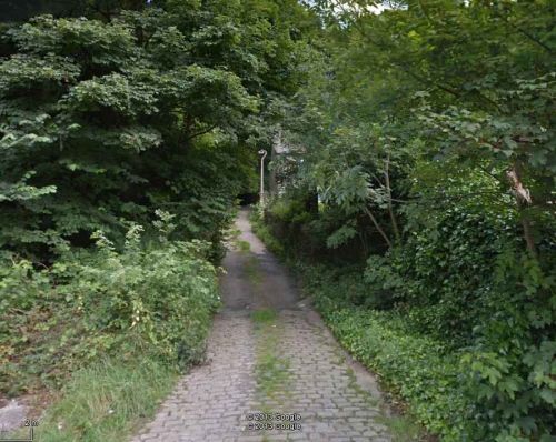
Hood Street (
photo: Google Earth)
By Henrik Thiil Nielsen, 2013-08-04. Revised by Henrik Thiil Nielsen, 2017-12-06.
Hood Street is a short, roughly L-shaped road off Woodhead Road. A house on Hood Street was called Robin Hood House, and in the immediate vicinity is found another small road named Robin Hood Hill. Places named after Robin Hood hardly ever omit the outlaw's first name, so most likely the name Hood Street is not related to the outlaw, but presumably it inspired the names Robin Hood House and Robin Hood Hill.
Gazetteers
Also see
Template:PnItemNav

