Hathersage Churchyard: Difference between revisions
From International Robin Hood Bibliography
m (Text replacement - "PnItemTop" to "PlaceNamesItemTop") |
m (Text replacement - "ImgGalleryIntro" to "ImageGalleryIntroduction") |
||
| (2 intermediate revisions by the same user not shown) | |||
| Line 15: | Line 15: | ||
* [https://en.wikipedia.org/wiki/St_Michael_and_All_Angels%27_Church,_Hathersage Wikipedia: St Michael and All Angels' Church, Hathersage.] | * [https://en.wikipedia.org/wiki/St_Michael_and_All_Angels%27_Church,_Hathersage Wikipedia: St Michael and All Angels' Church, Hathersage.] | ||
{{ | {{PlaceNamesItemAlsoSee}} | ||
== Notes == | == Notes == | ||
| Line 22: | Line 22: | ||
<!--<div id="gallery"> | <!--<div id="gallery"> | ||
{{ | {{ImageGalleryIntroduction}} | ||
<gallery widths="195px"> | <gallery widths="195px"> | ||
</gallery> | </gallery> | ||
</div>--> | </div>--> | ||
{{ | {{PlaceNamesItemNavigation}} | ||
Latest revision as of 13:50, 7 January 2021
| Locality | |
|---|---|
| Coordinate | 53.333281, -1.650262 |
| Adm. div. | Derbyshire |
| Vicinity | Hathersage |
| Type | Area |
| Interest | Local tradition |
| Status | Extant? |
| First Record | |
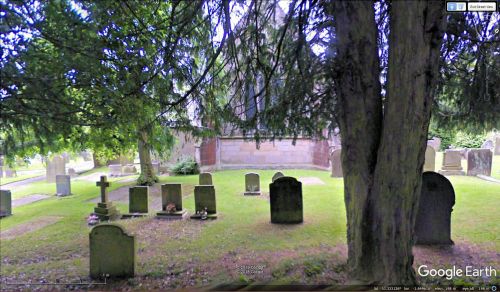
Hathersage Churchyard.
By Henrik Thiil Nielsen, 2019-03-17. Revised by Henrik Thiil Nielsen, 2021-01-07.
Robin Hood is or was alleged to have shot an arrow from Robin Hood's Stoop on Offerton Moor which landed in the graveyard of St Michael and All Angels' Church in Hathersage, abot 2 km north-east of the Stoop.[1]
Gazetteers
- Dobson, R. B., ed.; Taylor, J., ed. Rymes of Robyn Hood: an Introduction to the English Outlaw (London, 1976); no separate entry, but see p. 297, s.n. 'Robin Hood's Stoop'.
Sources
- Cameron, Kenneth. The Place-Names of Derbyshire (English Place-Name Society, vols. XXVII-XXIX) (Cambridge, 1959), pt. I, p. 156; and see pt. I, p. lvii.
Background
- Wikipedia: St John the Baptist's Church, Bamford
- Wikipedia: St Michael and All Angels' Church, Hathersage.
Also see
Notes
- ↑ See Dobson, R. B., ed.; Taylor, J., ed. Rymes of Robyn Hood: an Introduction to the English Outlaw (London, 1976), p. 297, s.n. 'Robin Hood's Stoop'; Cameron, Kenneth. The Place-Names of Derbyshire (English Place-Name Society, vols. XXVII-XXIX) (Cambridge, 1959), pt. I, p. 156; and see pt. I, p. lvii.

