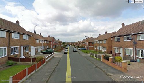
Friar Lane (Warsop)
From International Robin Hood Bibliography
| Locality | |
|---|---|
| Coordinate | 53.194874, -1.143861 |
| Adm. div. | Nottinghamshire |
| Vicinity | Side street on NE side of Robin Hood Avenue in Warsop |
| Type | Thoroughfare |
| Interest | Robin Hood name |
| Status | Extant |
| First Record | |
Friar Lane, Warsop.
By Henrik Thiil Nielsen, 2018-05-20. Revised by Henrik Thiil Nielsen, 2021-01-07.
Friar Lane is a residential street on the north-east side of Robin Hood Avenue in Warsop, a neighbourhood where one also finds Little John Avenue, Sherwood Street and Maid Marion Rise. Judging by the look of the houses, Friar Lane is of 20th century date.
Gazetteers
- Not included in Dobson, R. B., ed.; Taylor, J., ed. Rymes of Robyn Hood: an Introduction to the English Outlaw (London, 1976), pp. 293-311.
Maps
- 25" O.S. map Nottinghamshire XXIII.2 (1885; surveyed 1884)
- 25" O.S. map Nottinghamshire XXIII.2 (1898; rev. 1897)
- 25" O.S. map Nottinghamshire XXIII.2 (1898; rev. 1897) (georeferenced)
- 25" O.S. map Nottinghamshire XXIII.2 (1916; rev. 1914)
- 6" O.S. map Nottinghamshire XXIII.NW (1885; surveyed 1875-84)
- 6" O.S. map Derbyshire XXXIa.NW (1900; rev. 1897)
- 6" O.S. map Derbyshire XXXIa.NW (1900; rev. 1897) (georeferenced)
- 6" O.S. map Derbyshire XXXIa.NW (1920; rev. 1914)
- 6" O.S. map Derbyshire XXXIa.NW (c. 1948; rev. 1938).
Also see

