
Chinley Churn (Chinley): Difference between revisions
mNo edit summary |
mNo edit summary |
||
| Line 5: | Line 5: | ||
According to early 19th century tradition, Robin Hood shot an arrow from [[Dipping Stone (Whaley Moor)|the Dipping Stone at Whaley Moor]] to Chinley Churn. | According to early 19th century tradition, Robin Hood shot an arrow from [[Dipping Stone (Whaley Moor)|the Dipping Stone at Whaley Moor]] to Chinley Churn. | ||
William Marriott's account in his ''Antiquities of Lyme and its Vicinity'', published in 1810 (see Allusions), | William Marriott's account in his ''Antiquities of Lyme and its Vicinity'', published in 1810 (see Allusions), is the only known source for this tradition. Unfortunately he was more interested in developing elaborate hypotheses about the origins of various stone monuments in Lyme Handley and its vicinity than in providing a detailed account of the popular traditions on which his speculation was largely based. | ||
{{PnItemQry}} | {{PnItemQry}} | ||
== Gazetteers == | == Gazetteers == | ||
Revision as of 15:57, 21 February 2019
[[File:|thumb|right|500px|Chinley Churn / Rude Health, 19 Jan. 2011, Creative Commons via Geograph.]]
By Henrik Thiil Nielsen, 2019-02-21. Revised by Henrik Thiil Nielsen, 2019-02-21.
According to early 19th century tradition, Robin Hood shot an arrow from the Dipping Stone at Whaley Moor to Chinley Churn.
William Marriott's account in his Antiquities of Lyme and its Vicinity, published in 1810 (see Allusions), is the only known source for this tradition. Unfortunately he was more interested in developing elaborate hypotheses about the origins of various stone monuments in Lyme Handley and its vicinity than in providing a detailed account of the popular traditions on which his speculation was largely based. Template:PnItemQry
Gazetteers
- Not included in Dobson, R. B., ed.; Taylor, J., ed. Rymes of Robyn Hood: an Introduction to the English Outlaw (London, 1976), pp. 293-311.
Sources
- Marriott, William. The Antiquities of Lyme and its Vicinity (Stockport, 1810), p. , 18-27, 58-59, 393-97, and passim.
Maps
- 6" O.S. map Derbyshire VIII.NE (1882; surveyed 1879)
- 6" O.S. map Derbyshire VIII.NE (1899; rev. 1896-97) (georeferenced)
- 6" O.S. map Derbyshire VIII.NE (1899; rev. 1896-97)
- 6" O.S. map Derbyshire VIII (1924; rev. 1919-20)
- 6" O.S. map Derbyshire VIII.NE (1924; rev. 1919)
- 6" O.S. map Derbyshire VIII.NE (c. 1946; rev. 1938)
- 25" O.S: map Derbyshire VIII.8 (c. 1880; surveyed c. 1878-79). No Copy in NLS
- 25" O.S: map Derbyshire VIII.8 (c. 1899; rev. c. 1897). No Copy in NLS
- 25" O.S. map Derbyshire VIII.8 (1921; rev. 1919) (georeferenced)]
- 25" O.S. map Derbyshire VIII.8 (1921; rev. 1919)
- 25" O.S. map Derbyshire VIII.8 (1945; rev. 1938).
Background
Notes
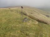
Chinley Churn / Rude Health, 19 Jan. 2011, Creative Commons via Geograph.
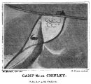
Traces of a supposed Roman encampment / Antiquities of Lyme and its Vicinity (1810), plate facing p. 306.

